Ayr Central Conservation Area Character Appraisal - South Ayrshire ...
Ayr Central Conservation Area Character Appraisal - South Ayrshire ...
Ayr Central Conservation Area Character Appraisal - South Ayrshire ...

Create successful ePaper yourself
Turn your PDF publications into a flip-book with our unique Google optimized e-Paper software.
<strong>Ayr</strong> <strong>Central</strong> <strong>Conservation</strong> <strong>Area</strong> <strong>Character</strong> <strong>Appraisal</strong><br />
Part One<br />
DEVELOPMENT HISTORY<br />
Prehistoric<br />
It is likely that the area now covered by the town was<br />
occupied in the prehistoric period. No in situ prehistoric<br />
remains have been recovered during excavations but<br />
several stray finds, such as a stone axe from Alloway<br />
Street and a fragment of cannel coal bangle from King<br />
Street in Newton, provide general evidence for activity.<br />
The title ‘<strong>Ayr</strong>’ is usually taken to be derived from a very<br />
early Indo-European word for river.<br />
Mediaeval<br />
William the Lion built a new castle at <strong>Ayr</strong> in 1197 and a<br />
royal burgh was founded shortly after. Presumably this<br />
increased the king’s control over an area that was very<br />
much part of Scotland’s western frontier. The castle<br />
provided protection to the natural harbour at the <strong>Ayr</strong>’s<br />
mouth. The <strong>Ayr</strong> could be forded immediately upriver<br />
from the harbour and this meant that several land routes<br />
converged here. The town was to develop into the<br />
west coast’s pre-eminent port and it was foreign trade,<br />
primarily with Ireland, that stimulated early growth.<br />
There may have been an existing settlement prior to the<br />
founding of the burgh and some excavations on High<br />
Street have uncovered 12th century pottery. It has been<br />
suggested that the earliest part of the town was located<br />
around Sandgate, but excavations have yet to find any<br />
firm evidence. The site of the original parish church of St<br />
John’s has been excavated and architectural fragments<br />
recovered suggest it too was built around the time of<br />
the castle.<br />
The town seems to have developed fairly rapidly with<br />
High Street becoming its main axis. Development<br />
presumably spread down from the junction with<br />
Sandgate and at least by the 14th century there were<br />
properties to the south of Carrick Street. Even further<br />
south recent excavations at Kyle Street found remains<br />
of a 13th to 14th century tannery. During this period<br />
documents record that a large proportion of exports<br />
from the town were hides.<br />
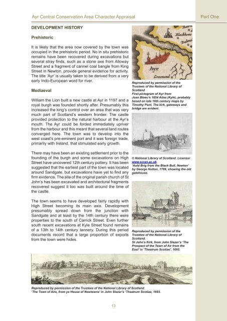
Reproduced by permission of the<br />
Trustees of the National Library of<br />
Scotland<br />
First pictogram of <strong>Ayr</strong> from<br />
Joan Blaeu’s 1654 Atlas (Kyle), probably<br />
based on late 16th century maps by<br />
Timothy Pont. The kirk, gateways and<br />
bridge are evident.<br />
© National Library of Scotland. Licensor<br />
www.scran.ac.uk.<br />
‘Auld Brig from the Black Bull, Newton’<br />
by George Hutton, 1789, showing the old<br />
gatehouse.<br />
Reproduced by permission of the<br />
Trustees of the National Library of<br />
Scotland.<br />
St John’s Kirk, from John Slezer’s ‘The<br />
Prospect of the Town of Air from the<br />
East’ in ‘Theatrum Scotiae’, 1693.<br />
Reproduced by permission of the Trustees of the National Library of Scotland.<br />
‘The Town of Aire, from ye House of Newtowne’ in John Slezer’s ‘Theatrum Scotiae, 1693.<br />
13