Ayr Central Conservation Area Character Appraisal - South Ayrshire ...
Ayr Central Conservation Area Character Appraisal - South Ayrshire ...
Ayr Central Conservation Area Character Appraisal - South Ayrshire ...

You also want an ePaper? Increase the reach of your titles
YUMPU automatically turns print PDFs into web optimized ePapers that Google loves.
<strong>Ayr</strong> <strong>Central</strong> <strong>Conservation</strong> <strong>Area</strong> <strong>Character</strong> <strong>Appraisal</strong><br />
Part One<br />
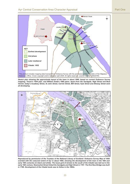
KEY<br />
Earliest development<br />
2nd phase<br />
Later mediaeval<br />
Citadel. 1652<br />
This product includes mapping data licensed from Ordnance Survey with the permission of the Controller of Her Majesty’s<br />
Stationery Office. Crown copyright and/or database right 2008. All rights reserved. Licence number 100020765.<br />
Sketch plan showing the approximate layout of the town in about 1660, based on current Ordnance Survey<br />
mapping, Tessin’s 1654 plan, and William Dodd’s 1969 plans. Apart from the Sandgate, High Street and Boat<br />
Vennel, today’s Academy Street, St John Street, Carrick Street, Mill Street, Kyle Street and Alloway Street were<br />
all developing.<br />
Reproduced by permission of the Trustees of the National Library of Scotland. Ordnance Survey Map of 1858<br />
overlaid with the coloured extent of <strong>Ayr</strong> in about 1660, showing the development of the town in the 18th and<br />
early 19th centuries (in black and white). The loose grid of streets to the south of the Citadel was laid out in the<br />
early 19th century. Newmarket Street linked the Sandgate and High Street in 1767. The first New Bridge was built<br />
in 1786. Development of the Citadel lands was to follow in the 1860s.<br />
23