t The California Surveyor - CLSA
t The California Surveyor - CLSA
t The California Surveyor - CLSA
Create successful ePaper yourself
Turn your PDF publications into a flip-book with our unique Google optimized e-Paper software.
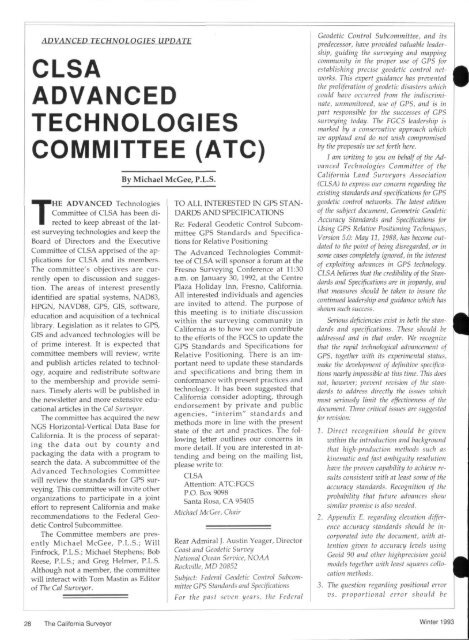
ADVANCED TECHNOLOGIES UPDATE<br />
<strong>CLSA</strong><br />
ADVANCED<br />
TECHNOLOGIES<br />
COMMITTEE (ATC)<br />
THE ADVANCED Technologies<br />
Committee of <strong>CLSA</strong> has been directed<br />
to keep abreast of the latest<br />
surveying technologies and keep the<br />
Board of Directors and the Executive<br />
Committee of <strong>CLSA</strong> apprised of the applications<br />
for <strong>CLSA</strong> and its members.<br />
<strong>The</strong> committee's objectives are currently<br />
open to discussion and suggestion.<br />
<strong>The</strong> areas of interest presently<br />
identified are spatial systems, NAD83,<br />
HPGN, NAVD88, GPS, GIS, software,<br />
education and acquisition of a technical<br />
library. Legislation as it relates to GPS,<br />
GIS and advanced technologies will be<br />
of prime interest. It is expected that<br />
committee members will review, write<br />
and publish articles related to technology,<br />
acquire and redistribute software<br />
to the membership and provide seminars.<br />
Timely alerts will be published in<br />
the newsletter and more extensive educational<br />
articles in the Cal <strong>Surveyor</strong>.<br />
<strong>The</strong> committee has acquired the new<br />
NGS Horizontal-Vertical Data Base for<br />
<strong>California</strong>. It is the process of separating<br />
the data out by county and<br />
packaging the data with a program to<br />
search the data. A subcommittee of the<br />
Advanced Technologies Committee<br />
will review the standards for GPS surveying.<br />
This committee will invite other<br />
organizations to participate in a joint<br />
effort to represent <strong>California</strong> and make<br />
recommendations to the Federal Geodetic<br />
Control Subcommittee.<br />
<strong>The</strong> Committee members are presently<br />
Michael McGee, P.L.S.; Will<br />
Finfrock, P.L.S.; Michael Stephens; Bob<br />
Reese, P.L.S.; and Greg Helmer, P.L.S.<br />
Although not a member, the committee<br />
will interact with Tom Mastin as Editor<br />
of <strong>The</strong> Cal <strong>Surveyor</strong>.<br />
By Michael McGee, P.L.S.<br />
TO ALL INTERESTED DM GPS STAN<br />
DARDS AND SPECIFICATIONS<br />
Re: Federal Geodetic Control Subcommittee<br />
GPS Standards and Specifications<br />
for Relative Positioning<br />
<strong>The</strong> Advanced Technologies Committee<br />
of <strong>CLSA</strong> will sponsor a forum at the<br />
Fresno Surveying Conference at 11:30<br />
a.m. on January 30, 1992, at the Centre<br />
Plaza Holiday Inn, Fresno, <strong>California</strong>.<br />
All interested individuals and agencies<br />
are invited to attend. <strong>The</strong> purpose of<br />
this meeting is to initiate discussion<br />
within the surveying community in<br />
<strong>California</strong> as to how we can contribute<br />
to the efforts of the FGCS to update the<br />
GPS Standards and Specifications for<br />
Relative Positioning. <strong>The</strong>re is an important<br />
need to update these standards<br />
and specifications and bring them in<br />
conformance with present practices and<br />
technology. It has been suggested that<br />
<strong>California</strong> consider adopting, through<br />
endorsement by private and public<br />
agencies, "interim" standards and<br />
methods more in line with the present<br />
state of the art and practices. <strong>The</strong> following<br />
letter outlines our concerns in<br />
more detail. If you are interested in attending<br />
and being on the mailing list,<br />
please write to:<br />
<strong>CLSA</strong><br />
Attention: ATCFGCS<br />
P.O. Box 9098<br />
Santa Rosa, CA 95405<br />
Michael McGee, Chair<br />
Rear Admiral J. Austin Yeager, Director<br />
Coast and Geodetic Survey<br />
National Ocean Service, NOAA<br />
Rockville, MD 20852<br />
Subject: Federal Geodetic Control Subcommittee<br />
GPS Standards and Specifications<br />
For the past seven years, the Federal<br />
Geodetic Control Subcommittee, and its<br />
predecessor, have provided valuable leadership,<br />
guiding the surveying and mapping<br />
community in the proper use of GPS for<br />
establishing precise geodetic control networks.<br />
This expert guidance has prevented<br />
the proliferation of geodetic disasters which<br />
could have occurred from the indiscriminate,<br />
unmonitored, use of GPS, and is in<br />
part responsible for the successes of GPS<br />
surveying today. <strong>The</strong> FGCS leadership is<br />
marked by a conservative approach which<br />
we applaud and do not wish compromised<br />
by the proposals we set forth here.<br />
I am writing to you on behalf of the Advanced<br />
Technologies Committee of the<br />
<strong>California</strong> Land <strong>Surveyor</strong>s Association<br />
(<strong>CLSA</strong>) to express our concern regarding the<br />
existing standards and specifications for GPS<br />
geodetic control networks. <strong>The</strong> latest edition<br />
of the subject document, Geometric Geodetic<br />
Accuracy Standards and Specifications for<br />
Using GPS Relative Positioning Techniques,<br />
Version 5.0: May 11, 1988, has become outdated<br />
to the point of being disregarded, or in<br />
some cases completely ignored, in the interest<br />
of exploiting advances in GPS technology.<br />
<strong>CLSA</strong> believes that the credibility of the Standards<br />
and Specifications are in jeopardy, and<br />
that measures should be taken to insure the<br />
continued leadership and guidance which has<br />
shown such success.<br />
Serious deficiencies exist in both the standards<br />
and specifications. <strong>The</strong>se should be<br />
addressed and in that order. We recognize<br />
that the rapid technological advancement of<br />
GPS, together with its experimental status,<br />
make the development of definitive specifications<br />
nearly impossible at this time. This does<br />
not, however; prevent revision of the standards<br />
to address directly the issues which<br />
most seriously limit the effectiveness of the<br />
document. Three critical issues are suggested<br />
for revision:<br />
1. Direct recognition should be given<br />
within the introduction and background<br />
that high-production methods such as<br />
kinematic and fast ambiguity resolution<br />
have the proven capability to achieve results<br />
consistent with at least some of the<br />
accuracy standards. Recognition of the<br />
probability that future advances show<br />
similar promise is also needed.<br />
2. Appendix E. regarding elevation difference<br />
accuracy standards should be incorporated<br />
into the document, with attention<br />
given to accuracy levels using<br />
Geoid 90 and other highprecision geoid<br />
models together with least squares collocation<br />
methods.<br />
3. <strong>The</strong> question regarding positional error<br />
vs. proportional error should be<br />
28 <strong>The</strong> <strong>California</strong> <strong>Surveyor</strong> Winter 1993


