

GS1-2-3-4 Goodwin Sands - United Kingdom Hydrographic Office
GS1-2-3-4 Goodwin Sands - United Kingdom Hydrographic Office
GS1-2-3-4 Goodwin Sands - United Kingdom Hydrographic Office

You also want an ePaper? Increase the reach of your titles
YUMPU automatically turns print PDFs into web optimized ePapers that Google loves.
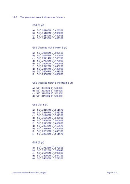
12.8 The proposed area limits are as follows –<br />
<strong>GS1</strong> (3 yr)<br />
a) 51˚.16100N 1˚.47550E<br />
b) 51˚.15180N 1˚.50900E<br />
c) 51˚.13640N 1˚.48200E<br />
d) 51˚.14250N 1˚.46330E<br />
GS2 (focused Gull Stream 3 yr)<br />
a) 51˚.30583N 1˚.50350E<br />
b) 51˚.30583N 1˚.52000E<br />
c) 51˚.29714N 1˚.50579E<br />
d) 51˚.27625N 1˚.47800E<br />
e) 51˚.26000N 1˚.46000E<br />
f) 51˚.23420N 1˚.44520E<br />
g) 51˚.23667N 1˚.43000E<br />
h) 51˚.26067N 1˚.45150E<br />
i) 51˚.29583N 1˚.48883E<br />
GS2 (focused North Sand Head 3 yr)<br />
a) 51˚.33333N 1˚.53600E<br />
b) 51˚.33333N 1˚.55000E<br />
c) 51˚.31960N 1˚.55250E<br />
d) 51˚.31960N 1˚.53600E<br />
GS2 (full 6 yr)<br />
a) 51˚.34167N 1˚.51167E<br />
b) 51˚.34167N 1˚.54833E<br />
c) 51˚.31960N 1˚.55250E<br />
d) 51˚.31960N 1˚.54300E<br />
e) 51˚.29000N 1˚.50000E<br />
f) 51˚.25250N 1˚.46000E<br />
g) 51˚.23333N 1˚.45067E<br />
h) 51˚.23667N 1˚.43000E<br />
i) 51˚.26333N 1˚.44333E<br />
j) 51˚.32333N 1˚.51167E<br />
GS3 (6 yr)<br />
a) 51˚.27825N 1˚.57950E<br />
b) 51˚.27825N 1˚.58869E<br />
c) 51˚.25690N 1˚.59000E<br />
d) 51˚.24090N 1˚.58415E<br />
e) 51˚.24090N 1˚.57950E<br />
Assessment <strong>Goodwin</strong> <strong>Sands</strong>/2009 – Original Page 15 of 51


