

GS1-2-3-4 Goodwin Sands - United Kingdom Hydrographic Office
GS1-2-3-4 Goodwin Sands - United Kingdom Hydrographic Office
GS1-2-3-4 Goodwin Sands - United Kingdom Hydrographic Office

Create successful ePaper yourself
Turn your PDF publications into a flip-book with our unique Google optimized e-Paper software.
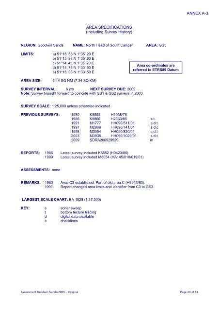
ANNEX A-3<br />
AREA SPECIFICATIONS<br />
(Including Survey History)<br />
REGION: <strong>Goodwin</strong> <strong>Sands</strong> NAME: North Head of South Calliper AREA: GS3<br />
LIMITS:<br />
AREA SIZE:<br />
a) 51°16’.63 N 1°35’.20 E<br />
b) 51°15’.93 N 1°35’.60 E<br />
c) 51°14’.43 N 1°35’.20 E<br />
d) 51°14’.73 N 1°33’.50 E<br />
e) 51°16’.03 N 1°33’.50 E<br />
2.14 SQ NM (7.34 SQ KM)<br />
Area co-ordinates are<br />
referred to ETRS89 Datum<br />
SURVEY INTERVAL: 6 yrs NEXT SURVEY DUE: 2009<br />
Note: Survey brought forward to coincide with <strong>GS1</strong> & GS2 surveys in 2003.<br />
SURVEY SCALE: 1:25,000 unless otherwise indicated<br />
PREVIOUS SURVEYS: 1980 K8552 H1938/78<br />
1986 K9866 H2333/85 s.t.<br />
1991 M1777 HH090/511/01 s.d.t<br />
1997 M2866 HH090/741/01 s.d.c<br />
1998 M3054 HH090/820/01 s.d.t<br />
2003 M3935 HH090/1029/01 s.d.t<br />
2009 SDRA200929529 m<br />
REPORTS: 1986 Latest survey included K8552 (H0423/86)<br />
1999 Latest survey included M3054 (HA145/010/019/01)<br />
ASSESSMENTS: none<br />
REMARKS: 1980 Area C3 established. Part of old area C (H3913/80).<br />
1999 Report changed area limits and identifier from C3 to GS3<br />
LARGEST SCALE CHART: BA 1828 (1:37,500)<br />
KEY: s sonar sweep<br />
t bottom texture tracing<br />
d digital data available<br />
c checklines<br />
Assessment <strong>Goodwin</strong> <strong>Sands</strong>/2009 – Original Page 20 of 51


