

GS1-2-3-4 Goodwin Sands - United Kingdom Hydrographic Office
GS1-2-3-4 Goodwin Sands - United Kingdom Hydrographic Office
GS1-2-3-4 Goodwin Sands - United Kingdom Hydrographic Office

Create successful ePaper yourself
Turn your PDF publications into a flip-book with our unique Google optimized e-Paper software.
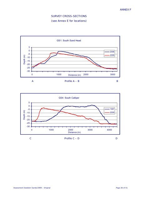
ANNEX F<br />
SURVEY CROSS-SECTIONS<br />
(see Annex E for locations)<br />
<strong>GS1</strong>: South Sand Head<br />
Depth (m)<br />
5<br />
0<br />
-5<br />
-10<br />
-15<br />
-20<br />
-25<br />
-30<br />
2006<br />
2009<br />
0 1000 2000 3000<br />
Distance (m)<br />
A Profile A – B B<br />
Depth (m)<br />
5<br />
0<br />
-5<br />
-10<br />
-15<br />
-20<br />
-25<br />
-30<br />
GS4: South Calliper<br />
0 1000 2000 3000 4000<br />
Distance (m)<br />
1997<br />
2009<br />
C Profile C – D D<br />
Assessment <strong>Goodwin</strong> <strong>Sands</strong>/2009 – Original Page 26 of 51


