

GS1-2-3-4 Goodwin Sands - United Kingdom Hydrographic Office
GS1-2-3-4 Goodwin Sands - United Kingdom Hydrographic Office
GS1-2-3-4 Goodwin Sands - United Kingdom Hydrographic Office

Create successful ePaper yourself
Turn your PDF publications into a flip-book with our unique Google optimized e-Paper software.
7.3 The assessed accuracy of depth measurements was +/-0.38 metres (2 sigma) and met<br />
the required standard. The survey data was processed at a scale of 1:25,000.<br />
8. 2006 SURVEY DETAILS<br />
8.1 The survey of areas <strong>GS1</strong> and GS2 (focused) was conducted from 2 to 10 September.<br />
Weather in the area was initially poor and on 6 September deteriorated, with the vessel<br />
breaking off surveying. The weather had improved enough by 10 September to<br />
complete the survey.<br />
8.2 Survey data was acquired using a Kongsberg 3002D multibeam echosounder system.<br />
8.3 The Primary Reference Position was provided by Applanix POS MV systems, supplied<br />
with GPS data from a Real Time Kinematic (RTK) system, using GPS carrier phase<br />
measurements observed at an installed Geodetic Control Station in Margate. The<br />
survey met the accuracy requirements for an IHO Order 1 survey.<br />
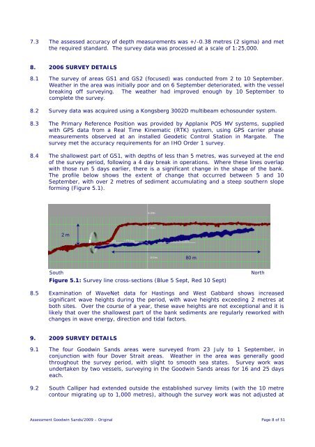
8.4 The shallowest part of <strong>GS1</strong>, with depths of less than 5 metres, was surveyed at the end<br />
of the survey period, following a 4 day break in operations. Where these lines overlap<br />
with those run 5 days earlier, there is a significant change in the shape of the bank.<br />
The profile below shows the extent of change that occurred between 5 and 10<br />
September, with over 2 metres of sediment accumulating and a steep southern slope<br />
forming (Figure 5.1).<br />
2 m<br />
80 m<br />
South<br />
Figure 5.1: Survey line cross-sections (Blue 5 Sept, Red 10 Sept)<br />
North<br />
8.5 Examination of WaveNet data for Hastings and West Gabbard shows increased<br />
significant wave heights during the period, with wave heights exceeding 2 metres at<br />
both sites. Over the course of a year, these wave heights are not exceptional and it is<br />
likely that over the shallowest part of the bank sediments are regularly reworked with<br />
changes in wave energy, direction and tidal factors.<br />
9. 2009 SURVEY DETAILS<br />
9.1 The four <strong>Goodwin</strong> <strong>Sands</strong> areas were surveyed from 23 July to 1 September, in<br />
conjunction with four Dover Strait areas. Weather in the area was generally good<br />
throughout the survey period, with slight to smooth sea states. Survey work was<br />
undertaken by two vessels, surveying in the <strong>Goodwin</strong> <strong>Sands</strong> areas for 16 and 25 days<br />
each.<br />
9.2 South Calliper had extended outside the established survey limits (with the 10 metre<br />
contour migrating up to 1,000 metres), although the survey work was not adjusted at<br />
Assessment <strong>Goodwin</strong> <strong>Sands</strong>/2009 – Original Page 8 of 51


