Download catalog - Saint-Tech
Download catalog - Saint-Tech
Download catalog - Saint-Tech

Create successful ePaper yourself
Turn your PDF publications into a flip-book with our unique Google optimized e-Paper software.
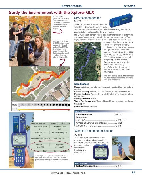
Aerial photograph in My<br />
World GIS software showing<br />
humidity index and<br />
wind chill from PASCO’s<br />
Weather/Anemometer<br />
Sensor. The size of the<br />
block indicates the humidity<br />
index and the color<br />
indicates the wind chill.<br />
Environmental<br />
Study the Environment with the Xplorer GLX<br />
Students use the<br />
Xplorer GLX, GPS Position<br />
Sensor and the Weather<br />
Anemometer to make environmental<br />
measurements<br />
around the perimeter<br />
of a park.<br />
GPSPositionSensor<br />
PS-2175<br />
Use PASCO’s GPS Position Sensor to<br />
collect GPS data simultaneously with<br />
other sensor measurements, automatically synching the data to<br />
your latitude, longitude, altitude, and velocity.<br />
The GPS Position sensor utilizes satellite triangulation to determine<br />
the sensor’s position and velocity in outdoor environments. The<br />
highly-sensitive receiver is able to track satellites even under tree<br />
canopies often found along rivers.<br />
The sensor provides latitude,<br />
longitude, horizontal speed, course<br />
over ground, altitude and the<br />
number of tracked satellites. LED<br />
indicators let the user know if the<br />
GPS Position sensor is currently<br />
computing position reports.<br />
Overlay sensor data on aerial<br />
photos and maps using<br />
My World GIS software (see<br />
pasco.com/myworld for more<br />
information).<br />
Aerial Photo and GPS position data, color-coded<br />
by number of satellites in fix, on a hike through<br />
dense forest in Costa Rica.<br />
Specifications<br />
Measures: Latitude, longitude, elevation, velocity (speed and bearing), number of<br />
satellites<br />
Position Accuracy: 10 meters, 2D RMS; 5 meters, 2D RMS, WAAS enabled<br />
Position Resolution: 2 meters, full Latitude/Longitude mode; 0.2 meters relative<br />
position mode<br />
Velocity Resolution: 0.1 m/s<br />
Time to First Fix (average): 42 sec, cold start; 38 sec, warm start; 1 sec, hot start<br />
Channels: 20<br />
Refresh Rate: Once per second<br />
Order Information:<br />
GPS Position Sensor.....................................................................PS-2175<br />
Recommended:<br />
XplorerGLX...........................................................................................PS-2002<br />
MyWorldGISSoftwareStudentLicense......................SE-7382C<br />
PASPORTSensorExtensionCable......................................PS-2500<br />
p.4<br />
<br />
<br />
Display digital readings of position data with your<br />
other measurements on the Xplorer GLX, or even<br />
graph latitude and longitude to track your movement.<br />
Weather/AnemometerSensor<br />
PS-2174<br />
The Weather/Anemometer Sensor<br />
measures wind speed and wind chill<br />
in addition to temperature, barometric<br />
pressure, relative<br />
and absolute<br />
humidity, and<br />
dew point.<br />
Order Information:<br />
Weather/Anemometer Sensor................................................PS-2174<br />
www.pasco.com/engineering<br />
61