Using Historic Landscape Characterisation
Using Historic Landscape Characterisation
Using Historic Landscape Characterisation

You also want an ePaper? Increase the reach of your titles
YUMPU automatically turns print PDFs into web optimized ePapers that Google loves.
<strong>Landscape</strong> Management<br />
The Type specific sections in the<br />
Lancashire HLC report contain a great<br />
deal of relevant information that<br />
becomes useful when a scheme is<br />
being put together. The example on the<br />
previous page outlines the features that<br />
are likely to be encountered and how<br />
they are best managed, and makes a<br />
clear statement about the need for<br />
assessment prior to schemes such as<br />
tree planting. Under ‘improve<br />
management’ it highlights the need for<br />
positive management, and lists some of<br />
the preferred means of achieving this.<br />
HLC therefore provides a sound basis<br />
for considering the location and scope of<br />
agri-environment schemes. It identifies<br />
general issues that need to be looked at<br />
in detail and interpreted alongside<br />
historic maps and specific SMR<br />
information about the proposed area.<br />
An example from Herefordshire<br />
demonstrates how HLC is being used to<br />
inform a Countryside Stewardship<br />
Scheme. In this case the area<br />
earmarked for inclusion was identified<br />
by the HLC as having modern character,<br />
which influenced the recommendations<br />
that were made.<br />
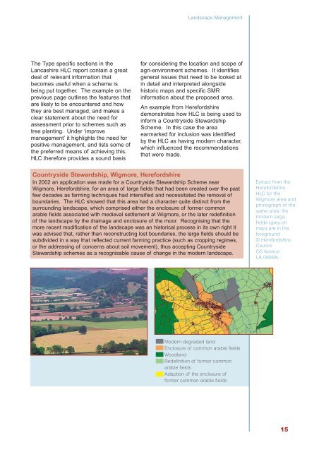
Countryside Stewardship, Wigmore, Herefordshire<br />
In 2002 an application was made for a Countryside Stewardship Scheme near<br />
Wigmore, Herefordshire, for an area of large fields that had been created over the past<br />
few decades as farming techniques had intensified and necessitated the removal of<br />
boundaries. The HLC showed that this area had a character quite distinct from the<br />
surrounding landscape, which comprised either the enclosure of former common<br />
arable fields associated with medieval settlement at Wigmore, or the later redefinition<br />
of the landscape by the drainage and enclosure of the moor. Recognising that the<br />
more recent modification of the landscape was an historical process in its own right it<br />
was advised that, rather than reconstructing lost boundaries, the large fields should be<br />
subdivided in a way that reflected current farming practice (such as cropping regimes,<br />
or the addressing of concerns about soil movement), thus accepting Countryside<br />
Stewardship schemes as a recognisable cause of change in the modern landscape.<br />
Extract from the<br />
Herefordshire<br />
HLC for the<br />
Wigmore area and<br />
photograph of the<br />
same area; the<br />
modern large<br />
fields (grey on<br />
map) are in the<br />
foreground<br />
© Herefordshire<br />
Council<br />
OS licence<br />
LA 09069L<br />
Modern degraded land<br />
Enclosure of common arable fields<br />
Woodland<br />
Redefinition of former common<br />
arable fields<br />
Adaption of the enclosure of<br />
former common arable fields<br />
15