Using Historic Landscape Characterisation
Using Historic Landscape Characterisation
Using Historic Landscape Characterisation

Create successful ePaper yourself
Turn your PDF publications into a flip-book with our unique Google optimized e-Paper software.
<strong>Using</strong> <strong>Historic</strong> <strong>Landscape</strong> <strong>Characterisation</strong><br />
Informing other work areas<br />
The range of other uses to which HLC<br />
is being put will continue to grow as new<br />
applications that recognise the value<br />
and need for historic landscape<br />
information are explored. One area that<br />
may well see further development in the<br />
future is the use of HLC in benchmarking<br />
for Indicators of Change.<br />
An example of this use is from the<br />
publication Lancashire Environment<br />
2002, which provides a comprehensive<br />
picture of the state of the county’s<br />
environment according to indicators<br />
ranging from water quality to traffic<br />
levels:<br />
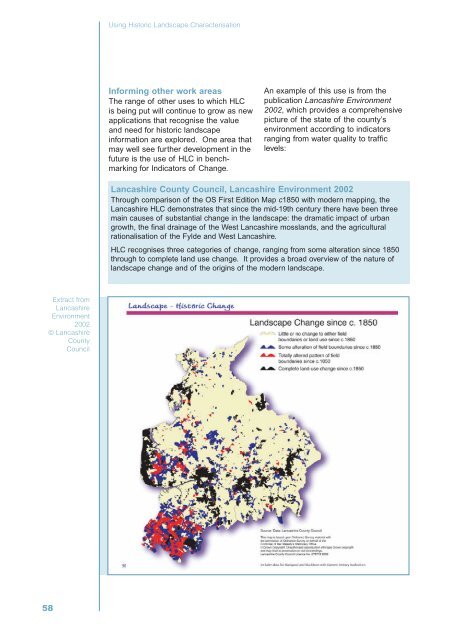
Lancashire County Council, Lancashire Environment 2002<br />
Through comparison of the OS First Edition Map c1850 with modern mapping, the<br />
Lancashire HLC demonstrates that since the mid-19th century there have been three<br />
main causes of substantial change in the landscape: the dramatic impact of urban<br />
growth, the final drainage of the West Lancashire mosslands, and the agricultural<br />
rationalisation of the Fylde and West Lancashire.<br />
HLC recognises three categories of change, ranging from some alteration since 1850<br />
through to complete land use change. It provides a broad overview of the nature of<br />
landscape change and of the origins of the modern landscape.<br />
Extract from<br />
Lancashire<br />
Environment<br />
2002<br />
© Lancashire<br />
County<br />
Council<br />
58