Using Historic Landscape Characterisation
Using Historic Landscape Characterisation
Using Historic Landscape Characterisation

Create successful ePaper yourself
Turn your PDF publications into a flip-book with our unique Google optimized e-Paper software.
Spatial Planning<br />
Development control<br />
In many local authorities, HLC mapping<br />
is routinely checked alongside the Sites<br />
and Monuments Record database<br />
(SMR) for responding to planning<br />
applications and enquires about the<br />
historic environment. For this work, HLC<br />
fills in the gaps that exist between the<br />
point data of the SMR, as well as<br />
providing a landscape context from<br />
which to appreciate site-specific<br />
information.<br />
Numerous examples have demonstrated<br />
the usefulness of HLC as a tool that can<br />
inform planning decisions, in particular<br />
for schemes that are large scale and<br />
rural in nature such as new housing<br />
estates, roads and pipelines. However,<br />
HLC has also begun to look at urban<br />
character and the built environment, and<br />
in the next few years it will become<br />
increasingly relevant for the assessment<br />
of planning proposals in towns and<br />
cities: in Cornwall, Lancashire and<br />
Merseyside, such work is currently<br />
being undertaken.<br />
Assessing the impact of<br />
development upon the landscape<br />
HLC is used to gauge the likely impact<br />
that development will have upon the<br />
landscape, by assessing whether<br />
proposals are in keeping with the<br />
historic character of the area and<br />
whether they have an impact on any of<br />
the key cultural attributes. Such<br />
information can be used to make an<br />
appropriate response to a planning<br />
application, whether in support,<br />
recommending refusal, or suggesting<br />
that it is amended to take into account<br />
the needs of the historic landscape.<br />
A few examples are set out below.<br />
Avebury<br />
© Jenny Nord<br />
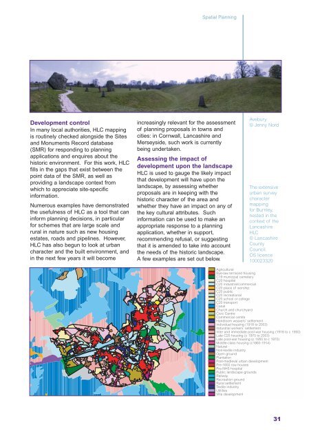
The extensive<br />
urban survey<br />
character<br />
mapping<br />
for Burnley,<br />
nested in the<br />
context of the<br />
Lancashire<br />
HLC<br />
© Lancashire<br />
County<br />
Council.<br />
OS licence<br />
100023320<br />
Agricultural<br />
Bye-law terraced housing<br />
C19 municipal cemetery<br />
C20 hospital<br />
C20 industrial/commercial<br />
C20 place of worship<br />
C20 public<br />
C20 recreational<br />
C20 school or college<br />
C20 transport<br />
Canal<br />
Church and churchyard<br />
Civic Centre<br />
Commercial centre<br />
Handloom weavers’ settlement<br />
Individual housing (1918 to 2003)<br />
Industrial workers’ settlement<br />
Inter and immediate post-war housing (1918 to c 1950)<br />
Late C20 housing (c 1970 to 2003)<br />
Late post-war housing (c 1950 to c 1970)<br />
Middle-class housing (c1860-1914)<br />
Natural<br />
Non-textile industry<br />
Open ground<br />
Plantation<br />
Post-medieval urban development<br />
Pre-1850 row houses<br />
Pre-NHS hospital<br />
Public landscape grounds<br />
Railway<br />
Recreation ground<br />
Rural settlement<br />
Textile industry<br />
Utilities<br />
Villa development<br />
31