

Brookvale West - Basingstoke and Deane Borough Council
Brookvale West - Basingstoke and Deane Borough Council
Brookvale West - Basingstoke and Deane Borough Council

You also want an ePaper? Increase the reach of your titles
YUMPU automatically turns print PDFs into web optimized ePapers that Google loves.
Conservation Area Appraisal<br />
The type of housing in the <strong>Brookvale</strong> <strong>West</strong> Conservation Area is similar to<br />
that of many towns <strong>and</strong> cities of their period. This was a reaction against<br />
the slum housing constructed in the factory towns earlier in the 19th<br />
century. The 1875 Public Health Act, <strong>and</strong> the Model by-laws that derived<br />
from the Act, set amenity <strong>and</strong> layout st<strong>and</strong>ards, which resulted in minimum<br />
street widths <strong>and</strong> open areas to the rear of dwellings.<br />
Within the established street pattern speculative building companies<br />
developed small numbers of plots on an ‘ad hoc’ basis. The result is a subtle<br />
variation in house design <strong>and</strong> detail.<br />
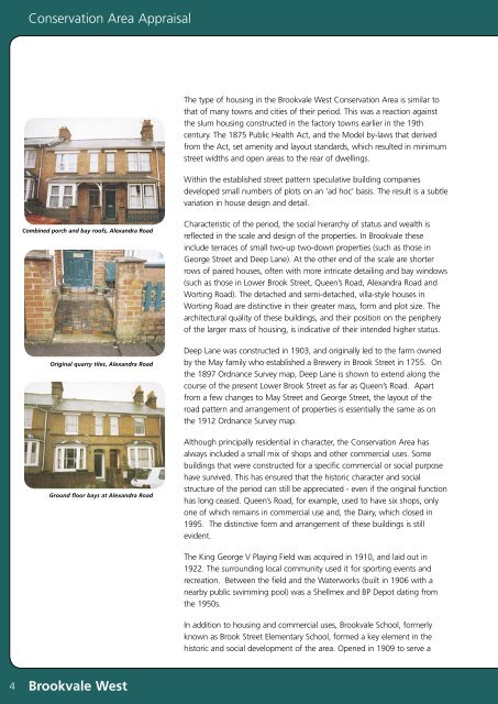
Combined porch <strong>and</strong> bay roofs, Alex<strong>and</strong>ra Road<br />
Original quarry tiles, Alex<strong>and</strong>ra Road<br />
Ground floor bays at Alex<strong>and</strong>ra Road<br />
Characteristic of the period, the social hierarchy of status <strong>and</strong> wealth is<br />
reflected in the scale <strong>and</strong> design of the properties. In <strong>Brookvale</strong> these<br />
include terraces of small two-up two-down properties (such as those in<br />
George Street <strong>and</strong> Deep Lane). At the other end of the scale are shorter<br />
rows of paired houses, often with more intricate detailing <strong>and</strong> bay windows<br />
(such as those in Lower Brook Street, Queen’s Road, Alex<strong>and</strong>ra Road <strong>and</strong><br />
Worting Road). The detached <strong>and</strong> semi-detached, villa-style houses in<br />
Worting Road are distinctive in their greater mass, form <strong>and</strong> plot size. The<br />
architectural quality of these buildings, <strong>and</strong> their position on the periphery<br />
of the larger mass of housing, is indicative of their intended higher status.<br />
Deep Lane was constructed in 1903, <strong>and</strong> originally led to the farm owned<br />
by the May family who established a Brewery in Brook Street in 1755. On<br />
the 1897 Ordnance Survey map, Deep Lane is shown to extend along the<br />
course of the present Lower Brook Street as far as Queen’s Road. Apart<br />
from a few changes to May Street <strong>and</strong> George Street, the layout of the<br />
road pattern <strong>and</strong> arrangement of properties is essentially the same as on<br />
the 1912 Ordnance Survey map.<br />
Although principally residential in character, the Conservation Area has<br />
always included a small mix of shops <strong>and</strong> other commercial uses. Some<br />
buildings that were constructed for a specific commercial or social purpose<br />
have survived. This has ensured that the historic character <strong>and</strong> social<br />
structure of the period can still be appreciated - even if the original function<br />
has long ceased. Queen’s Road, for example, used to have six shops, only<br />
one of which remains in commercial use <strong>and</strong>, the Dairy, which closed in<br />
1995. The distinctive form <strong>and</strong> arrangement of these buildings is still<br />
evident.<br />
The King George V Playing Field was acquired in 1910, <strong>and</strong> laid out in<br />
1922. The surrounding local community used it for sporting events <strong>and</strong><br />
recreation. Between the field <strong>and</strong> the Waterworks (built in 1906 with a<br />
nearby public swimming pool) was a Shellmex <strong>and</strong> BP Depot dating from<br />
the 1950s.<br />
In addition to housing <strong>and</strong> commercial uses, <strong>Brookvale</strong> School, formerly<br />
known as Brook Street Elementary School, formed a key element in the<br />
historic <strong>and</strong> social development of the area. Opened in 1909 to serve a<br />
4<br />
<strong>Brookvale</strong> <strong>West</strong>


