AIRS Level 1B Visible/Near-Infrared Channels ATBD - NASA's Earth ...
AIRS Level 1B Visible/Near-Infrared Channels ATBD - NASA's Earth ...
AIRS Level 1B Visible/Near-Infrared Channels ATBD - NASA's Earth ...
You also want an ePaper? Increase the reach of your titles
YUMPU automatically turns print PDFs into web optimized ePapers that Google loves.
<strong>AIRS</strong> <strong>Level</strong> 1b <strong>ATBD</strong> Part 2: Vis/<strong>Near</strong> IR <strong>Channels</strong><br />
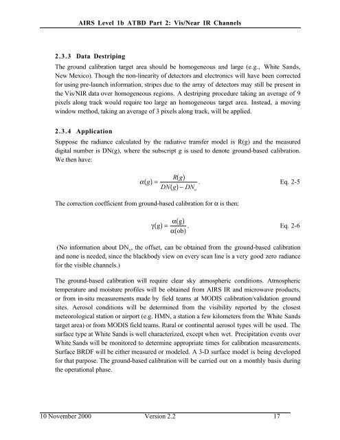
2.3.3 Data Destriping<br />
The ground calibration target area should be homogeneous and large (e.g., White Sands,<br />
New Mexico). Though the non-linearity of detectors and electronics will have been corrected<br />
for using pre-launch information, stripes due to the array of detectors may still be present in<br />
the Vis/NIR data over homogeneous regions. A destriping procedure taking an average of 9<br />
pixels along track would require too large an homogeneous target area. Instead, a moving<br />
window method, taking an average of 3 pixels along track, will be applied.<br />
2.3.4 Application<br />
Suppose the radiance calculated by the radiative transfer model is R(g) and the measured<br />
digital number is DN(g), where the subscript g is used to denote ground-based calibration.<br />
We then have:<br />
( ) =<br />
α g<br />
( )<br />
Rg<br />
. Eq. 2-5<br />
DN( g)−<br />
DN o<br />
The correction coefficient from ground-based calibration for α is then:<br />
γ( g) =<br />
( )<br />
( )<br />
α g<br />
. Eq. 2-6<br />
α ob<br />
(No information about DN o<br />
, the offset, can be obtained from the ground-based calibration<br />
and none is needed, since the blackbody view on every scan line is a very good zero radiance<br />
for the visible channels.)<br />
The ground-based calibration will require clear sky atmospheric conditions. Atmospheric<br />
temperature and moisture profiles will be obtained from <strong>AIRS</strong> IR and microwave products,<br />
or from in-situ measurements made by field teams at MODIS calibration/validation ground<br />
sites. Aerosol conditions will be determined from the visibility reported by the closest<br />
meteorological station or airport (e.g. HMN, a station a few kilometers from the White Sands<br />
target area) or from MODIS field teams. Rural or continental aerosol types will be used. The<br />
surface type at White Sands is well characterized, except when wet. Precipitation events over<br />
White Sands will be monitored to determine appropriate times for calibration measurements.<br />
Surface BRDF will be either measured or modeled. A 3-D surface model is being developed<br />
for that purpose. The ground-based calibration will be carried out on a monthly basis during<br />
the operational phase.<br />
10 November 2000 Version 2.2 17


