AIRS Level 1B Visible/Near-Infrared Channels ATBD - NASA's Earth ...
AIRS Level 1B Visible/Near-Infrared Channels ATBD - NASA's Earth ...
AIRS Level 1B Visible/Near-Infrared Channels ATBD - NASA's Earth ...

You also want an ePaper? Increase the reach of your titles
YUMPU automatically turns print PDFs into web optimized ePapers that Google loves.
<strong>AIRS</strong> <strong>Level</strong> 1b <strong>ATBD</strong> Part 2: Vis/<strong>Near</strong> IR <strong>Channels</strong><br />
1.0<br />
0.8<br />
0.6<br />
0.4<br />
0.2<br />
transmittance<br />
<strong>AIRS</strong> 1<br />
M 8 M 9<br />
0.0<br />
0.38 0.39 0.40 0.41 0.42 0.43 0.44 0.45<br />
1.0 transmittance<br />
0.8<br />
<strong>AIRS</strong> 2<br />
0.6<br />
0.4<br />
0.2<br />
0.0<br />
surface albedo<br />
water<br />
sand<br />
veget<br />
M1 M 14<br />
0.55 0.60 0.65 0.70 0.75<br />
1.0<br />
0.8<br />
0.6<br />
0.4<br />
0.2<br />
0.0<br />
1.0<br />
0.8<br />
0.6<br />
0.4<br />
0.2<br />
0.0<br />
<strong>AIRS</strong> 3<br />
M 15 M 2<br />
M 19<br />
0.70 0.80 0.90 1.00<br />
transmittance<br />
<strong>AIRS</strong> 4<br />
M 8<br />
M 3<br />
M 4<br />
M 1<br />
M 2<br />
M 15<br />
transmittance<br />
M 19<br />
0.4 0.6 0.8 1.0<br />
Wavelength (µm)<br />
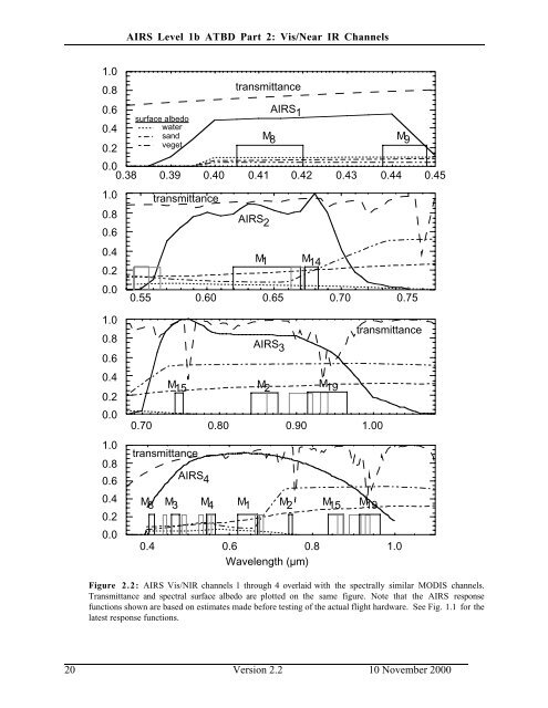
Figure 2.2: <strong>AIRS</strong> Vis/NIR channels 1 through 4 overlaid with the spectrally similar MODIS channels.<br />
Transmittance and spectral surface albedo are plotted on the same figure. Note that the <strong>AIRS</strong> response<br />
functions shown are based on estimates made before testing of the actual flight hardware. See Fig. 1.1 for the<br />
latest response functions.<br />
20 Version 2.2 10 November 2000