AIRS Level 1B Visible/Near-Infrared Channels ATBD - NASA's Earth ...
AIRS Level 1B Visible/Near-Infrared Channels ATBD - NASA's Earth ...
AIRS Level 1B Visible/Near-Infrared Channels ATBD - NASA's Earth ...

You also want an ePaper? Increase the reach of your titles
YUMPU automatically turns print PDFs into web optimized ePapers that Google loves.
<strong>AIRS</strong> <strong>Level</strong> 1b <strong>ATBD</strong> Part 2: Vis/<strong>Near</strong> IR <strong>Channels</strong><br />
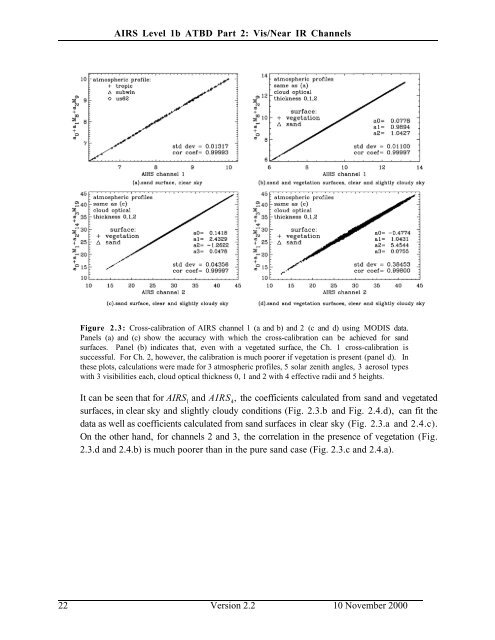
Figure 2.3: Cross-calibration of <strong>AIRS</strong> channel 1 (a and b) and 2 (c and d) using MODIS data.<br />
Panels (a) and (c) show the accuracy with which the cross-calibration can be achieved for sand<br />
surfaces. Panel (b) indicates that, even with a vegetated surface, the Ch. 1 cross-calibration is<br />
successful. For Ch. 2, however, the calibration is much poorer if vegetation is present (panel d). In<br />
these plots, calculations were made for 3 atmospheric profiles, 5 solar zenith angles, 3 aerosol types<br />
with 3 visibilities each, cloud optical thickness 0, 1 and 2 with 4 effective radii and 5 heights.<br />
It can be seen that for <strong>AIRS</strong> 1<br />
and <strong>AIRS</strong> 4<br />
, the coefficients calculated from sand and vegetated<br />
surfaces, in clear sky and slightly cloudy conditions (Fig. 2.3.b and Fig. 2.4.d), can fit the<br />
data as well as coefficients calculated from sand surfaces in clear sky (Fig. 2.3.a and 2.4.c).<br />
On the other hand, for channels 2 and 3, the correlation in the presence of vegetation (Fig.<br />
2.3.d and 2.4.b) is much poorer than in the pure sand case (Fig. 2.3.c and 2.4.a).<br />
22 Version 2.2 10 November 2000