National Meteorological Library and Archive Fact sheet 15 - Met Office
National Meteorological Library and Archive Fact sheet 15 - Met Office
National Meteorological Library and Archive Fact sheet 15 - Met Office

You also want an ePaper? Increase the reach of your titles
YUMPU automatically turns print PDFs into web optimized ePapers that Google loves.
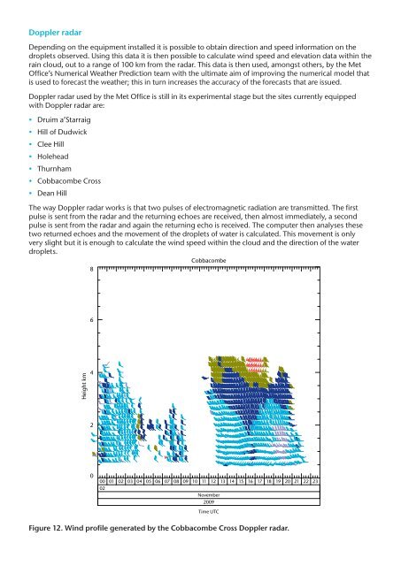
Doppler radar<br />
Depending on the equipment installed it is possible to obtain direction <strong>and</strong> speed information on the<br />
droplets observed. Using this data it is then possible to calculate wind speed <strong>and</strong> elevation data within the<br />
rain cloud, out to a range of 100 km from the radar. This data is then used, amongst others, by the <strong>Met</strong><br />
<strong>Office</strong>’s Numerical Weather Prediction team with the ultimate aim of improving the numerical model that<br />
is used to forecast the weather; this in turn increases the accuracy of the forecasts that are issued.<br />
Doppler radar used by the <strong>Met</strong> <strong>Office</strong> is still in its experimental stage but the sites currently equipped<br />
with Doppler radar are:<br />
• Druim a’Starraig<br />
• Hill of Dudwick<br />
• Clee Hill<br />
• Holehead<br />
• Thurnham<br />
• Cobbacombe Cross<br />
• Dean Hill<br />
The way Doppler radar works is that two pulses of electromagnetic radiation are transmitted. The first<br />
pulse is sent from the radar <strong>and</strong> the returning echoes are received, then almost immediately, a second<br />
pulse is sent from the radar <strong>and</strong> again the returning echo is received. The computer then analyses these<br />
two returned echoes <strong>and</strong> the movement of the droplets of water is calculated. This movement is only<br />
very slight but it is enough to calculate the wind speed within the cloud <strong>and</strong> the direction of the water<br />
droplets.<br />
Cobbacombe<br />
8<br />
6<br />
Height km<br />
4<br />
2<br />
0<br />
00 01 02 03 04 05 06 07 08 09 10 11 12 13 14 <strong>15</strong> 16 17 18 19 20 21 22 23<br />
02<br />
November<br />
2009<br />
Time UTC<br />
Figure 12. Wind profile generated by the Cobbacombe Cross Doppler radar.