National Meteorological Library and Archive Fact sheet 15 - Met Office
National Meteorological Library and Archive Fact sheet 15 - Met Office
National Meteorological Library and Archive Fact sheet 15 - Met Office

You also want an ePaper? Increase the reach of your titles
YUMPU automatically turns print PDFs into web optimized ePapers that Google loves.
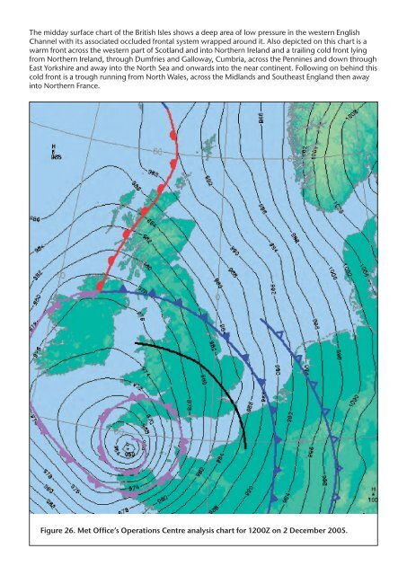
The midday surface chart of the British Isles shows a deep area of low pressure in the western English<br />
Channel with its associated occluded frontal system wrapped around it. Also depicted on this chart is a<br />
warm front across the western part of Scotl<strong>and</strong> <strong>and</strong> into Northern Irel<strong>and</strong> <strong>and</strong> a trailing cold front lying<br />
from Northern Irel<strong>and</strong>, through Dumfries <strong>and</strong> Galloway, Cumbria, across the Pennines <strong>and</strong> down through<br />
East Yorkshire <strong>and</strong> away into the North Sea <strong>and</strong> onwards into the near continent. Following on behind this<br />
cold front is a trough running from North Wales, across the Midl<strong>and</strong>s <strong>and</strong> Southeast Engl<strong>and</strong> then away<br />
into Northern France.<br />
Figure 26. <strong>Met</strong> <strong>Office</strong>’s Operations Centre analysis chart for 1200Z on 2 December 2005.