National Meteorological Library and Archive Fact sheet 15 - Met Office
National Meteorological Library and Archive Fact sheet 15 - Met Office
National Meteorological Library and Archive Fact sheet 15 - Met Office

Create successful ePaper yourself
Turn your PDF publications into a flip-book with our unique Google optimized e-Paper software.
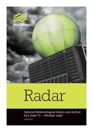
Radar imagery used in real-life weather forecasting<br />
Radar imagery is just one of the tools that a forecaster has at their disposal when analysing weather<br />
patterns in order to issue a forecast. For example, on the 2 December 2005 a vigorous depression<br />
approached the far southwest of Engl<strong>and</strong>. Using satellite imagery, it was possible to follow the cloud<br />
patterns associated with this depression but only when the rainfall radar was used was it possible to see<br />
exactly where the heaviest rain was falling <strong>and</strong> issue warnings as appropriate.<br />
metoffice.gov.uk<br />
©Crown copyright<br />
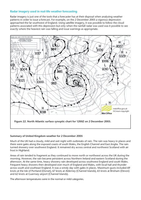
Figure 22. North Atlantic surface synoptic chart for 1200Z on 2 December 2005.<br />
Summary of United Kingdom weather for 2 December 2005<br />
Much of the UK had a cloudy, mild <strong>and</strong> wet night with outbreaks of rain. The rain was heavy in places <strong>and</strong><br />
there were gales along the exposed coasts of south Wales, the English Channel <strong>and</strong> East Anglia. The rain<br />
turned showery over southwest Engl<strong>and</strong>. It remained dry across central <strong>and</strong> northwest Scotl<strong>and</strong> with air<br />
frost in Highl<strong>and</strong>.<br />
Areas of rain tended to fragment as they continued to move north or northwest across the UK during the<br />
morning. However, the rain became persistent across Northern Irel<strong>and</strong> <strong>and</strong> eastern Scotl<strong>and</strong> during the<br />
afternoon. At the same time, heavy showery rain developed across southwest Engl<strong>and</strong> <strong>and</strong> south Wales.<br />
Frequent heavy showers then developed over much of Engl<strong>and</strong> <strong>and</strong> Wales, with local hail <strong>and</strong> thunder<br />
across south <strong>and</strong> southeast Engl<strong>and</strong>. It was a windy day with gales in places. Maximum gusts included 69<br />
knots at the Isle of Portl<strong>and</strong> (Dorset), 67 knots at Alderney (Channel Isl<strong>and</strong>s), 63 knots at Brixham (Devon)<br />
<strong>and</strong> 62 knots at Guernsey airport (Channel Isl<strong>and</strong>s).<br />
The afternoon temperatures were in the normal or mild categories.