National Meteorological Library and Archive Fact sheet 15 - Met Office
National Meteorological Library and Archive Fact sheet 15 - Met Office
National Meteorological Library and Archive Fact sheet 15 - Met Office

Create successful ePaper yourself
Turn your PDF publications into a flip-book with our unique Google optimized e-Paper software.
Interpreting radar imagery<br />
The radars do not receive echoes from tiny cloud particles, but only from the precipitation-sized droplets.<br />
Drizzle is generally too small to be reliably observed, unless close to the radar, but rain, snow <strong>and</strong> hail are<br />
all observed without difficulty.<br />
It is important to interpret the radar imagery in terms of the beam’s elevation <strong>and</strong> ‘width’ <strong>and</strong> the earth’s<br />
curvature. The latter, for example, means that echoes come from an increasingly higher level the further<br />
away precipitation is from the radar. Thus at a range of 100 km, the radar beam is being reflected from the<br />
raindrops in a cloud at a height of 1.5 km, but beneath that level rain may be falling from the cloud which<br />
the radar misses. For this <strong>and</strong> other reasons (listed below), the radar rainfall display may not fully represent<br />
the rainfall observed at the ground.<br />
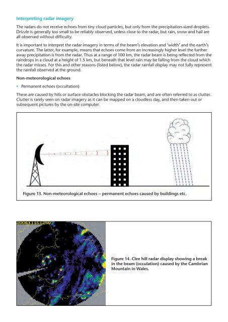
Non-meteorological echoes<br />
• Permanent echoes (occultation)<br />
These are caused by hills or surface obstacles blocking the radar beam, <strong>and</strong> are often referred to as clutter.<br />
Clutter is rarely seen on radar imagery as it can be mapped on a cloudless day, <strong>and</strong> then taken out or<br />
subsequent pictures by the on-site computer.<br />
Figure 13. Non-meteorological echoes – permanent echoes caused by buildings etc.<br />
Figure 14. Clee hill radar display showing a break<br />
in the beam (occulation) caused by the Cambrian<br />
Mountain in Wales.