National Meteorological Library and Archive Fact sheet 15 - Met Office
National Meteorological Library and Archive Fact sheet 15 - Met Office
National Meteorological Library and Archive Fact sheet 15 - Met Office

Create successful ePaper yourself
Turn your PDF publications into a flip-book with our unique Google optimized e-Paper software.
accumulations. Even with a network of radars, the screening effect of hills can make the detection of this<br />
orographic enhancement difficult, resulting in an under-estimate of the actual rainfall.<br />
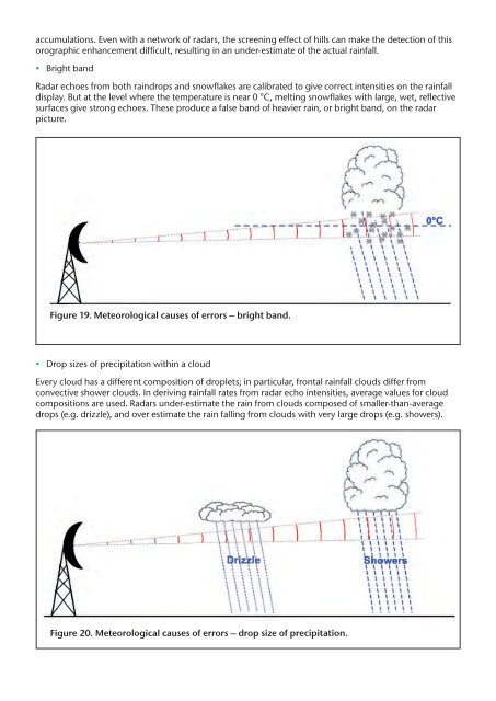
• Bright b<strong>and</strong><br />
Radar echoes from both raindrops <strong>and</strong> snowflakes are calibrated to give correct intensities on the rainfall<br />
display. But at the level where the temperature is near 0 °C, melting snowflakes with large, wet, reflective<br />
surfaces give strong echoes. These produce a false b<strong>and</strong> of heavier rain, or bright b<strong>and</strong>, on the radar<br />
picture.<br />
Figure 19. <strong><strong>Met</strong>eorological</strong> causes of errors – bright b<strong>and</strong>.<br />
• Drop sizes of precipitation within a cloud<br />
Every cloud has a different composition of droplets; in particular, frontal rainfall clouds differ from<br />
convective shower clouds. In deriving rainfall rates from radar echo intensities, average values for cloud<br />
compositions are used. Radars under-estimate the rain from clouds composed of smaller-than-average<br />
drops (e.g. drizzle), <strong>and</strong> over estimate the rain falling from clouds with very large drops (e.g. showers).<br />
Figure 20. <strong><strong>Met</strong>eorological</strong> causes of errors – drop size of precipitation.