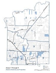
3.0 Land Use and Development - Town of Amherst
3.0 Land Use and Development - Town of Amherst
3.0 Land Use and Development - Town of Amherst

Create successful ePaper yourself
Turn your PDF publications into a flip-book with our unique Google optimized e-Paper software.
CREEK<br />
TONAWANDA<br />
RANSOM<br />
BLACK CREEK<br />
CREEK<br />
ELLICOTT<br />
.-, 990 .-, 290 BUFFALO-NIAGARA<br />
CREEK<br />
VILLAGE OF<br />
WILLAMSVILLE<br />
Generalized Existing Zoning<br />
LEGEND<br />
Suburban Agricultural<br />
Residential<br />
Single Family Residential<br />
Low Density Residential<br />
Medium Density Residential<br />
New Community District<br />
Planned Residential District<br />
Commercial - Non-Office<br />
Commercial - Office<br />
Community Facilities<br />
Industrial<br />
Municipal Boundary<br />
Parcel Boundary<br />
INTERNATIONAL AIRPORT<br />
Village <strong>of</strong> Williamsville<br />
Boundary<br />
New Community District<br />
Boundary<br />
Æ`<br />
Surface Water<br />
Body<br />
.-, 90<br />
SOURCE NOTES :<br />
FIGURE 3<br />
Original Source Data Provided by the <strong>Town</strong><br />
<strong>of</strong> <strong>Amherst</strong><br />
Zoning Data, September 2000<br />
This Zoning Map not <strong>of</strong>ficially adopted by the<br />
<strong>Amherst</strong> <strong>Town</strong> Board, Deed <strong>and</strong> other restrictions<br />
may apply to some parcels.<br />
For <strong>of</strong>ficial zoning information contact the<br />
<strong>Town</strong> <strong>of</strong> <strong>Amherst</strong> Building Department<br />
Map Compiled by URS Corporation 0<br />
Date: February, 2004<br />
N<br />
0.25 0.5 0.75<br />
Miles<br />
1 1.25