

YAVAPAI COUNTY, ARIZONA Federal Emergency ... - FEMA Region 9
YAVAPAI COUNTY, ARIZONA Federal Emergency ... - FEMA Region 9
YAVAPAI COUNTY, ARIZONA Federal Emergency ... - FEMA Region 9

Create successful ePaper yourself
Turn your PDF publications into a flip-book with our unique Google optimized e-Paper software.
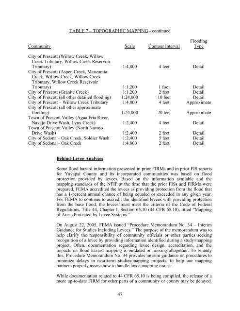
TABLE 7 – TOPOGRAPHIC MAPPING - continued<br />
Community Scale Contour Interval<br />
Flooding<br />
Type<br />
City of Prescott (Willow Creek, Willow<br />
Creek Tributary, Willow Creek Reservoir<br />
Tributary) 1:4,800 4 feet Detail<br />
City of Prescott (Aspen Creek, Manzanita<br />
Creek, Willow Creek, Willow Creek<br />
Tributary, Willow Creek Reservoir<br />
Tributary) 1:1,200 1 foot Detail<br />
City of Prescott (Granite Creek) 1:1,200 2 feet Detail<br />
City of Prescott (all other detailed flooding) 1:24,000 10 feet Detail<br />
City of Prescott – Willow Creek Tributary 1:4,800 4 feet Approximate<br />
City of Prescott (all other approximate<br />
flooding) 1:24,000 20 feet Approximate<br />
Town of Prescott Valley (Agua Fria River,<br />
Navajo Drive Wash, Lynx Creek) 1:2,400 4 feet Detail<br />
Town of Prescott Valley (North Navajo<br />
Drive Wash) 1:2,400 2 feet Detail<br />
City of Sedona – Oak Creek, Soldier Wash 1:2,400 5 feet Detail<br />
City of Sedona – Oak Creek 1:4,800 2 feet Detail<br />
Behind-Levee Analyses<br />
Some flood hazard information presented in prior FIRMs and in prior FIS reports<br />
for Yavapai County and its incorporated communities was based on flood<br />
protection provided by levees. Based on the information available and the<br />
mapping standards of the NFIP at the time that the prior FISs and FIRMs were<br />
prepared, <strong>FEMA</strong> accredited the levees as providing protection from the flood that<br />
has a 1-percent annual chance of being equaled or exceeded in any given year.<br />
For <strong>FEMA</strong> to continue to accredit the identified levees with providing protection<br />
from the base flood, the levees must meet the criteria of the Code of <strong>Federal</strong><br />
Regulations, Title 44, Chapter I, Section 65.10 (44 CFR 65.10), titled “Mapping<br />
of Areas Protected by Levee Systems.”<br />
On August 22, 2005, <strong>FEMA</strong> issued “Procedure Memorandum No. 34 – Interim<br />
Guidance for Studies Including Levees.” The purpose of the memorandum was to<br />
help clarify the responsibility of community officials or other parties seeking<br />
recognition of a levee by providing information identified during a study/mapping<br />
project. Often, documentation regarding levee design, accreditation, and the<br />
impacts on flood hazard mapping is outdated or missing altogether. To remedy<br />
this, Procedure Memorandum No. 34 provides interim guidance on procedures to<br />
minimize delays in near-term studies/mapping projects, to help our mapping<br />
partners properly assess how to handle levee mapping issues.<br />
While documentation related to 44 CFR 65.10 is being compiled, the release of a<br />
more up-to-date FIRM for other parts of a community or county may be delayed.<br />
47


