

YAVAPAI COUNTY, ARIZONA Federal Emergency ... - FEMA Region 9
YAVAPAI COUNTY, ARIZONA Federal Emergency ... - FEMA Region 9
YAVAPAI COUNTY, ARIZONA Federal Emergency ... - FEMA Region 9

Create successful ePaper yourself
Turn your PDF publications into a flip-book with our unique Google optimized e-Paper software.
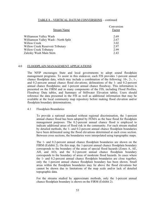
TABLE 8 – VERTICAL DATUM CONVERSIONS – continued<br />
Stream Name<br />
Conversion<br />
Factor<br />
Williamson Valley Wash 2.69<br />
Williamson Valley Wash - North Split 2.67<br />
Willow Creek 3.02<br />
Willow Creek Reservoir Tributary 2.97<br />
Willow Creek Tributary 2.99<br />
Zalesky Wash Main Stem 2.43<br />
4.0 FLOODPLAIN MANAGEMENT APPLICATIONS<br />
The NFIP encourages State and local governments to adopt sound floodplain<br />
management programs. To assist in this endeavor, each FIS provides 1-percent annual<br />
chance floodplain data, which may include a combination of the following: 10-, 2-, 1-,<br />
and 0.2-percent annual chance flood elevations; delineations of the 1- and 0.2-percent<br />
annual chance floodplains; and 1-percent annual chance floodway. This information is<br />
presented on the FIRM and in many components of the FIS, including Flood Profiles,<br />
Floodway Data tables, and Summary of Stillwater Elevation tables. Users should<br />
reference the data presented in the FIS as well as additional information that may be<br />
available at the local community map repository before making flood elevation and/or<br />
floodplain boundary determinations.<br />
4.1 Floodplain Boundaries<br />
To provide a national standard without regional discrimination, the 1-percent<br />
annual chance flood has been adopted by <strong>FEMA</strong> as the base flood for floodplain<br />
management purposes. The 0.2-percent annual chance flood is employed to<br />
indicate additional areas of flood risk in the community. For each stream studied<br />
by detailed methods, the 1- and 0.2-percent annual chance floodplain boundaries<br />
have been delineated using the flood elevations determined at each cross section.<br />
Between cross sections, the boundaries were interpolated using topographic maps.<br />
The 1- and 0.2-percent annual chance floodplain boundaries are shown on the<br />
FIRM (Exhibit 2). On this map, the 1-percent annual chance floodplain boundary<br />
corresponds to the boundary of the areas of special flood hazards (Zones A, AE,<br />
AH, and AO), and the 0.2-percent annual chance floodplain boundary<br />
corresponds to the boundary of areas of moderate flood hazards. In cases where<br />
the 1- and 0.2-percent annual chance floodplain boundaries are close together,<br />
only the 1-percent annual chance floodplain boundary has been shown. Small<br />
areas within the floodplain boundaries may lie above the flood elevations but<br />
cannot be shown due to limitations of the map scale and/or lack of detailed<br />
topographic data.<br />
For the streams studied by approximate methods, only the 1-percent annual<br />
chance floodplain boundary is shown on the FIRM (Exhibit 2).<br />
53


