Section 9 - Ground Transport Plan - Melbourne Airport
Section 9 - Ground Transport Plan - Melbourne Airport
Section 9 - Ground Transport Plan - Melbourne Airport

Create successful ePaper yourself
Turn your PDF publications into a flip-book with our unique Google optimized e-Paper software.
Due to its proximity to <strong>Melbourne</strong>’s freeway network,<br />
the airport is well serviced in terms of road access.<br />
High-capacity links within the airport support these<br />
systems; however, given high travel demands, congestion<br />
is a regular problem on both the internal and external road<br />
network during peak periods. Figure 9.1 summarises the<br />
<strong>Melbourne</strong> metropolitan transport system in the context<br />
of <strong>Melbourne</strong> <strong>Airport</strong>, including a broad understanding of<br />
the road and rail networks and bus systems.<br />
Over the last 10 years, <strong>Melbourne</strong> <strong>Airport</strong> has developed<br />
a management system based on a digital model of the<br />
road network. This system is called the <strong>Melbourne</strong> <strong>Airport</strong><br />
Landside Traffic Model and is used to test the existing<br />
road capacity and planned improvements. The Landside<br />
Traffic Model is a valuable tool for predicting and<br />
managing route congestion, and can identify locations<br />
or features that are causing traffic flow problems on the<br />
internal road network.<br />
Access to <strong>Melbourne</strong> <strong>Airport</strong> is provided from the<br />
Tullamarine Freeway, Melrose Drive and Sunbury Road. The<br />
main access to the airport is from the Tullamarine Freeway.<br />
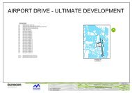
Figure 9.2 provides details of the arterial road network close<br />
to the airport, giving a visual understanding of the route<br />
options from the greater <strong>Melbourne</strong> freeway network.<br />
It is noted that the Tullamarine Freeway, from the M80<br />
Ring Road to <strong>Melbourne</strong> <strong>Airport</strong>, is part of the National<br />
Land <strong>Transport</strong> Network pursuant to the Nation Building<br />
Program (National Land <strong>Transport</strong> Network) Act 2009.<br />
Table 9.1: Existing External Road Network<br />
Road name Orientation Access Capacity<br />
Calder Freeway East–West CBD, CityLink Tollway,<br />
North and West, regional<br />
Victoria<br />
M80 Ring Road Orbital CBD, Metropolitan Ring<br />
Road, West, regional<br />
Victoria<br />
Tullamarine Freeway/<br />
CityLink<br />
A review of the internal road network using this model,<br />
along with stakeholder consultations, identified the<br />
following pressures:<br />
• Connections with the Tullamarine Freeway are<br />
approaching capacity. Traffic queues on Terminal<br />
Drive can affect the Tullamarine Freeway during daily<br />
peak periods.<br />
• Growth in residential areas will increase traffic<br />
volumes from the outer northern and western suburbs<br />
of metropolitan <strong>Melbourne</strong>. New road infrastructure,<br />
including connections to <strong>Melbourne</strong> <strong>Airport</strong>, will be<br />
required to cater for these trips.<br />
DRAFT<br />
6 lanes, two-way ✗<br />
4–6 lanes, two-way ✗<br />
Northwest–Southeast CBD, East 4–8 lanes, two-way.<br />
Express lane each<br />
direction between<br />
Brunswick Road and<br />
Bell Street<br />
Melrose Drive North–South Terminal Precinct from<br />
Tullamarine Freeway<br />
Keilor Park Drive North–South Sharps Road from<br />
M80 Ring Road<br />
<strong>Airport</strong> Drive Northwest–Southeast Sharps Road from<br />
M80 Ring Road<br />
Sharps Road East–West Links South Centre Road<br />
with Keilor Park Drive<br />
and Tullamarine Freeway<br />
Sunbury Road North–South North to Terminal<br />
Precinct, Tullamarine<br />
Freeway<br />
Direct access<br />
to <strong>Melbourne</strong><br />
<strong>Airport</strong><br />
✓<br />
2–6 lanes, two-way ✓<br />
4 lanes, two-way ✗<br />
4 lanes, two-way ✓<br />
4 lanes, two-way ✗<br />
2 lanes, two-way ✓<br />
104