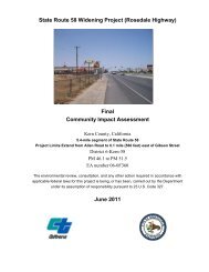
State Route 58 Widening Project - Bakersfield Freeways
State Route 58 Widening Project - Bakersfield Freeways
State Route 58 Widening Project - Bakersfield Freeways

Create successful ePaper yourself
Turn your PDF publications into a flip-book with our unique Google optimized e-Paper software.
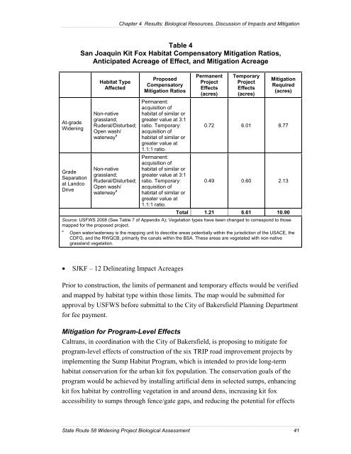
Chapter 4 Results: Biological Resources, Discussion of Impacts and Mitigation<br />
At-grade<br />
<strong>Widening</strong><br />
Grade<br />
Separation<br />
at Landco<br />
Drive<br />
Table 4<br />
San Joaquin Kit Fox Habitat Compensatory Mitigation Ratios,<br />
Anticipated Acreage of Effect, and Mitigation Acreage<br />
Habitat Type<br />
Affected<br />
Non-native<br />
grassland;<br />
Ruderal/Disturbed;<br />
Open wash/<br />
waterway a<br />
Non-native<br />
grassland;<br />
Ruderal/Disturbed;<br />
Open wash/<br />
waterway a<br />
Proposed<br />
Compensatory<br />
Mitigation Ratios<br />
Permanent:<br />
acquisition of<br />
habitat of similar or<br />
greater value at 3:1<br />
ratio. Temporary:<br />
acquisition of<br />
habitat of similar or<br />
greater value at<br />
1.1:1 ratio.<br />
Permanent:<br />
acquisition of<br />
habitat of similar or<br />
greater value at 3:1<br />
ratio. Temporary:<br />
acquisition of<br />
habitat of similar or<br />
greater value at<br />
1.1:1 ratio.<br />
Permanent<br />
<strong>Project</strong><br />
Effects<br />
(acres)<br />
Temporary<br />
<strong>Project</strong><br />
Effects<br />
(acres)<br />
Mitigation<br />
Required<br />
(acres)<br />
0.72 6.01 8.77<br />
0.49 0.60 2.13<br />
Total 1.21 6.61 10.90<br />
Source: USFWS 2008 (See Table 7 of Appendix A); Vegetation types have been changed to correspond to those<br />
mapped for the proposed project.<br />
a<br />
Open water/waterway is the mapping unit to describe areas potentially within the jurisdiction of the USACE, the<br />
CDFG, and the RWQCB, primarily the canals within the BSA. These areas are vegetated with non-native<br />
grassland vegetation.<br />
• SJKF – 12 Delineating Impact Acreages<br />
Prior to construction, the limits of permanent and temporary effects would be verified<br />
and mapped by habitat type within those limits. The map would be submitted for<br />
approval by USFWS before submittal to the City of <strong>Bakersfield</strong> Planning Department<br />
for fee payment.<br />
Mitigation for Program-Level Effects<br />
Caltrans, in coordination with the City of <strong>Bakersfield</strong>, is proposing to mitigate for<br />
program-level effects of construction of the six TRIP road improvement projects by<br />
implementing the Sump Habitat Program, which is intended to provide long-term<br />
habitat conservation for the urban kit fox population. The conservation goals of the<br />
program would be achieved by installing artificial dens in selected sumps, enhancing<br />
kit fox habitat by controlling vegetation in and around dens, increasing kit fox<br />
accessibility to sumps through fence/gate gaps, and reducing the potential for effects<br />
<strong>State</strong> <strong>Route</strong> <strong>58</strong> <strong>Widening</strong> <strong>Project</strong> Biological Assessment 41