- Page 1 and 2:
The Eleventh Regional Wheat Worksh
- Page 3 and 4:
CIMMYT® (www.cimmyt.cgiar.org) is
- Page 5 and 6:
Table a/Contents 105 Developing whe
- Page 7 and 8:
Table o/Contents 366 Delayed nitrog
- Page 9 and 10:
e>..... I Countries participating i
- Page 11 and 12:
Welcome on behalfo/CIMMYT Board a/T
- Page 13 and 14:
Welcome on behalfofCIMMYTBoard ofTr
- Page 15 and 16:
CIMMYT'S NE\V APPROACH TO ADDRESS W
- Page 17 and 18:
CIMMYT's Global Project 5 - Pfeiffe
- Page 19 and 20:
CIMMYT's Global Project 5 - Pfeiffe
- Page 21 and 22:
CIMMYT's Global Project 5 - Pfeiffe
- Page 23 and 24:
CIMMYT's Global Project 5 - Pfeiffe
- Page 25 and 26:
SOURCES OF VARIATION FOR GRAIN YIEL
- Page 27 and 28:
Sources ojvariation Jar grain yield
- Page 29 and 30:
Sources ofvariation for grain yield
- Page 31 and 32:
Sources ofvariation for grain yield
- Page 33 and 34:
Sources ofvariation for grain yield
- Page 35 and 36:
Germplasm enhancement through molec
- Page 37 and 38:
Germplasm enhancement through moiec
- Page 39 and 40:
Gennplasm enhancement through molec
- Page 41 and 42:
Germplasm enhancement through molec
- Page 43 and 44:
QUALITY OF ETHIOPIAN DURUM WHEAT CU
- Page 45 and 46:
Quality ofEthiopian durum wheat cul
- Page 47 and 48:
Quality ofEthiopian durum wheat cul
- Page 49 and 50:
Quality ofEthiopian durum wheat cul
- Page 51 and 52:
Quality ofEthiopian durum wheat cul
- Page 53 and 54:
Quality ofEthiopian durum wheat cul
- Page 55 and 56:
On-farm demonstration ofimproved du
- Page 57 and 58:
On-farm demonstration ofimproved du
- Page 59 and 60:
Identification o/Ethiopian wheat cu
- Page 61 and 62:
Identification ofEthiopian wheat cu
- Page 63 and 64:
Identification ofEthiopian wheat cu
- Page 65 and 66:
Identification ofEthiopian wheat cu
- Page 67 and 68:
Identification ojEthiopian wheat cu
- Page 69 and 70:
GENETIC IMPROVEMENT IN GRAIN YIELD
- Page 71 and 72:
Genetic improvement in wheat grain
- Page 73 and 74:
Genetic improvement in wheat grain
- Page 75 and 76:
(;p.np.tir. imnrovp.mp.nl in WhP.fl
- Page 77 and 78:
Increasing yield potential for marg
- Page 79 and 80:
Increasing yield potentialfor margi
- Page 81 and 82:
Increasing yield potentialfor margi
- Page 83 and 84:
Increasing yield potential for marg
- Page 85 and 86:
Increasing yield potential for marg
- Page 87 and 88:
BREAD WHEAT YIELD STABILITY ANI) EN
- Page 89 and 90:
Bread wheat yield stability and env
- Page 91 and 92:
Bread wheat yield stability and env
- Page 93 and 94:
Bread wheat yield stability and env
- Page 95 and 96:
Bread wheat yield stability and env
- Page 97 and 98:
Milling and baking quality ofEthiop
- Page 99 and 100:
Milling and baking quality ofEthiop
- Page 101 and 102:
Milling and baking quality ofEthiop
- Page 103 and 104:
Milling and baking quality ofEthiop
- Page 105 and 106:
Milling and baking quality ofEthiop
- Page 107 and 108:
Response ofbread wheat genotypes to
- Page 109 and 110:
Response ofbread wheat genotypes to
- Page 111 and 112:
Response ofbread wheat genotypes to
- Page 113 and 114:
Response o/bread wheat genotypes to
- Page 115 and 116:
Developing wheat varieties for drou
- Page 117 and 118:
Developing wheat varieties for drou
- Page 119 and 120:
Developing wheat varieties for drou
- Page 121 and 122:
MILLING AND BAKING QUALITY OF SOUT
- Page 123 and 124:
Milling and baking quality ofSouth
- Page 125 and 126:
Milling and baking quality ofSouth
- Page 127 and 128:
Milling and baking quality ofSou th
- Page 129 and 130:
,_._.__.__.- -- ----- -------------
- Page 131 and 132:
Response o/wheat genotypes to sowin
- Page 133 and 134:
Response ofwheat genotypes to sowin
- Page 135 and 136:
Response ofwheat genotypes to sowin
- Page 137 and 138:
Response ofwheat genotypes to sowin
- Page 139 and 140:
Mixtures offour wheat cultivars in
- Page 141 and 142:
Mixtures offour wheat cuttivars in
- Page 143 and 144:
THE ASSESSMENT AND SIGNIFICANCE OF
- Page 145 and 146:
Assessment a/pathogenic variability
- Page 147 and 148:
Assessment o/pathogenic variability
- Page 149 and 150:
Assessment ofpathogenic variability
- Page 151 and 152:
Assessment a/pathogenic variability
- Page 153 and 154:
SOURCES AND GENETIC BASIS OF VARIAB
- Page 155 and 156:
Sources ofvariability ofgenes for y
- Page 157 and 158:
Sources ofvariability ofgenes for y
- Page 159 and 160:
Sources ofvariability ofgenes for y
- Page 161 and 162:
PERFORMANCE OF FOUR NEW LEAF RUST R
- Page 163 and 164:
Performance offour new leafrust res
- Page 165 and 166:
Performance offour new leafrust res
- Page 167 and 168:
Performance offour new leafrust res
- Page 169 and 170:
HOST RANGE OF WHEAT STEM RUST IN ET
- Page 171 and 172:
Host range ofwheat stem rnst in Eth
- Page 173 and 174:
STABILITY OF STEM RUST RESISTANCE
- Page 175 and 176: Stability ofstem rust resistance in
- Page 177 and 178: Stability ofstem rust resistance in
- Page 179 and 180: Field response o/bread wheat genoty
- Page 181 and 182: Field response o/bread wheat genoty
- Page 183 and 184: Field response ofbread wheat genoty
- Page 185 and 186: Field response o/bread wheat genoty
- Page 187 and 188: Field response a/bread wheat genoty
- Page 189 and 190: Field response o/bread wheat genoty
- Page 191 and 192: Field response o/bread wheat genoty
- Page 193 and 194: Necessary to app~y insecticides to
- Page 195 and 196: Necessary to apply insecticides to
- Page 197 and 198: Necessary to apply insecticides to
- Page 199 and 200: RUSSIAN WHEAT APHID RESISTANT WHEAT
- Page 201 and 202: Integrated control using Russian wh
- Page 203 and 204: Integrated control using Russian wh
- Page 205 and 206: Development oflinear equations for
- Page 207 and 208: Development oflinear equations for
- Page 209 and 210: Development oflinear equations for
- Page 211 and 212: Development oflinear equations for
- Page 213 and 214: Development oflinear equations for
- Page 215 and 216: Development oflinear equations for
- Page 217 and 218: BREEDING FOR DISEASE RESISTANCE IN
- Page 219 and 220: Breeding f or disease resistance in
- Page 221 and 222: Breedingfor disease resistance in w
- Page 223 and 224: Breedingfor disease resistance in w
- Page 225: SPATIAL TOOLS FOR WHEAT RESEARCH I
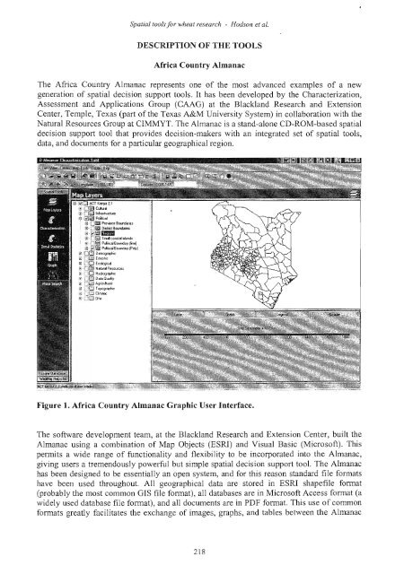
- Page 229 and 230: Spatial tools for wheat research -
- Page 231 and 232: Spatial tools for wheat research -
- Page 233 and 234: Spatial toolsjor wheat research - H
- Page 235 and 236: Spatial tools for wheat research -
- Page 237 and 238: Spatial tools for wheat research -
- Page 239 and 240: Response ofsome durum wheat landrac
- Page 241 and 242: Response a/some durum wheat landrac
- Page 243 and 244: Response ofsome durum wheat landrac
- Page 245 and 246: Response ofsome durum wheat landrac
- Page 247 and 248: Response ofsome durum wheat landrac
- Page 249 and 250: Agronomic and economic evaluation o
- Page 251 and 252: Agronomic and economic evaluation o
- Page 253 and 254: Agronomic and economic evaluation o
- Page 255 and 256: Agronomic and economic evaluation o
- Page 257 and 258: Agronomic and economic evaluation o
- Page 259 and 260: Agronomic and economic evaluation o
- Page 261 and 262: Agronomic and economic evaluation o
- Page 263 and 264: Effects ofsoil waterlogging on conc
- Page 265 and 266: Effects ofsoil waterlogging on conc
- Page 267 and 268: Effects a/soil waterlogging on conc
- Page 269 and 270: Effects ofsoil waterlogging on conc
- Page 271 and 272: Effects ojsoil waterlogging on conc
- Page 273 and 274: EFFECT OF CROP ROTATION AND FERTILI
- Page 275 and 276: Effect ofcrop rotation andfertilize
- Page 277 and 278:
Effect ofcrop rotation and fertiliz
- Page 279 and 280:
Effect ofcrop rotation and fertiliz
- Page 281 and 282:
Effect ofcrop rotation and fertiliz
- Page 283 and 284:
Effect ofcrop rotation andfertilize
- Page 285 and 286:
Effects oftillage and cropping sequ
- Page 287 and 288:
Effects oftillage and cropping sequ
- Page 289 and 290:
Effects oftillage and cropping sequ
- Page 291 and 292:
Effects oftillage and cropping sequ
- Page 293 and 294:
Effects oftillage and cropping sequ
- Page 295 and 296:
Effects oftillage and cropping sequ
- Page 297 and 298:
Effects oftillage and cropping sequ
- Page 299 and 300:
Effects oftillage and cropping sequ
- Page 301 and 302:
Survey ofweed community structure -
- Page 303 and 304:
Survey ofweed community structure -
- Page 305 and 306:
Survey ofweed community structure -
- Page 307 and 308:
Survey ofweed community stntcture -
- Page 309 and 310:
Survey ofweed community structure -
- Page 311 and 312:
EVALUATION OF HERBICIDES FOR THE CO
- Page 313 and 314:
Evaluation ofherbicides for the con
- Page 315 and 316:
Evaluation ofherbicides for the con
- Page 317 and 318:
Evaluation ofherbicides for the con
- Page 319 and 320:
Effects ofsurface drainage methods
- Page 321 and 322:
Effects ofsurface drainage methods
- Page 323 and 324:
Effects ofsurface drainage methods
- Page 325 and 326:
CROP ROTATION EFFECTS ON GRAIN YIEL
- Page 327 and 328:
Crop rotation effects on grain yiel
- Page 329 and 330:
Crop rotation effects on grain yiel
- Page 331 and 332:
Crop rotation effects on grain yiel
- Page 333 and 334:
Crop rotation effects on grain yiel
- Page 335 and 336:
Impact ofcropping sequence and fert
- Page 337 and 338:
Impact ofcropping sequence and fert
- Page 339 and 340:
Impact ofcropping sequence and fert
- Page 341 and 342:
Impact ofcropping sequence and fert
- Page 343 and 344:
Impact ofcropping sequence and fert
- Page 345 and 346:
THE INTRODUCTION OF DISEASE AND PES
- Page 347 and 348:
Introduction ofdisease and pest res
- Page 349 and 350:
Introduction ofdisease and pest res
- Page 351 and 352:
Reducing mechanical harvesting loss
- Page 353 and 354:
Reducing mechanical harvesting loss
- Page 355 and 356:
Reducing mechanical harvesting loss
- Page 357 and 358:
Effects ofcrop rotation, tillage me
- Page 359 and 360:
Effects ofcrop rotation, tillage me
- Page 361 and 362:
ON-FARM EVALUATION OF THE RESPONSE
- Page 363 and 364:
Response offour bread wheat varieti
- Page 365 and 366:
Response offour bread wheat varieti
- Page 367 and 368:
Response offour bread wheat varieti
- Page 369 and 370:
TIMING NITROGEN APPLICATION TO ENHA
- Page 371 and 372:
Timing N application to enhance whe
- Page 373 and 374:
Timing N application to enhance whe
- Page 375 and 376:
DELAYED NITROGEN APPLICATION AND LA
- Page 377 and 378:
Delayed N application and late till
- Page 379 and 380:
RESPONSE OF WEED INFESTATION AND GR
- Page 381 and 382:
Response ofweed infestation and gra
- Page 383 and 384:
Response ofweed infestation and gra
- Page 385 and 386:
Response ofweed infestation and gra
- Page 387 and 388:
Response ofweed infestation and gra
- Page 389 and 390:
FARMER PARTICIPATORY EVALUATION OF
- Page 391 and 392:
Farmer participatory evaluation ofb
- Page 393 and 394:
Farmer participatory evaluation o/b
- Page 395 and 396:
Farmer participatory evaluation ofb
- Page 397 and 398:
Farmer participatory evaluation o/b
- Page 399 and 400:
Farmer participatory evaluation o/b
- Page 401 and 402:
Client oriented research approach t
- Page 403 and 404:
Client oriented research approach t
- Page 405 and 406:
Economics offertilizer use on durum
- Page 407 and 408:
Economics offertilizer use on durum
- Page 409 and 410:
Economics offertilizer use on durum
- Page 411 and 412:
Economics oJJertilizer use on durom
- Page 413 and 414:
On-farm analysis ofdurum wheat prod
- Page 415 and 416:
On-farm analysis ofdurum wheat prod
- Page 417 and 418:
On-farm analysis ofdurum wheat prod
- Page 419 and 420:
On-farm analysis ofdurum wheat prod
- Page 421 and 422:
A study o/the adoption o/bread whea
- Page 423 and 424:
A study ofthe adoption ofbread whea
- Page 425 and 426:
A study ofthe adoption ofbread whea
- Page 427 and 428:
A study ofthe adoption ofbread whea
- Page 429 and 430:
A study ofthe adoption ofbread whea
- Page 431 and 432:
A study ofthe adoption ofbread whea
- Page 433 and 434:
A study ofthe adoption ofbread whea
- Page 435 and 436:
A study ofthe adoption ofbread whea
- Page 437 and 438:
Farmer participatory evaluation o/b
- Page 439 and 440:
Farmer participatory evaluation ofb
- Page 441 and 442:
Farmer participatory evaluation ofb
- Page 443 and 444:
Farmer participatory evaluation o/b
- Page 445 and 446:
Eleventh Regional Wheat Workshop Pa