PHOTOMOD VectOr (raster images processing) - Racurs
PHOTOMOD VectOr (raster images processing) - Racurs
PHOTOMOD VectOr (raster images processing) - Racurs
Create successful ePaper yourself
Turn your PDF publications into a flip-book with our unique Google optimized e-Paper software.
<strong>PHOTOMOD</strong><br />
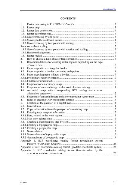
CONTENTS<br />
1. Raster <strong>processing</strong> in <strong>PHOTOMOD</strong> <strong>VectOr</strong> ..........................................................3<br />
1.1. Raster map.............................................................................................................3<br />
1.2. Raster data conversion...........................................................................................4<br />
1.3. Raster georeferencing............................................................................................4<br />
1.3.1. Georeferencing by one point. ................................................................................4<br />
1.3.2. Moving to the southwest corner. ...........................................................................4<br />
1.3.3. Georeferencing by two points with scaling...........................................................5<br />
Rotation without scaling. ................................................................................................5<br />
1.3.5. Georeferencing by two points with rotation and scaling.......................................5<br />
1.3.6. Horizontal alignment.............................................................................................6<br />
1.4. Raster region..........................................................................................................6<br />
2. How to choose a type of <strong>raster</strong> transformation......................................................6<br />
3. Recommendations for creating <strong>raster</strong> regions depending on the type<br />
of source data.........................................................................................................6<br />
3.1. Paper map with a rectangular border.....................................................................6<br />
3.2. Paper map with a border containing arch points. ..................................................9<br />
3.3. Paper map fragments without a border..................................................................9<br />
3.3.1. Preliminary <strong>raster</strong> orientation..............................................................................10<br />
3.3.2. Final <strong>raster</strong> orientation.........................................................................................10<br />
3.4. Fragments of an arbitrary image..........................................................................10<br />
3.5. Fragment of an aerial image with a control points catalog. ................................11<br />
3.6. An aerial image with corresponding GCP catalog and exterior<br />
orientation parameters. ........................................................................................12<br />
3.8. Fragment of an aerial image and a corresponding vector map............................13<br />
4. Rules of creating GCP coordinates catalog.........................................................14<br />
5. Creation of the passport of a digital map.............................................................14<br />
5.1. General info.........................................................................................................14<br />
5.2. Copy information from the passport of an existing map.....................................15<br />
5.3. Entering map passport information .....................................................................15<br />
5.3.1. Data, related to the work region. .........................................................................15<br />
5.3.2. Map sheet related data.........................................................................................16<br />
5.4. Creating a map passport, step by step. ................................................................17<br />
5.4.1. Creating a topographic map.................................................................................17<br />
5.4.2. Creating a geographic map..................................................................................17<br />
5.5. Nomenclature. .....................................................................................................17<br />
5.5.1. Nomenclature of topographic maps.....................................................................17<br />
5.5.2 Nomenclature of geographic maps. .....................................................................19<br />
Appendix 1. GCP coordinates catalog format (coordinate system<br />
Pulkovo1942 (Gauss-Kruger)) ............................................................................24<br />
Appendix 2. GCP coordinates catalog format (geodetic coordinate system) ...............25<br />
Appendix 3. GCP coordinates catalog format (transformation by the<br />
exterior orientation parameters) ..........................................................................26<br />
© 2009 2


