PHOTOMOD VectOr (raster images processing) - Racurs
PHOTOMOD VectOr (raster images processing) - Racurs
PHOTOMOD VectOr (raster images processing) - Racurs

You also want an ePaper? Increase the reach of your titles
YUMPU automatically turns print PDFs into web optimized ePapers that Google loves.
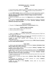
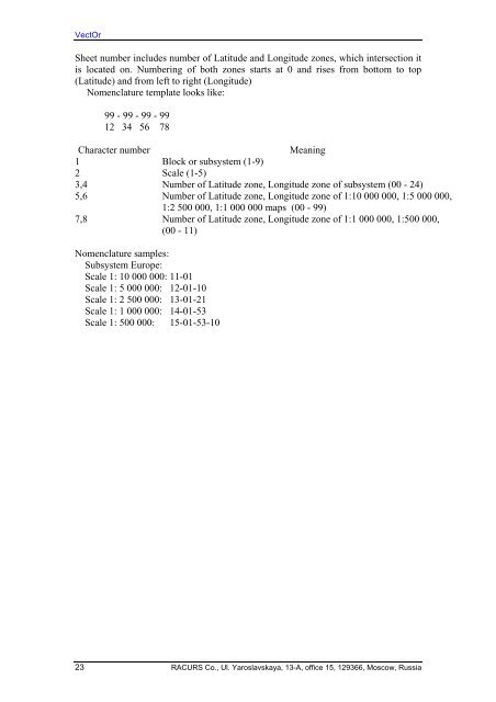
<strong>VectOr</strong><br />
Sheet number includes number of Latitude and Longitude zones, which intersection it<br />
is located on. Numbering of both zones starts at 0 and rises from bottom to top<br />
(Latitude) and from left to right (Longitude)<br />
Nomenclature template looks like:<br />
99 - 99 - 99 - 99<br />
12 34 56 78<br />
Character number<br />
Meaning<br />
1 Block or subsystem (1-9)<br />
2 Scale (1-5)<br />
3,4 Number of Latitude zone, Longitude zone of subsystem (00 - 24)<br />
5,6 Number of Latitude zone, Longitude zone of 1:10 000 000, 1:5 000 000,<br />
1:2 500 000, 1:1 000 000 maps (00 - 99)<br />
7,8 Number of Latitude zone, Longitude zone of 1:1 000 000, 1:500 000,<br />
(00 - 11)<br />
Nomenclature samples:<br />
Subsystem Europe:<br />
Scale 1: 10 000 000: 11-01<br />
Scale 1: 5 000 000: 12-01-10<br />
Scale 1: 2 500 000: 13-01-21<br />
Scale 1: 1 000 000: 14-01-53<br />
Scale 1: 500 000: 15-01-53-10<br />
23 RACURS Co., Ul. Yaroslavskaya, 13-A, office 15, 129366, Moscow, Russia