PHOTOMOD VectOr (raster images processing) - Racurs
PHOTOMOD VectOr (raster images processing) - Racurs
PHOTOMOD VectOr (raster images processing) - Racurs

You also want an ePaper? Increase the reach of your titles
YUMPU automatically turns print PDFs into web optimized ePapers that Google loves.
<strong>PHOTOMOD</strong><br />
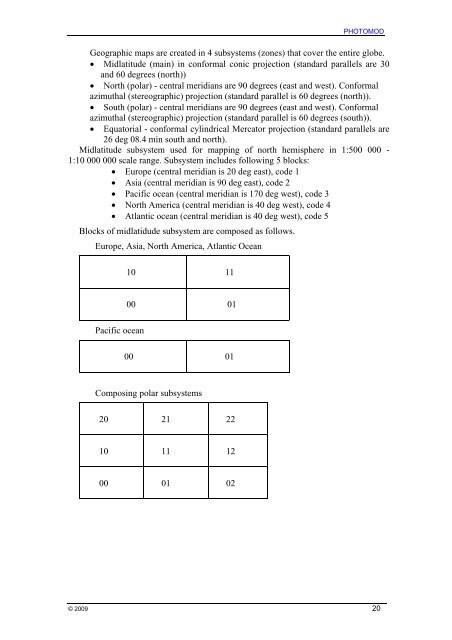
Geographic maps are created in 4 subsystems (zones) that cover the entire globe.<br />
• Midlatitude (main) in conformal conic projection (standard parallels are 30<br />
and 60 degrees (north))<br />
• North (polar) - central meridians are 90 degrees (east and west). Conformal<br />
azimuthal (stereographic) projection (standard parallel is 60 degrees (north)).<br />
• South (polar) - central meridians are 90 degrees (east and west). Conformal<br />
azimuthal (stereographic) projection (standard parallel is 60 degrees (south)).<br />
• Equatorial - conformal cylindrical Mercator projection (standard parallels are<br />
26 deg 08.4 min south and north).<br />
Midlatitude subsystem used for mapping of north hemisphere in 1:500 000 -<br />
1:10 000 000 scale range. Subsystem includes following 5 blocks:<br />
• Europe (central meridian is 20 deg east), code 1<br />
• Asia (central meridian is 90 deg east), code 2<br />
• Pacific ocean (central meridian is 170 deg west), code 3<br />
• North America (central meridian is 40 deg west), code 4<br />
• Atlantic ocean (central meridian is 40 deg west), code 5<br />
Blocks of midlatidude subsystem are composed as follows.<br />
Europe, Asia, North America, Atlantic Ocean<br />
10 11<br />
00 01<br />
Pacific ocean<br />
00 01<br />
Composing polar subsystems<br />
20 21 22<br />
10 11 12<br />
00 01 02<br />
© 2009 20