Landscape Project Version 3.1 - State of New Jersey
Landscape Project Version 3.1 - State of New Jersey
Landscape Project Version 3.1 - State of New Jersey

Create successful ePaper yourself
Turn your PDF publications into a flip-book with our unique Google optimized e-Paper software.
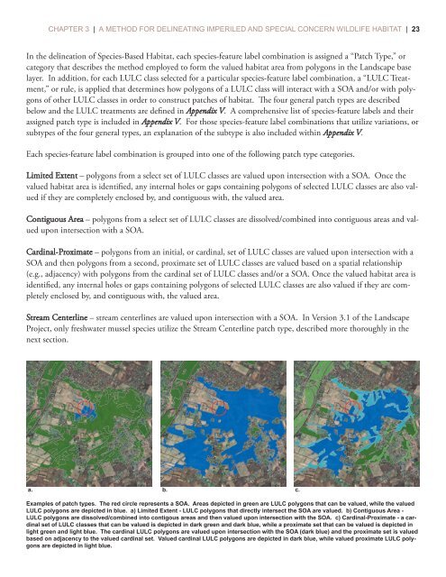
CHAPTER 3 | A METHOD FOR DELINEATING IMPERILED AND SPECIAL CONCERN WILDLIFE HABITAT | 23In the delineation <strong>of</strong> Species-Based Habitat, each species-feature label combination is assigned a “Patch Type,” orcategory that describes the method employed to form the valued habitat area from polygons in the <strong>Landscape</strong> baselayer. In addition, for each LULC class selected for a particular species-feature label combination, a “LULC Treatment,”or rule, is applied that determines how polygons <strong>of</strong> a LULC class will interact with a SOA and/or with polygons<strong>of</strong> other LULC classes in order to construct patches <strong>of</strong> habitat. e four general patch types are describedbelow and the LULC treatments are defined in Appendix V. A comprehensive list <strong>of</strong> species-feature labels and theirassigned patch type is included in Appendix V. For those species-feature label combinations that utilize variations, orsubtypes <strong>of</strong> the four general types, an explanation <strong>of</strong> the subtype is also included within Appendix V.Each species-feature label combination is grouped into one <strong>of</strong> the following patch type categories.Limited Extent – polygons from a select set <strong>of</strong> LULC classes are valued upon intersection with a SOA. Once thevalued habitat area is identified, any internal holes or gaps containing polygons <strong>of</strong> selected LULC classes are also valuedif they are completely enclosed by, and contiguous with, the valued area.Contiguous Area – polygons from a select set <strong>of</strong> LULC classes are dissolved/combined into contiguous areas and valuedupon intersection with a SOA.Cardinal-Proximate – polygons from an initial, or cardinal, set <strong>of</strong> LULC classes are valued upon intersection with aSOA and then polygons from a second, proximate set <strong>of</strong> LULC classes are valued based on a spatial relationship(e.g., adjacency) with polygons from the cardinal set <strong>of</strong> LULC classes and/or a SOA. Once the valued habitat area isidentified, any internal holes or gaps containing polygons <strong>of</strong> selected LULC classes are also valued if they are completelyenclosed by, and contiguous with, the valued area.Stream Centerline – stream centerlines are valued upon intersection with a SOA. In <strong>Version</strong> <strong>3.1</strong> <strong>of</strong> the <strong>Landscape</strong><strong>Project</strong>, only freshwater mussel species utilize the Stream Centerline patch type, described more thoroughly in thenext section.a. b. c.Examples <strong>of</strong> patch types. The red circle represents a SOA. Areas depicted in green are LULC polygons that can be valued, while the valuedLULC polygons are depicted in blue. a) Limited Extent - LULC polygons that directly intersect the SOA are valued. b) Contiguous Area -LULC polygons are dissolved/combined into contigous areas and then valued upon intersection with the SOA. c) Cardinal-Proximate - a cardinalset <strong>of</strong> LULC classes that can be valued is depicted in dark green and dark blue, while a proximate set that can be valued is depicted inlight green and light blue. The cardinal LULC polygons are valued upon intersection with the SOA (dark blue) and the proximate set is valuedbased on adjacency to the valued cardinal set. Valued cardinal LULC polygons are depicted in dark blue, while valued proximate LULC polygonsare depicted in light blue.