Landscape Project Version 3.1 - State of New Jersey
Landscape Project Version 3.1 - State of New Jersey
Landscape Project Version 3.1 - State of New Jersey

Create successful ePaper yourself
Turn your PDF publications into a flip-book with our unique Google optimized e-Paper software.
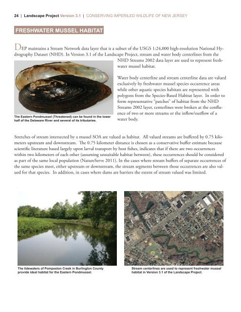
24 | <strong>Landscape</strong> <strong>Project</strong> <strong>Version</strong> <strong>3.1</strong> | CONSERVING IMPERILED WILDLIFE OF NEW JERSEYFRESHWATER MUSSEL HABITATDEP maintains a Stream Network data layer that is a subset <strong>of</strong> the USGS 1:24,000 high-resolution National HydrographyDataset (NHD). In <strong>Version</strong> <strong>3.1</strong> <strong>of</strong> the <strong>Landscape</strong> <strong>Project</strong>, stream and water body centerlines from theNHD Streams 2002 data layer are used to represent freshwatermussel habitat.The Eastern Pondmussel (Threatened) can be found in the lowerhalf <strong>of</strong> the Delaware River and several <strong>of</strong> its tributaries.Water body centerline and stream centerline data are valuedexclusively by freshwater mussel species occurrence areaswhile other aquatic species habitats are represented withpolygons from the Species-Based Habitat layer. In order t<strong>of</strong>orm representative “patches” <strong>of</strong> habitat from the NHDStreams 2002 layer, centerlines were broken at the confluence<strong>of</strong> two or more streams or the inflow/outflow <strong>of</strong> awater body.Stretches <strong>of</strong> stream intersected by a mussel SOA are valued as habitat. All valued streams are buffered by 0.75 kilometersupstream and downstream. e 0.75 kilometer distance is chosen as a conservative buffer estimate becausescientific literature based largely upon larval transport by host fishes, indicates that if there are two occurrenceswithin two kilometers <strong>of</strong> each other (assuming unsuitable habitat between), these occurrences should be consideredas part <strong>of</strong> the same local population (NatureServe 2011). In the cases where stream buffers <strong>of</strong> separate occurrences <strong>of</strong>the same species meet, either upstream or downstream, the stream segments between those occurrences are also valuedfor that species. In addition, in cases where dams are barriers the extent <strong>of</strong> stream valued was limited.The tidewaters <strong>of</strong> Pompeston Creek in Burlington Countyprovide ideal habitat for the Eastern Pondmussel.Stream centerlines are used to represent freshwater musselhabitat in <strong>Version</strong> <strong>3.1</strong> <strong>of</strong> the <strong>Landscape</strong> <strong>Project</strong>.