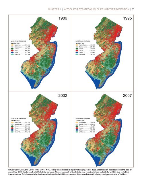
6 | <strong>Landscape</strong> <strong>Project</strong> <strong>Version</strong> <strong>3.1</strong> | CONSERVING IMPERILED WILDLIFE OF NEW JERSEYIn <strong>Version</strong> <strong>3.1</strong> <strong>of</strong> the <strong>Landscape</strong> <strong>Project</strong>,all information has been updated to incorporate► changes to the endangered species list and thenongame wildlife list► a standard, consistent, peer-reviewed method appliedthroughout the state► over 3,500 new species occurrence records in theBiotics database► the most recent Land Use/Land Cover data from 2007The information available in <strong>Version</strong> <strong>3.1</strong> has beenenhanced to► provide a more precise habitat mapping built on speciesspecifichabitat associations► encompass species previously not represented throughoutthe state, including freshwater mussels, marinemammals and marine turtles► include more detailed species information, such as type<strong>of</strong> occurrence and last year <strong>of</strong> occurrence► transparently document the mapping method that isbased on scientific literaturePerhaps most importantly, <strong>Version</strong> <strong>3.1</strong> features easily accessible documentation that includes transparent descriptions<strong>of</strong> the methods used and references to supporting scientific literature. Many <strong>of</strong> these enhancements are a result<strong>of</strong> recommendations that ENSP has received from the public through outreach efforts and information obtainedfrom evaluation forms completed by attendees <strong>of</strong> <strong>Landscape</strong> <strong>Project</strong> training and information sessions conductedover several years. Additional feedback was received during an evaluation <strong>of</strong> the <strong>Landscape</strong> <strong>Project</strong> maps conductedin partnership with the Endangered and Nongame Species Advisory Committee (ENSAC). e evaluation processincluded two stakeholder meetings that generated constructive input from a cross-section <strong>of</strong> <strong>Landscape</strong> <strong>Project</strong> endusersrepresenting federal agencies, county governments, environmental commissions and the consultant community.WHY WE NEED THE LANDSCAPE PROJECT<strong>New</strong> <strong>Jersey</strong>’s landscape is rapidly changing. As the most densely populated state in the nation, pressure to consumeland for development has increased as the population has grown. Yet population growth cannot be isolated asthe only, or even the primary, driving force <strong>of</strong> habitat loss in <strong>New</strong> <strong>Jersey</strong>. Instead, land has been consumed for residentialdevelopment at nearly twice the rate <strong>of</strong> population growth over the past two decades as a result <strong>of</strong> a large-lot,area-intensive land use zoning and development pattern that has encroached on rural landscapes throughout thestate (Hasse & Lathrop 2008, 2010; Hasse et al. 2010). Such a land development pattern also contributes to highertraffic volumes that can lead to increased wildlife mortality or create complete barriers to movement for certainspecies (Seiler 2003; Fahrig & Rytwinski 2009).A detailed landscape analysis performed by Hasse and Lathrop (2010) that utilized the DEP Land Use/Land Cover(LULC) datasets from 1986 to 2007 revealed that a sprawl development pattern continued undeterred and actuallygained momentum over the two decade period. Breaking the study into three time periods (1986-1995, 1995-2002, 2002-2007), the analysis shows a “7% increase in the development rate to 16,061 acres <strong>of</strong> urbanization peryear by 2007, up from the previous rate <strong>of</strong> 15,123 acres per year during the 1995 through 2002 time period,” whichalso experienced an increase up from the rate <strong>of</strong> 14,866 acres per year in the 1986 through 1995 time period (Hasse& Lathrop 2010, p.4). Increasing deforestation, largely due to sprawling residential development, led to urban landsurpassing forest land as the most prominent land type covering the state as <strong>of</strong> 2007 (Hasse & Lathrop 2010). Studiesproject that if the current building pattern continues, all remaining available land will be developed sometime inthe middle <strong>of</strong> this century, making <strong>New</strong> <strong>Jersey</strong> possibly the first state in the nation to reach build-out (Hasse &Lathrop 2001, 2010). e <strong>Landscape</strong> <strong>Project</strong> serves as a tool to help facilitate growth patterns more sensitive to theneeds <strong>of</strong> wildlife and their habitats.
CHAPTER 1 | A TOOL FOR STRATEGIC WILDLIFE HABITAT PROTECTION | 7NJDEP Land Use/Land Cover 1986 - 2007. <strong>New</strong> <strong>Jersey</strong>’s <strong>Landscape</strong> is rapidly changing. Since 1986, urbanization has resulted in the loss <strong>of</strong>more than 5,000 hectares <strong>of</strong> wildlife habitat per year. Moreover, much <strong>of</strong> the habitat that remains is less suitable for wildlife due to habitatfragmentation. This is especially detrimental to imperiled wildlife, as many <strong>of</strong> these species require large, contiguous tracts <strong>of</strong> habitat.