Site Survey Form Generic Format - Coastal Environmental Systems
Site Survey Form Generic Format - Coastal Environmental Systems
Site Survey Form Generic Format - Coastal Environmental Systems
- No tags were found...

Create successful ePaper yourself
Turn your PDF publications into a flip-book with our unique Google optimized e-Paper software.
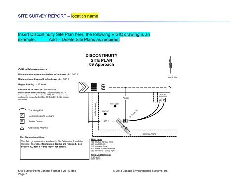
SITE SURVEY REPORT – location nameInsert Discontinuity <strong>Site</strong> Plan here, the following VISIO drawing is anexample. Add – Delete <strong>Site</strong> Plans as required.Critical Measurements:DISCONTINUITYSITE PLAN09 ApproachDistance from runway centerline to 3m tower pin: 500 ftDistance from threshold to 3m tower pin: 900 ftNo ScaleMegger Reading: 1.88 OhmsElevation at 3m tower pin: Not RequiredPower and Comm Trenching: Approximately 403 fttrenching distance from staked FMQ-19 location to powerand comm. located within Bak-12 Bldg 2018.. No knownobstacles.09500 ftBak-12Bldg 2018CPCTrenching PathCommunications DemarcTaxiway AlphaWind SockFMQ-133m Tower PinPPower Demarc900 ftGlideslope AntennaTipping DirectionNon Standard conditions:This field group contains winds only. No Ceilometer foundationrequired. Increased foundation depths are required. Seesection 12, item 1 of this report for details.Misc. Info:403 ft to Bak-12 Bldg 2018.405 ft to FMQ-13.337 ft to Wind Sock831 ft West to Taxiway Alpha250 ft South to Taxiway AlphaGPS Coordinates:N 43 56.16W 90 16.00Taxiway Alpha<strong>Site</strong> <strong>Survey</strong> <strong>Form</strong> <strong>Generic</strong> <strong>Form</strong>at 6-25-13.docPage 7© 2013 <strong>Coastal</strong> <strong>Environmental</strong> <strong>Systems</strong>, Inc.