User's Guide.pdf - MATSim
User's Guide.pdf - MATSim
User's Guide.pdf - MATSim

Create successful ePaper yourself
Turn your PDF publications into a flip-book with our unique Google optimized e-Paper software.
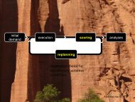
Building new scenariosStarting a new scenario (our term for the application of <strong>MATSim</strong> to a region/area) can appear quite cumbersome at the first glace, as a lotof data preparation may be required. In any case required for a new scenario are:description of the networkdescription of the travel demand (synthetic population)Given these two data items, you can already start building your own scenario. The "Learning <strong>MATSim</strong> in 3 days[http://www.matsim.org/docs/tutorials/learningIn3days]"-Tutorial gives you an introduction on how to build your own scenario.Import from VISUMSee here for javadoc [http://matsim.org/javadoc/org/matsim/visum/package-summary.html], and here for code[http://matsim.org/xref/org/matsim/visum/package-summary.html].ProgrammingIn many cases, using pre-configured software is not possible because there are just too many possibilities of how input could look like.Although matsim is not there yet, these should be api-only use cases, i.e. they should only use the "stable" api. Therefore, the following areunder the api-users section of the documentation:Additional information about network generation is here [http://matsim.org/node/588].additional information about initial demand generation is here [http://matsim.org/node/340].Information concerning specific scenariosThe following sections contains various information for building a scenario that presumably goes beyond what is in the tutorial.Coordinate Systems in <strong>MATSim</strong>For some operations, <strong>MATSim</strong> must know about the coordinate system your data is in. For example, If you want to generate kml-Output forCounts-Validation, <strong>MATSim</strong> has to convert the coordinates in your network to WGS84, the coordinate system used by Google Earth.Specifying the Coordinate System usedYou can specify the coordinate system in the config-file:The value specified for the coordinateSystem parameter can be:The short-name of a coordinate system known to <strong>MATSim</strong>. We define names for coordinate systems we use regularly in our work. Thesenames are currently defined in TransformationFactory[http://matsim.svn.sourceforge.net/viewvc/matsim/matsim/trunk/src/main/java/org/matsim/core/utils/geometry/transformations/Transformationview=markup]. The short-name Atlantis stands for an artificial coordinate system which maps our examples without relation to thereal world somewhere in to the Atlantic ocean.Well-Known-Text (WKT [http://www.geoapi.org/snapshot/javadoc/org/opengis/referencing/doc-files/WKT.html]) description of acoordinate system as they are supported by Geotools. This variant is not very readable, but allows one to experiment also in regionswhere <strong>MATSim</strong> does not provide a short-name for. Examples of WKT can be found in the <strong>MATSim</strong>-class MGC[http://matsim.svn.sourceforge.net/viewvc/matsim/matsim/trunk/src/main/java/org/matsim/core/utils/geometry/geotools/MGC.java?view=markup] (in the transformations map).Notes about Coordinate SystemsAs the distance calculation in WGS84-coordinates (or any spherical coordinates) is rather complex (a simple Pythagoras[http://en.wikipedia.org/wiki/Pythagorean_theorem] is not enough), we advise people to use a Cartesian coordinate systems[http://en.wikipedia.org/wiki/Coordinate_system], preferable where one unit corresponds to one meter. Using such a coordinate system isa pre-requisit if one wants to use the optimized A*Landmarks-Router in <strong>MATSim</strong>.Using <strong>MATSim</strong> for SwitzerlandGeneral remarks