SILVERDALE NEIGHBOURHOOD ONE PLAN - District of Mission
SILVERDALE NEIGHBOURHOOD ONE PLAN - District of Mission
SILVERDALE NEIGHBOURHOOD ONE PLAN - District of Mission

Create successful ePaper yourself
Turn your PDF publications into a flip-book with our unique Google optimized e-Paper software.
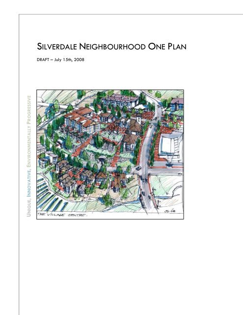
<strong>SILVERDALE</strong> <strong>NEIGHBOURHOOD</strong> <strong>ONE</strong> <strong>PLAN</strong>DRAFT – July 15th, 2008UNIQUE, INNOVATIVE, ENVIRONMENTALLY PROGRESSIVE
This page intentionally left blank
TABLE OF CONTENTSLIST OF MAPS .............................................................. VILIST OF FIGURES .......................................................... VILIST OF TABLES ............................................................ VIACKNOWLEDGEMENTS............................................... VIIPART I – INTRODUCTION ..............................................11.0 BACKGROUND AND INTRODUCTION.................11.1 Location.............................................................................................11.2 Background & History <strong>of</strong> the Planning Process .........................21.3 The Vision and Terms <strong>of</strong> Reference – LAN 48 ..........................31.4 Purpose and Authority <strong>of</strong> the Plan ..............................................41.5 Neighbourhood Planning Advisory Committee .........................51.6 Planning Process..............................................................................61.7 Public Consultation..........................................................................71.8 Technical Studies.............................................................................91.9 Neighbourhood One Planning Area ........................................ 101.10 Future Neighbourhood Planning Boundaries .......................... 112.0 SITE CONTEXT AND DESCRIPTION ....................132.1 Community and Regional Context ............................................ 132.2 Site History.................................................................................... 142.3 Physical Characteristics............................................................... 152.4 Existing Infrastructure.................................................................. 202.5 Population, Housing & Economic Projections........................... 233.0 AREA-WIDE <strong>PLAN</strong>S AND CONCEPTS .................293.1 Conceptual Plan for the Urban Reserve.................................. 29Silverdale Neighbourhood One Plan | DRAFT July 15, 2008 | ii
3.2 Conservation, Parks and Recreation ........................................ 303.3 Area Wide Infrastructure and Servicing Concept................. 303.4 Area Wide Transportation Concept ........................................ 35PART II - PRINCIPLES, GOALS & OBJECTIVES ..............404.0 SUSTAINABILITY PRINCIPLES .............................405.0 GOALS AND OBJECTIVES FOR<strong>NEIGHBOURHOOD</strong> <strong>ONE</strong> ..............................................42PART III - THE <strong>PLAN</strong> FOR <strong>NEIGHBOURHOOD</strong> <strong>ONE</strong> .....526.0 OVERALL CONCEPT ...........................................526.1 Neighbourhood One Concept Plan .......................................... 526.2 Development Precincts ................................................................ 567.0 LAND USE AND DENSITY ...................................587.1 Overview....................................................................................... 587.2 Policies and Plans ........................................................................ 588.0 ENVIRONMENT AND RECREATION ...................638.1 Overview....................................................................................... 638.2 Natural Features Plan................................................................. 638.3 Parks & Plazas ............................................................................. 668.4 Trails............................................................................................... 689.0 HOUSING & RESIDENTIAL DENSITY ...................759.1 Overview....................................................................................... 759.2 Estimated Housing and Population ........................................... 759.3 Policies ........................................................................................... 759.4 Housing Types .............................................................................. 7910.0 ECONOMIC DEVELOPMENT & JOBS ...............9010.1 Overview....................................................................................... 90Silverdale Neighbourhood One Plan | DRAFT July 15, 2008 | iii
10.2 Policies ........................................................................................... 9110.3 Economic Activity Outside <strong>of</strong> Neighbourhood One............... 9311.0 TRANSPORTATION.........................................9511.1 Overview....................................................................................... 9511.2 Policies and Plans ........................................................................ 9512.0 BUILDINGS AND INFRASTRUCTURE .............10412.1 Overview.....................................................................................10412.2 Policies .........................................................................................10413.0 COMMUNITY FACILITIES & SOCIAL ISSUES ..10913.1 Overview.....................................................................................10913.2 Policies .........................................................................................11114.0 HISTORY, CULTURE & IDENTITY....................11514.1 Overview.....................................................................................11514.2 Policies .........................................................................................115PART IV: IMPLEMENTATION ......................................11715.0 IMPLEMENTATION POLICIES.........................11715.1 Introduction..................................................................................11715.2 Effect............................................................................................11715.3 Advisory.......................................................................................11715.4 Regulatory Instruments..............................................................11715.5 External Agencies ......................................................................11815.6 Chance Find Procedure.............................................................11815.7 Other Initiatives..........................................................................11915.8 Consequential Amendments .....................................................11915.9 Secondary Planning Area ........................................................11916.0 MISCELLANEOUS CONSIDERATIONS............12216.2 General Site Planning and Development..............................12216.3 Circulation and Access ..............................................................123Silverdale Neighbourhood One Plan | DRAFT July 15, 2008 | iv
PART V: DEVELOPMENT PERMIT AREA GUIDELINES.12617.0 <strong>SILVERDALE</strong> <strong>NEIGHBOURHOOD</strong> <strong>ONE</strong>DEVELOPMENT PERMIT AREA ...................................12617.1 Introduction..................................................................................12617.2 Designation as Development Permit Area ............................12717.3 General Development Guidelines..........................................12817.4 Building Form & Character Guidelines..................................13117.5 Landscape Character Guidelines ...........................................13517.6 Recommended Colour Palette.................................................136PART VI: APPENDICES ...............................................142APPENDIX A: LIST OF HISTORICAL NAMES...............142APPENDIX B: TECHNICAL STUDIES REFERENCE LIST..148Silverdale Neighbourhood One Plan | DRAFT July 15, 2008 | v
LIST OF MAPSMap 1: Site Location and Context............................................................1Map 2: Silverdale Urban Reserve - Regional Context.........................2Map 3: Community Map.............................................................................8Map 4: Neighbourhood One Study Areas........................................... 12Map 5: Fraser Valley Regional <strong>District</strong>................................................. 13Map 6: Aquatic Habitat Mapping......................................................... 17Map 7: Geotechnical and Environmental Opportunities andConstraints (GEOC)................................................................................... 19Map 8: Existing Road Network in Southwest <strong>Mission</strong> ......................... 20Map 9: Study Area Catchments ............................................................. 22Map 10: Bulk Water Servicing............................................................... 32Map 11: Off-site Sanitary Servicing Corridors................................... 33Map 12: Sewer Network Layout............................................................ 34Map 13: Conceptual Roadway Network Classification..................... 35Map 14: Area-wide Trail Concept ........................................................ 39Map 15: Land Use Plan ........................................................................... 59Map 16: Natural Features Plan.............................................................. 71Map 17: Parks and Trails Plan............................................................... 72Map 18: Housing Types by Precinct...................................................... 78LIST OF FIGURESFigure 1: Projection Population Change by Age Group 2006 -2026...................................................................................................................... 23Figure 2: Southwest <strong>Mission</strong> Concept Plan............................................ 29Figure 3: Neighbourhood One Concept Plan in Context................... 54Figure 4: Detailed Concept Plan for Neighbourhood One ............... 55Figure 5: Development Precincts............................................................. 56Figure 6: Preliminary Views from the South. Better quality imageswill be provided prior to public hearing. ............................................. 57Figure 7: Conceptual Roadway Network Classifications................... 96Figure 8: Arterial – Parkway Village.................................................... 97Figure 9: Arterial – Parkway South....................................................... 97Figure 10: Collector.................................................................................. 98Figure 11: Rural Local Residential.......................................................... 98Figure 12: Public Lane.............................................................................. 98Figure 13: Integrated Stormwater Management..............................107LIST OF TABLESTable 1: Unit Demand by Type.............................................................. 24Table 2: Silverdale Development Potential ......................................... 26Table 3: Summary <strong>of</strong> Estimated Population, Dwelling Units, andEconomic Potential..................................................................................... 28Silverdale Neighbourhood One Plan | DRAFT July 15, 2008 | vi
Table 4: Unit Demand by Type.............................................................. 76Table 5: Dwelling Unit Counts by Precinct Based on Concept Plan. 76Table 6: Conceptual Alternate Hillside Street Standards ................. 99Table 7: Studies - Secondary Study Area..........................................120Table 8: Additional Studies - Secondary Study Area......................121ACKNOWLEDGEMENTSThis plan was prepared with the participation <strong>of</strong> the NeighbourhoodPlanning Advisory Committee (NPAC) who generously gave <strong>of</strong> theirtime. Rex Blane Marilyn Boswyk Robert Demers Margaret Eggen Kosh Gill (retired early) Bill Hamilton Dave Keenan Kim Kokoszka John Laing (retired early) Joanne Long Ivy McLeod Anne Norder (retired early) Kevin O’Beirne Danny Plecas Mike Scudder Jim Taylor Ron Taylor Dirk WeymannSilverdale Neighbourhood One Plan | DRAFT July 15, 2008 | vii
Hayward StGaglardi StFarrington StManzer StWolfe StBarrett StOyama StHurd StPART I – INTRODUCTION1.0 BACKGROUND AND INTRODUCTION1.1 LocationThis document describes a plan for the area known as SilverdaleNeighbourhood One, an approximately 440-acre area located inSouthwest <strong>Mission</strong> and shown in Map 1. Neighbourhood One is part<strong>of</strong> a the larger Silverdale Urban Reserve which occupiesapproximately 3400 acres in Southwest <strong>Mission</strong> north <strong>of</strong> Highway 7(Map 2). The area is located on Silverhill, a distinct geographicalfeature within the Fraser Valley. To the west is Silvermere Lake andto the east the area is physically separated from the rest <strong>of</strong> <strong>Mission</strong>by Silverdale Creek and its large steep-sided ravine.Map 1: Site Location and ContextSilvermere LakeLegendWoodward StUrban Reserve BoundaryNeighbourhood One BoundarySilverhill AveForsell AveStephen StSlaterStKeystone AveLaslo AveDewdeny Trunk RdCedar RidgeGolf CourseSilver CresAnderson AveFoulds StRodman AveClay StRodman AveDonatelli AveOlson AveFraser RiverMcLean StFoote StSilverdaleCommunityNeighbourhood OneGunn AveGalliford StViewcrest AveBench AveGrove AveWren StCherry AveAbbotsfordLougheed HighwayCP RailSilverdale AveHighway 7L<strong>of</strong>tus StNelson StAves Terr<strong>Mission</strong> Golfand Country ClubIsrael AveKenney Ave<strong>Mission</strong> SportsParkSilverdale CreekWren StBest Ave14th AveSilverdale Neighbourhood One Plan | DRAFT July 15, 2008 | 1
1.2 Background & History <strong>of</strong> the Planning ProcessThe Silverdale area in Southwest <strong>Mission</strong> has been the subject <strong>of</strong>intense planning deliberations for many years. The area has beenidentified as an Urban Reserve (an area reserved for future urbandevelopment) since the 1960’s and is identified in the Fraser ValleyRegional <strong>District</strong>’s (FVRD) Regional Growth Strategy (RGS) as anarea <strong>of</strong> future settlement.In 2005, following extensive planning work by two majorlandowners (Genstar & Madison) and a lengthy public hearing,Council amended the (OCP) land use designation <strong>of</strong> part <strong>of</strong> theSilverdale Area from “Urban Reserve” to “Urban Residential”. TheUrban Residential area (1,435 acres) is known as the SilverdaleUrban Residential Area (SURA). This decision contemplateddevelopment <strong>of</strong> this area up to “urban” densities predicated on theavailability <strong>of</strong> municipal services (water, sewers).Map 2: Silverdale Urban Reserve - Regional ContextMapleRidge<strong>District</strong> Of<strong>Mission</strong>Fraser Valley<strong>District</strong> FSilverdale Urban Reserve<strong>Mission</strong>UrbanAreaHatzic Urban AreaLangleyAbbotsfordMatsquiMain 2Silverdale Neighbourhood One Plan | DRAFT July 15, 2008 | 2
1.3 The Vision and Terms <strong>of</strong> Reference – LAN 48Following the decision to designate the lands as “urban residential”in the OCP, Council adopted a detailed terms <strong>of</strong> reference, knownas Silverdale Urban Residential Neighbourhood Plans Terms <strong>of</strong>Reference Policy - LAN 48. This policy described in some detail howneighbourhood plans within this area should be developed and theinformation/studies required to support the planning. The followingis an extract from the document:Extract from LAN 48The Official Community Plan identifies broad objectives andpolicies to guide environmental management and growth anddevelopment within the designated Silverdale Urban ResidentialArea <strong>of</strong> the <strong>District</strong> <strong>of</strong> <strong>Mission</strong>. These policy directions areintended to be reflected in more detailed Neighbourhood Plans(NP) that will apply to each neighbourhood within the SilverdaleUrban Residential Area.This Terms <strong>of</strong> Reference is intended to serve as a Council policyfor the preparation <strong>of</strong> Neighbourhood Plans, their contents andconsultation requirements. Each NP will identify a policyframework for environmental management, land use,transportation, and requirements for servicing and financing, andprovide additional studies and reports that are required as part <strong>of</strong>the NP process.The Neighbourhood Plan process represents a significantopportunity to shape the future character <strong>of</strong> <strong>Mission</strong>. There is aneed to formulate Neighbourhood Plans in accordance with social,economic and environmental sustainable development principles soas to provide <strong>Mission</strong> with a unique, innovative, progressive andenvironmentally responsive land use pattern within the designatedSilverdale Urban Residential Area.This Terms <strong>of</strong> Reference Policy therefore requires NeighbourhoodPlans to follow the sustainable principles approach <strong>of</strong> integratingsocial, economic and environmental values, and ensuring <strong>Mission</strong>can grow and change in a manner that does not compromise theoptions <strong>of</strong> either existing or future residents. The overall intent <strong>of</strong>the Neighbourhood Plan process is to establish a planningframework that will result in the Silverdale Urban Residentialdevelopment representing the most advanced, innovative andlivable planned community within the Lower Mainland area.<strong>Mission</strong> is to evolve into a better community as a result <strong>of</strong> thisdevelopment, rather than losing its identity and becomingindistinguishable from so many other urban communities.Silverdale Neighbourhood One Plan | DRAFT July 15, 2008 | 3
1.4 Purpose and Authority <strong>of</strong> the PlanAs outlined in LAN 48, this plan for Neighbourhood One isformulated “in accordance with social, economic and environmentalsustainable development principles so as to provide <strong>Mission</strong> with aunique, innovative, progressive and environmentally responsive landuse pattern.”SustainabilitySustainability is about reducing our environmental impact andenhancing social cohesiveness in a way that makes economic sense.Although global in its focus, sustainability really “touches theground” at the neighbourhood and site level, and is thereforerooted in how communities are planned, developed and operated.Highly liveable, walkable, energy-efficient, compact communitiesthat reduce per-capita ecological footprint and contribute to bothhuman and ecological health are at the forefront <strong>of</strong> sustainability.The Silverdale Neighbourhood One Plan is part <strong>of</strong> the <strong>District</strong> <strong>of</strong><strong>Mission</strong>’s Official Community Plan (OCP) and, as such, has the samelegal authority and is subject to the same requirements as an OCPas specified in the BC Local Government Act (LGA). Consequently, itmust dovetail with this municipal instrument which has broader andmore general scope as well as Provincial instruments such as the LandTitle Act. Some matters developed as part <strong>of</strong> this NeighbourhoodPlan are <strong>of</strong> broader applicability. These more properly, areadopted in the <strong>District</strong>-wide OCP.The neighbourhood plan consists <strong>of</strong>: 1) plans: land use, green spacetransportation and infrastructure plans; 2) policies regardingdevelopment, infrastructure, environmental conservation, social issues,and community facilities; 3) design guidelines regarding buildingform and character and landscaping.; 4) Implementation steps thatdescribe the steps the <strong>District</strong> will take to put the plan into practice.This plan is intended to guide applicants making rezoning,subdivision and development applications and also to provide aframework for decision-making by <strong>District</strong> Council and <strong>District</strong> staffregarding whether or not to recommend/approve applications andwhat conditions to attach to approvals. 1 As required by the LocalGovernment Act, decisions by the <strong>District</strong> must be consistent with thisplan. If changes to the plan are needed or desired, it must beamended in accordance with the LGA and <strong>District</strong> Policy.1 Applicant: A landowner or their agent who request a change in landuse (zoning), reconfiguration <strong>of</strong> land parcels (subdivision) or authorityto build in compliance with design guidelines (development permit).Silverdale Neighbourhood One Plan | DRAFT July 15, 2008 | 4
1.5 Neighbourhood Planning Advisory CommitteeThis plan was developed with the participation <strong>of</strong> theNeighbourhood Planning Advisory Committee (NPAC), a volunteergroup <strong>of</strong> <strong>District</strong> <strong>of</strong> <strong>Mission</strong> residents who met with staff andconsultants throughout the planning process.The committee’s purpose was to “agree as a committee on anintegrated neighbourhood plan for Neighbourhood One within theSilverdale urban residential area to be recommended for Council’sconsideration.”Specific NPAC responsibilities included: Developing guiding principles in support <strong>of</strong> the plan; Promoting public input into the planning process; Examining various design options; and Incorporating a broad range <strong>of</strong> community interests andperspectives in the plan.Silverdale Neighbourhood One Plan | DRAFT July 15, 2008 | 5
1.6 Planning ProcessThe Silverdale Neighbourhood One plan was developed throughfive phases <strong>of</strong> planning, each building upon the previous phase <strong>of</strong>work: Phase 1 generated a set <strong>of</strong> planning principles that reflectthe core values <strong>of</strong> the plan (see section 4). Phase 2 produced a statement <strong>of</strong> goals and objectives thataddress community issues in addition to setting clear directionfor design. Following articulation <strong>of</strong> goals and objectives, apreliminary development program (i.e. # <strong>of</strong> housing types,commercial space, parks, etc.) was developed to focusdesign efforts in Phase 3. This work was combined withpreliminary ‘opportunities and constraints’ studies thatdescribed physical attributes, environmental conditions,market demand, population projections and access andinfrastructure. Phase 3 employed a series <strong>of</strong> design workshops to createdesign options for the neighbourhood plan. The final conceptplan was developed based on technical analysis as well asthe feedback from the Neighbourhood Planning AdvisoryCommittee, <strong>District</strong> Council, staff, and various stakeholders. Phase 4 involved the drafting <strong>of</strong> the neighbourhooddocument. Technical studies were finalized and policies andguidelines were developed to ensure the plan is executed asenvisioned. Phase 5 is the final consideration <strong>of</strong> the plan by the public ata public hearing and a decision by Council. If approved, thedevelopment applicant and other landowners will be able toproceed through the next stages <strong>of</strong> the development process(i.e. rezoning, subdivision, etc.).Silverdale Neighbourhood One Plan | DRAFT July 15, 2008 | 6
1.7 Public ConsultationEngaging the public was a central element <strong>of</strong> the SilverdaleNeighbourhood One Planning Process. Details <strong>of</strong> the planningprocess and consultation activities were circulated widely through thedistrict to reach the highest number <strong>of</strong> citizens, using many differentcommunication channels (mail-drop to every household in <strong>Mission</strong>,large colourful ads in local papers, stories in the <strong>District</strong> section <strong>of</strong>the paper, emails through various existing networks, posters onpostal boxes and community bulletin boards, letters to localresidents, project website with FAQs, etc.).The consultation “brand” and imagery was based on the project’s 5planning phases, requesting input from the general public andSilverdale residents in every stage on topics such as: Planning principles for the first neighbourhood Community visions for the neighbourhood History and stories <strong>of</strong> the Silverdale area Key findings from the technical studies Assessments <strong>of</strong> plan options and the final planEvents included a “Public Ideas Fair” and open houses that weredesigned to share information, explain the planning process, andgather attendee’s ideas on the future <strong>of</strong> the community. Communitymapping resulted in showing, among other items, the location <strong>of</strong>historic events and sites that will be acknowledged with plaques,street and park names as part <strong>of</strong> the subdivision process. Duringphases 1 and 2, public input was gathered through consultationmethods such as sketch design, community mapping, focusedfeedback forms, email, phone calls, and face-to-face conversationswith the project team. The project planner met with communitygroups to provide and overview <strong>of</strong> the process and to obtain input.An open house following the Phase 3 Options Charrette (designworkshop), allowed the public to review and comment on twodifferent planning and design options for Neighbourhood One.Public input was consolidated and presented to NeighbourhoodPlanning Advisory Committee, the design team, <strong>District</strong> staff, andCouncil at every phase to help shape all elements <strong>of</strong> theneighbourhood plan.Silverdale Neighbourhood One Plan | DRAFT July 15, 2008 | 7
1.8 Technical StudiesAs required by LAN 48, studies on all aspects <strong>of</strong> the site,infrastructure, market and surrounding area were commissioned.Some <strong>of</strong> these studies examined area-wide concerns while othersfocused specifically on Neighbourhood One. Initially, these studiesidentified opportunities and constraints for development and thisinformation was used to develop the design brief and guideformulation <strong>of</strong> the concept plans at the design charrettes. Thesestudies provide critical background information and, therefore, thisplan should be read in conjunction with these studies. Technicalstudies are available on the <strong>District</strong> <strong>of</strong> <strong>Mission</strong> website atwww.mission.ca/sura. Full study references are provided inAppendix B.List <strong>of</strong> Technical Studies Stream Surveys & Mapping Fisheries Assessment Fisheries Setback Zones Tree Management Climate Studies Water Quality Vegetation & Habitat Wildlife Special Species Status Wildlife Corridors Special Status Species Plan Environmental Protection Plan Environmental Monitoring Plan Stewardship Geotechnical Hydro-geological PreliminaryReview & Impact Assessment Hydro-geological Assessment Landslide Risk Area Wide Transportation Transportation DemandManagement (TDM) Study Neighbourhood Transportation Bulk Water Supply Trunk Sewer System Integrated StormwaterManagement Plan Slope Analysis Archaeological Park & ESA Acquisition Energy Technology Stream & Rainfall Monitoring Alternate Standards Community League Feasibility Projected Retail Demand Future Employment Needs Leisure & Community Facilities Finance/Cost Recovery Strategy Landscape Design Strategy Housing Market Study Geotechnical & EnvironmentalOpportunities & Constraints(GEOC) ReportSilverdale Neighbourhood One Plan | DRAFT July 15, 2008 | 9
1.9 Neighbourhood One Planning AreaAn initial task <strong>of</strong> the Neighbourhood Plan Advisory Committee wasto define a study area boundary. They were encouraged byCouncil’s policy to consider natural features such as watersheds. Astudy area boundary incorporating the Jamieson and Chester Creekwatersheds as well as numerous smaller water courses on the southslope running down to Silverdale Road with a westerly boundarydefined by the existing Silverdale Suburban Area was chosen. Atthat time it was resolved that:“The area shown as Primary Study Area (1) will be planned indetail as Silverdale Neighbourhood One and included in thedesign charrette process. It is anticipated that a plan for thisarea will be brought forward as a proposed OCP amendmentin Summer 2008.” (NPAC resolution, September 27, 2007meeting minutes, p.2)At the same time it was resolved that:“The area shown as Secondary Study Area (2) will be plannedat the same time as Area 1 and will also be included in thedesign charrette process. However, it is recognized that someadditional detailed studies will be required to be completedbefore the detailed planning <strong>of</strong> the area can be finalized.Therefore, it is anticipated that a proposed OCP amendmentwill come forward at a later date after these studies have beencompleted.” (NPAC resolution, September 27, 2007 meetingminutes, p.2)In spite <strong>of</strong> this resolution, this plan only applies to the Primary StudyArea, which is Silverdale Neighbourhood One. This plan and itsconsequential OCP amending bylaw do not apply to the SecondaryStudy Area (see Map 4).It is acknowledged that roads and infrastructure corridors will haveto cross the secondary area to provide access to NeighbourhoodOne.Neighbourhood One was divided into two study areas (Map 4)because <strong>of</strong> a difference in the availability <strong>of</strong> information on which tobase planning and design work. Neighbourhood One is the subject<strong>of</strong> detailed environmental studies regarding, wildlife and detailedgeotechnical information.The secondary study area has not had the same level <strong>of</strong> detailedenvironmental and geotechnical study. Therefore, the secondarystudy area was not included in the detailed planning exercise.Landowners within this area will be required to complete theseSilverdale Neighbourhood One Plan | DRAFT July 15, 2008 | 10
detailed studies prior to any OCP amendment or re-zoning inaccordance with LAN 48 (see section 15.0 Implementation).1.10Future Neighbourhood Planning BoundariesThe boundaries for future neighbourhood planning areas should beestablished using similar criteria as those used for NeighbourhoodOne, as well as considerations for phasing <strong>of</strong> infrastructure servicing.The boundaries <strong>of</strong> these neighbourhoods will be established as part<strong>of</strong> future neighbourhood planning processes.Silverdale Neighbourhood One Plan | DRAFT July 15, 2008 | 11
Olson AveGalliAves TerrMcFall TerrNelson StL<strong>of</strong>tus StGunn AveSilverdale AveLougheed HighwayManzer Strve Boundaryood One BoundaryStudy Area BoundaryNeighbourhood One(Primary Study Area)Secondary Study Area
2.0 SITE CONTEXT AND DESCRIPTION2.1 Community and Regional ContextThe <strong>District</strong> <strong>of</strong> <strong>Mission</strong> is located in the Fraser Valley Regional<strong>District</strong>, which also includes the Cities <strong>of</strong> Abbotsford and Chilliwack,the <strong>District</strong>s <strong>of</strong> Kent and Hope, the Village <strong>of</strong> Harrison Hot Springs,and eight electoral areas. Historically, the FVRD has beencharacterised by rural life and farming; however, increasingpopulations throughout the Lower Mainland have resulted in rapidlygrowing urban centres. FVRD populations are forecasted to doublein the next 20 – 30 years. The FVRD aims to find a balance betweenprotecting green space, preserving agriculture land and heritage,and sustainable urban growth.<strong>Mission</strong> is situated on the slopes overlooking the Fraser River,bordered by the Coast Mountains to the north. The community isknown for its rich history, natural beauty, and rural living inproximity to Vancouver.The Urban Reserve contains a number <strong>of</strong> existing estate residentiallots as well as the existing Silverdale community which is designatedas suburban residential in the OCP. There is an existing activeschool, the Silverdale Community Hall, and the smaller Silverhill Hall.Three gas stations on Highway 7 (Lougheed Highway) provide theonly existing commercial outlets.Map 5: Fraser Valley Regional <strong>District</strong>Great views are common from the areaFVRDRegional Growth Strategy Goals1. Increase Transportation Choiceand Efficiency.2. Support and Enhance theAgricultural Sector.3. Manage Urban LandResponsibly.4. Develop a Network <strong>of</strong>Sustainable Communities.5. Protect the Natural Environmentand Promote EnvironmentalStewardship.6. Protect and Manage Rural andRecreational Lands.7. Achieve Sustainable EconomicGrowth.8. Manage Water, EnergyResources and WasteResponsibly.Source: Choices for our Future, FVRDRegional Growth Strategy, 2004Source: Choices for our Future, FVRD Regional Growth Strategy, 2004Silverdale Neighbourhood One Plan | DRAFT July 15, 2008 | 13
2.2 Site HistoryHistorically the Silverdale area was farmed and logged by anumber <strong>of</strong> pioneer families. An aerial photograph from 1938 showsthe area as recently logged, with mature trees remaining only withinthe steep ravines. Many <strong>of</strong> these pioneer families are stillrepresented in the community today and their names are reflected inlocal place and street names. A list <strong>of</strong> family names is provided inthe appendix for consideration in naming elements <strong>of</strong> this plan.Silverdale Hall underConstruction c.1951Silverhill SchoolAerial Photo 1938Silverhill Community HallSilverdale Landholders c.1895Silverdale Community HallSilverdale Neighbourhood One Plan | DRAFT July 15, 2008 | 14
2.3 Physical Characteristics2.3.1 TopographySilverhill (365 metres at its peak), is steeply sloped and there is littleflat land suitable for industrial or institutional uses. The area hasvaried slopes ranging from almost flat to slopes <strong>of</strong> more than 70%.The transition between steep slopes and flatter areas is marked insome cases by ridgelines (sometimes treed) that form distincttopographical features.Some <strong>of</strong> the sites are too steep for development while othermoderately steep slopes can only be developed with due care andattention to geotechnical considerations. The amount <strong>of</strong> relativelyflat land preferred for playing fields and industrial uses is limited,especially in Neighbourhood One.2.3.2 GeologyThe area is underlain by tertiary bedrock including basalts. Theupper slopes <strong>of</strong> Silverhill are overlain by one to five metres <strong>of</strong>glacial drift. The lower slopes, below approximately 200melevation, are composed <strong>of</strong> Sumas Drift. Below 50m elevationchannel fills and floodplain deposits occur.Source: Golder Associates. Hydrogeological Assessment. May 2008.Silverdale Neighbourhood One Plan | DRAFT July 15, 2008 | 15
2.3.3 Climate<strong>Mission</strong>’s climate is warm in the summer and generally mild and wetin the winter. Mean annual precipitation is approximately 1800mm.2.3.4 EnvironmentAquatic HabitatThe numerous watercourses within the Urban Reserve boundary, andtheir aquatic features, have been surveyed and mapped in severalphases since 1999. Portions <strong>of</strong> the following streams have beenshown to contain fish (see Map 6): Silverdale Creek Chester Creek Lower and Middle Jamieson Creek Lower Sylvain Creek Lower Smith Brook Lower Rae Creek Tributary AIn addition, several wetlands have been identified, some <strong>of</strong> whichare connected to streams while others are isolated.Terrestrial HabitatMuch <strong>of</strong> the area is treed with second-growth or third-growthdeciduous and mixed forest. Open pasture areas remain fromprevious active grazing operations, but little <strong>of</strong> the land has beenactively farmed for many years. Smaller stands <strong>of</strong> mature trees existthroughout the site including within ravines and on ridgelines.Several studies <strong>of</strong> wildlife and habitat in the area have beencompleted. One at-risk plant species, provincially blue-listed waterpepper,was found on the site. Larger mammals that inhabit or usethe area at times include black-tailed deer, black bears, bobcat,cougars and coyotes among others. Numerous species <strong>of</strong> birds havebeen identified in the area, including songbirds and for which thereis a diversity <strong>of</strong> habitat types and landscape forms. Amphibians areresident in the area, including red-legged frogs, tree frogs (whichare common), and the invasive, non-native bull frog and green frog.The red-legged frog is provincially red-listed and federally listedand has been documented as breeding on the site. Oregonforestsnails are present in moist deciduous forest, in association withbigleaf maple and stinging nettle; this species is provincially redlistedand federally listed. Further details can be found in theenvironmental reports that accompany this plan. 22 SLR Consulting and Golder Associates. June 2008. Final Report, 2007 EnvironmentalStudies, Vegetation and Wildlife Component, Neighbourhood One Study Area, <strong>Mission</strong>BC.Silverdale Neighbourhood One Plan | DRAFT July 15, 2008 | 16
or DitchsdaryeStream information is sourced form Technical Study # 9.01; Stream surveys and mapping by SLR consulting (Canada) Ltd.; This information is
2.3.5 Geotechnical and Environmental Opportunities andConstraints SummaryThe Geotechnical and Environmental Opportunities and ConstraintsSummary Map (See Map 7) and accompanying report is a summary<strong>of</strong> material from the geotechnical, upland habitat and riparianhabitat studies. It combines information about wildlife, includingspecies at risk, watercourses with setbacks to both municipal andfederal standards, and geotechnically sensitive areas such asravines, steep slopes and hazardous areas. This map was developedthrough discussions with <strong>District</strong> Staff, the peer reviewers, and theenvironmental consultant team, using the data from technical studies9.01 – 9.10, 11.03, and 18.0. The map that resulted from thosediscussions was a very important starting point for land use planningand design work because it provided science-based context todefine those areas that should be conserved, those areas that aremore sensitive to development and those areas considered moresuitable for development. This ecological approach to land useplanning, which is a fundamental shift from incremental developmentapplications, is the basis <strong>of</strong> ecological sustainability for thisneighbourhood plan. 33 <strong>District</strong> <strong>of</strong> <strong>Mission</strong>. Geotechnical and Environmental Opportunities and ConstraintsSummary Map. April 2008.Silverdale Neighbourhood One Plan | DRAFT July 15, 2008 | 18
Hayward StFarrington StWolfe StManzer StBarrett StWren StHurd StCedar StGrand St2.4 Existing Infrastructure2.4.1 Transportation & Travel PatternsThe area has a low road density at present. Olson Avenue, GunnAvenue, L<strong>of</strong>tus Street, Gagliardi, and Silverdale Avenue, WolfeStreet and Silverhill Avenue are the roads that currently provideaccess to Neighbourhood One.Trips to the <strong>District</strong>’s Municipal Hall <strong>of</strong>fices and other parts <strong>of</strong> <strong>Mission</strong>would more than likely occur by car, since transit service from mostresidential areas <strong>of</strong> the community is generally considered to bepoor for those ‘choice’ trip makers. The distribution <strong>of</strong> all afternoonpeak hour trips to and from the <strong>District</strong> <strong>of</strong> <strong>Mission</strong> indicates thatsignificant proportions <strong>of</strong> the afternoon peak hour trips (65%)remain within <strong>Mission</strong> and approximately 35% are generatedto/from external areas. Of the external trips, 15% are generatedto and from the west and 20% are generated to areas in the south(Abbotsford), southwest (Langley, Surrey) and southeast (Chilliwack)and to the east. 4Map 8: Existing Road Network in Southwest <strong>Mission</strong>Malquist AveKeystone AveDewdeny Trunk RdSilverhill AveStephen StSlater StLaslo AveWoodward StMcLean StGaglardi StGunn AveSilverdale AveLougheed HighwayL<strong>of</strong>tus StFoulds StOlson AveNels on StMcFall TerrClay StViewcrest AveGrove AveBench AveIsrael AveKenney AveWrenCaribou StStBest Ave14th AveCherry AveLegend7th AveProvincial CorridorMunicipal CorridorCollector StreetCollector(Corridor TBD)4 Urban Systems Ltd. Area-wide Transportation Study. April 2008.Silverdale Neighbourhood One Plan | DRAFT July 15, 2008 | 20
2.4.2 Existing Sanitary SewersThe <strong>District</strong> <strong>of</strong> <strong>Mission</strong> sanitary sewer system currently does notextend to the Urban Reserve. Existing developed lots are servicedby individual septic tanks and absorption fields. 52.4.3 Existing Water SupplyExisting dwellings and businesses within the Urban Reserve arecurrently serviced by individual private wells. The existing municipalsystem has two water sources, the Cannell Lake system and theNorrish Creek system, both <strong>of</strong> which are jointly owned by the City <strong>of</strong>Abbotsford and <strong>District</strong> <strong>of</strong> <strong>Mission</strong>, and operated by Abbotsford.The Cannell Lake system is currently running at capacity. 62.4.4 Existing Drainage SystemThe Neighbourhood One portion <strong>of</strong> the hillside consists <strong>of</strong> multiplecatchments <strong>of</strong> moderate to steep slopes draining towards the FraserRiver (Map 9). The northern portion <strong>of</strong> Neighbourhood One,comprising Jamieson Creek catchment and some smaller tributaries,flows west through the community <strong>of</strong> Silverdale, before entering theFraser River.The southern portion <strong>of</strong> Neighbourhood One, with multiple smallhillside catchments, drains south through agricultural lands to theChester Pump Station before discharging to the Fraser River. 75 Urban Systems Ltd., Trunk Sanitary Sewer System, April 20086 Urban Systems Ltd., Bulk Water Supply. May, 20087 Urban Systems Ltd., Integrated Stormwater Management Plan: Stage 1 –Inventory. April 2008.Silverdale Neighbourhood One Plan | DRAFT July 15, 2008 | 21
2.5 Population, Housing & Economic Projections2.5.1 Population and Demographic TrendsBetween 2006 and 2026, the population <strong>of</strong> <strong>Mission</strong> could almostdouble from 34,495 people to 65,625 people. Within thisprojection there are dramatic differences between the growth rates<strong>of</strong> different age groups. Over the next two decades the number <strong>of</strong>people aged 45 to 54 is projected to increase by 59% (3,292people), whereas the 65 to 74 age group could add slightly morepeople (3,511), which would equate to 178% growth.Each <strong>of</strong> the three age groups over the age <strong>of</strong> 55 are projected togrow faster than the community average <strong>of</strong> 90% over this 20 yeartime frame, as is the 25 to 34-year-old age group (96%). The under25 and 35 to 54 age groups are projected to grow relatively lessthan the <strong>District</strong> as a whole.In terms <strong>of</strong> absolute numbers, the under-25 age group is projectedto grow by over 8,600 people between 2006 and 2026,representing 28% <strong>of</strong> the total population growth over that period.With an increase <strong>of</strong> almost 5,000 people, the 55 to 64 age groupwill see an average <strong>of</strong> 250 people per year added to this agegroup in <strong>Mission</strong> for the next two decades. 8Figure 1: Projection Population Change by Age Group 2006 -20268 Jorden Cook Associates and Colliers International, Housing Demand Study. April2008.Silverdale Neighbourhood One Plan | DRAFT July 15, 2008 | 23
2.5.2 Housing Demand<strong>District</strong> <strong>of</strong> <strong>Mission</strong>: It is estimated that <strong>Mission</strong> will see new demandfor over 6,600 new dwelling units between 2006 and 2016 toaccommodate its growing and changing population. This representsa 54% increase in total dwelling unit demand in the <strong>District</strong>, resultingfrom a 49% increase in population growth. Dwelling unit demandwill increase faster than the population because as people age theyhave, on average, fewer people in the household. <strong>Mission</strong> has anaging population. Between 2001 and 2006 the number <strong>of</strong> peopleaged 65 plus in the <strong>District</strong> increased from 3,290 to 3,700, and themedian age <strong>of</strong> the population increased from 36.3 to 37.5.Approximately 67% (4,439 units) <strong>of</strong> demand over the next decadeis projected to be for households in single-family homes; 19% <strong>of</strong>demand (1283 units) will be for apartments; and approximately14% (891 units) will be for other ground oriented units.From 2016 to 2026 there is projected to be demand for additional5,785 units in the <strong>District</strong>. Almost 64% <strong>of</strong> this demand will be forhouseholds in single-family homes; 21% will be for apartments; and15% <strong>of</strong> the demand will be for other ground oriented units.Approximately 10% <strong>of</strong> the total single family units would beexpected to be ‘apartment, duplex’ suites, based on 2001 and2006 census data.Looking at dwelling unit demand in <strong>Mission</strong> by tenure type, based onFraser Valley rates, home ownership will continue to be a morepreferred tenure option. In the decade from 2006 to 2016 therewill be demand for almost 5,000 new homes for individuals to ownand live in. This represents 75% <strong>of</strong> the new dwelling demand. Overthe same period there will be additional demand for 1,628 newhomes for renters, representing 25% <strong>of</strong> new units. 9Table 1: Unit Demand by Type<strong>District</strong> <strong>of</strong> <strong>Mission</strong>,Private Dwelling Units Demand by Type 2006-2016 % Split 2016-2026 % SplitSingle Family 4,439 67% 3,691 64%Other Ground-Oriented (i.e. townhouses) 891 14% 857 15%Apartment 1,283 19% 1,237 21%Total 6,613 100% 5,785 100%9 Jorden Cook Associates and Colliers International, Housing Demand Study. April2008.Silverdale Neighbourhood One Plan | DRAFT July 15, 2008 | 24
Silverdale: <strong>District</strong> will need almost 12,400 dwelling units over thenext two decades in order to accommodate its projected populationgrowth. Based on development trends, and land capacity in otherparts <strong>of</strong> the <strong>District</strong>, outside <strong>of</strong> Silverdale, <strong>Mission</strong> can accommodateapproximately 6,371 dwelling units, comprised <strong>of</strong> 3,141 singledetached homes, 1,592 townhouses, and 1,638 apartments. Thissection shows the dwelling unit split between single-family andmultifamily units that Silverdale will have the potential toaccommodate based on the projections <strong>of</strong> demand by unit type andthe ability <strong>of</strong> other neighbourhoods to absorb that demand.Single-DetachedThe development potential in the rest <strong>of</strong> <strong>Mission</strong> over the2006 to 2026 period is for 3,201 single detached homes.The projected demand in the municipality over that period isexpected to be for 8,131 units, leaving a residual demandfor 4,930 units that could be accommodated in Silverdale.TownhousesSupply analysis showed that 1,592 townhouses could beaccommodated within the Cedar Valley and Central<strong>Mission</strong>/Core Area neighbourhoods. There could be demandfor 1,748 other ground oriented units (townhouses) over thenext two decades. It is assumed that Silverdale could capture35% <strong>of</strong> the townhouse market in the <strong>District</strong>. This would resultin demand for 612 townhouse units in Silverdale.ApartmentsPotential supply analysis showed that 1,392 apartmentscould be built within the Cedar Valley and Central<strong>Mission</strong>/Core Area neighbourhoods over the next twodecades, based on known developments at the Waterfrontand Parr Avenue, and the land capacity. The demandanalysis showed that the <strong>District</strong> <strong>of</strong> <strong>Mission</strong> could see demandfor 2,520 apartment units over the same period. IfSilverdale accommodates 35% <strong>of</strong> <strong>Mission</strong>'s demand forapartments over the next two decades, which would reflectSilverdale’s position as one <strong>of</strong> 3 townhouse markets in<strong>Mission</strong> including the Central <strong>Mission</strong>/Core Area, 882apartments could be developed in the new neighbourhood. 1010 Jorden Cook Associates and Colliers International, Housing Demand Study. April2008.Silverdale Neighbourhood One Plan | DRAFT July 15, 2008 | 25
Table 2: Silverdale Development PotentialSilverdale Development Potential2006 - 2026 Units People/Unit Population AverageUnits/YearPercentage<strong>of</strong> UnitsSingle-Detached Homes 4,930 2.9 14,297 247 77%Townhouses 612 2.5 1,530 31 10%Apartments 882 1.9 1,676 44 13%Total 6,424 - - - - 17,503 322 100%Source: Jorden Cook Associates and Colliers International, HousingDemand Study. April 2008.2.5.3 Jobs and Economic DevelopmentFuture employment levels in the Silverdale area are challenging topredict. We can look to municipal and regional trends and otherprojections that will influence land use, and make observations andrecommendations that would result in an effective and completecommunity. However, one <strong>of</strong> the principal policy issues will bedeciding if the economic stimulus represented by the futureSilverdale population should be channelled to Downtown <strong>Mission</strong>and the Core Area, or if it should be accommodated withinSilverdale.If the population <strong>of</strong> <strong>Mission</strong> reaches 81,625 at the build-out <strong>of</strong>Silverdale, the municipality could have 36,806 jobs -- an increase <strong>of</strong>over 21,778 jobs from 2006. The population is projected to growby 47,130 people (137%), the labour force is projected to increaseby 21,667, or 130%, and employment will grow by 21,778 or145%.At build-out, Silverdale's approximately 30,000 people willrepresent a labour force <strong>of</strong> 14,210, and will support 3,374 jobswithin the neighbourhoods and in the surrounding area. OverSilverdale's build-out lifetime, its population is expected to increaseby 29,000 people, its labour force by 13,630 and its job total by3,229.Silverdale Area Employment Retail & Service Commercial Employment – based onprojections <strong>of</strong> demand for retail and service commercialbusinesses, Silverdale could support 726 jobs in theseindustries at build out. <strong>Mission</strong>, and the existing Silverdale area in particular,has a high proportion <strong>of</strong> home-based employment. It isestimated that Silverdale could eventually have 1,444people working from home.Silverdale Neighbourhood One Plan | DRAFT July 15, 2008 | 26
The presence <strong>of</strong> home-based employment in a communitycan reduce rush-hour commuting, increase householdincomes, and support businesses such as cafes,restaurants, print shops, <strong>of</strong>fice supplies stores, banks andother business services. Other population-serving industries such as educationalservices, health and social services, fire, safety andprotective services, and construction will all be requiredwithin Silverdale. 112.5.4 Commercial Retail DemandBased on the analysis above, there is a potential to plan for anultimate commercial component <strong>of</strong> approximately 312,000 ft.² inSilverdale. There is the potential to develop a single or multiplecommercial nodes in Silverdale. Spending support for over 1.35million ft.² would flow out <strong>of</strong> the neighbourhood and potentially tothe other commercial nodes in the <strong>District</strong> <strong>of</strong> <strong>Mission</strong>. With the currentinventory <strong>of</strong> 963,000 ft.² <strong>of</strong> retail and service commercial uses in the<strong>District</strong>, the outflow <strong>of</strong> spending from Silverdale will support almost140% <strong>of</strong> additional commercial floor area compared to the <strong>District</strong>'scurrent supply.If only 1/3 <strong>of</strong> the expected outflow <strong>of</strong> spending from the completedSilverdale neighbourhood was captured by other businesses in the<strong>District</strong> it would support an additional 450,000 ft.² <strong>of</strong> commercialspace in the community. That additional demand would consist <strong>of</strong>25,000 ft.² <strong>of</strong> supermarket, 112,000 ft.² <strong>of</strong> Department Store TypeMerchandise (DSTM), and 117,000 ft.² <strong>of</strong> service commercial. Some<strong>of</strong> that outflow spending could flow to the Core Area, or to othercommercial such as the Nelson and Lougheed site if developmenteventually occurs there.It is important also to note that as the Silverdale neighbourhoodgrows in population, other parts <strong>of</strong> the <strong>District</strong> <strong>of</strong> <strong>Mission</strong> would alsosee population growth and increasing demand for commercial landuses, adding further support for downtown <strong>Mission</strong> and Lougheedhighway businesses. By 2016, we have estimated a Silverdalepopulation <strong>of</strong> approximately 8,530 people. Based on the netdemand for non-automotive retail and service commercial floorarea, we recommend that by 2016, Silverdale have a commercialvillage <strong>of</strong> approximately 55,000 to 60,000 ft.². This centre shouldbe a grocery anchored neighbourhood shopping centre, and willrequire between 4.5 and 5.5 acres <strong>of</strong> land. 1211 Colliers International, Employment Study. March 2008.12 Jorden Cook Associates and Colliers International, Commercial Demand Study.March 2008Silverdale Neighbourhood One Plan | DRAFT July 15, 2008 | 27
Table 3: Summary <strong>of</strong> Estimated Population, Dwelling Units, andEconomic PotentialSilverdaleNeighbourhood OnePopulation at Build Out 30,000 people 3,893 people*Residential Dwelling Units Approx. 10,000 units 1,435 units*Labour Force at Build Out 14,210 people 1844*Anticipated Number <strong>of</strong> Jobs 3,374 jobs 270*#Anticipated Retail Space 312,000 sq. ft. 60,000 sq. ft.* These numbers were estimated based on the concept plan described inSection 6.# This estimate does not include potential jobs associated with institutional landuses such as schools and community facilities.Silverdale Neighbourhood One Plan | DRAFT July 15, 2008 | 28
3.0 AREA-WIDE <strong>PLAN</strong>S AND CONCEPTS3.1 Conceptual Plan for the Urban ReserveIn order to develop a plan for Neighbourhood One that fits the localcontext it was necessary to first consider broad planning conceptsfor the Urban Reserve. It was especially important to considerpotential locations <strong>of</strong> existing and future commercial nodes, apreliminary road pattern and significant areas <strong>of</strong> green space forthe Urban Reserve. Figure 2 illustrates a concept for the UrbanReserve upon which the more detailed neighbourhood plan wasbuilt.Figure 2: Southwest <strong>Mission</strong> Concept PlanConceptual Plan for Southwest <strong>Mission</strong> showing nodes, connections, green space and major water bodies.The Neighbourhood One primary study area is shown in yellow.Silverdale Neighbourhood One Plan | DRAFT July 15, 2008 | 29
3.2 Conservation, Parks and Recreation3.2.1 Area Wide Environmental Planning and ManagementThe Environmental Base Map (EBM) was developed to provideCouncil with appropriate information at the broad, area-wide scaleto support detailed land use planning and associated studies in thefirst neighbourhood <strong>of</strong> the Urban Reserve. 13 The EBM identifiedstreams, major elements <strong>of</strong> riparian and terrestrial habitat, andother natural features such as ridgelines and rock outcrops. A keycomponent <strong>of</strong> the plan for the Urban Reserve is a highly connectednetwork <strong>of</strong> conservation areas, riparian corridors, parks and othergreen spaces. This “green web” will provide for continued movement<strong>of</strong> wildlife and species intermingling, and will support themanagement <strong>of</strong> rainwater and also provide valuable recreationalspace.3.2.2 ParksIt is anticipated that the area will have a system <strong>of</strong> parks in additionto conservation areas. A key concept that emerged from theplanning process is that <strong>of</strong> a large <strong>District</strong> Park that would providean amenity for the whole <strong>of</strong> <strong>Mission</strong>. Conceptually, this park couldbe located just north <strong>of</strong> Neighbourhood One and incorporate anumber <strong>of</strong> significant natural features (knolls, wetlands, and activeplay and recreation facilities).3.3 Area Wide Infrastructure and Servicing Concept3.3.1 Water SupplyPreviously completed water studies for the <strong>District</strong> <strong>of</strong> <strong>Mission</strong>considered various water sources for servicing Silverdale. Based onthe planned densities <strong>of</strong> the area, it was concluded that the onlyviable option would be to extend the existing municipal watersystem.The existing municipal water system has two water sources, theCannell Lake system and the Norrish Creek system. The Cannell Lakesystem is currently operating at capacity, and the Norrish Creeksystem is reported to have sufficient capacity to service additionaldevelopment.Two connections to the Abbotsford – <strong>Mission</strong> Water System areproposed for the bulk supply <strong>of</strong> water to the Silverdale UrbanReserve. These connections are located at the intersection <strong>of</strong>Keystone Avenue and Dewdney Trunk Road, and the existing rivercrossing to Abbotsford. Connection from Keystone and Dewdney13 Seacor Environmental Inc., Jorden Cook Associates, Urban Systems Ltd., andGolder Associates. Area-wide Environmental Base Mapping Report.Silverdale Neighbourhood One Plan | DRAFT July 15, 2008 | 30
Trunk is referred to as the north route and connection from theexisting river crossing is referred to as the south route.Both connections to the Abbotsford – <strong>Mission</strong> Water System areproposed to be ultimately constructed. This will provide for loopingand redundancy in the water system to the Silverdale UrbanReserve. Further analyses and discussions with the Joint Abbotsford –<strong>Mission</strong> Water Commission are required to confirm the preferredinitial connection point to service the initial phases <strong>of</strong> development(up to 15,000 persons). See Map 10. 143.3.2 Sanitary Sewer SystemAll sanitary sewerage from the Silverdale Urban Reserve is to beconveyed to the Joint Abbotsford <strong>Mission</strong> Environmental Systems(JAMES) Plant. The preferred corridor for the trunk sanitary sewerfrom the Urban Reserve is south <strong>of</strong> the existing CP Rail ROW,through the Silver Creek Industrial area, and through the <strong>Mission</strong>Raceway area inset from the Fraser River foreshore. The proposedconnection point is to the existing sanitary Fraser River crossingdownstream <strong>of</strong> the <strong>Mission</strong> – Abbotsford Bridge. See Map 11. 1514 Urban Systems Ltd., Bulk Water Supply Study. May 200815 Urban Systems Ltd., Trunk Sanitary Sewer System Study. April 2008Silverdale Neighbourhood One Plan | DRAFT July 15, 2008 | 31
3.4 Area Wide Transportation Concept3.4.1 Street NetworkThe area-wide transportation study provided estimates <strong>of</strong> trafficvolumes travelling in several directions based on preliminaryestimates <strong>of</strong> the population <strong>of</strong> Silverdale at build out. Theseestimates <strong>of</strong> traffic volumes were then used to generate predictedlane requirements in each direction and hence the required width <strong>of</strong>new and upgraded roads. Map 13 shows the conceptual roadwayclassification for roads within the Urban Reserve. 16Map 13: Conceptual Roadway Network ClassificationSource: Urban Systems Ltd., Area Wide Transportation Plan Study. April 200816 Urban Systems Ltd., Area Wide Transportation Plan Study. April 2008.Silverdale Neighbourhood One Plan | DRAFT July 15, 2008 | 35
3.4.2 TransitTransit services do not currently extend through the Silverdale UrbanReserve. In the long term, it is anticipated that as the SilverdaleUrban Reserve develops, there will be a broader range <strong>of</strong> transitservices provided, which is consistent with The Central Fraser ValleyTransit Business Plan for the City <strong>of</strong> Abbotsford and the <strong>District</strong> <strong>of</strong><strong>Mission</strong> (BC Transit, March 2004). The plan reviewed populationforecasts, community development forecasts and the current transitsystem. Based on these components, service concepts were presentedfor the immediate, intermediate and long term time frames. The planalso includes supporting strategies which can be used to support theservice plan and improve transit system performance. Key transitobjectives for the <strong>District</strong> <strong>of</strong> <strong>Mission</strong> include: The transit system should be developed to support thegrowth areas identified in the OCP as well as the FraserValley Regional <strong>District</strong>’s Regional Growth Strategy.Silverdale was identified as a prime long-termdevelopment area within <strong>Mission</strong>; Identify options for providing regional transit links,particularly with the TransLink system to the west. Optionsto consider include expansion <strong>of</strong> the West Coast Expressservice as well as the conventional transit system; Encourage the development <strong>of</strong> a more favourableenvironment for transit by providing a closer coordinationbetween land use and transportation planning.Incorporate land use guidelines for transit in OCPs andinto rezoning and development approval processes; Solicit input and participation <strong>of</strong> residents, businesses,and institutions in the transit planning process; and Reduce the dependence on the private vehicle andincrease the choice provided to residents. 173.4.3 West Coast ExpressSimilar to the expectations for the local bus service, it is anticipatedthat improvements relating to the West Coast Express service will beexplored as part <strong>of</strong> the community-based transit system <strong>of</strong>Silverdale as the population grows. Potential improvements that maybe considered include the addition <strong>of</strong> new trains to the system,midday and weekend service as well as bi-directional services to the17 Urban Systems Ltd., Area Wide Transportation Plan Study. April 2008.Silverdale Neighbourhood One Plan | DRAFT July 15, 2008 | 36
timetable. Finally, a new station at Silverdale should be pursued bythe <strong>District</strong> <strong>of</strong> <strong>Mission</strong>.3.4.4 Bicycle FacilitiesCurrently, cyclists share roads with vehicle traffic within the urbanarea, and in rural areas, share walking strips with pedestrians.However, given the relatively high proportion <strong>of</strong> daily trips that aremade within the <strong>District</strong> <strong>of</strong> <strong>Mission</strong>, it will become increasinglyimportant as the Silverdale Urban Reserve area <strong>of</strong> the <strong>District</strong>develops to provide safe, attractive and comfortable bicyclefacilities. 183.4.5 Pedestrian Oriented DesignThe approach toward planning pedestrian facilities should focus onvarious pedestrian areas and generators throughout the community,and for each <strong>of</strong> these areas, provide coverage on various levels.Major pedestrian generators include areas such as specialcommercial areas, secondary schools, and city greenways andtransit stops. These would be reviewed on an area-wide scale andconsider the interests <strong>of</strong> the entire Silverdale area. Neighbourhoodpedestrian generators such as local commercial areas, elementaryschools, local bus stops and sports parks would be consideredthrough local area plans. The provision and design <strong>of</strong> pedestrianfacilities will also be shaped by environmental considerations andtopography. Accessibility and connections to multi-use pathways,convenient conventional or community shuttle bus services as well aslinkages to the <strong>District</strong>’s trail system are important.Key opportunities that have been identified to facilitate andencourage walking as a viable mode in the Silverdale area include: Clearly defined pedestrian generators and areas <strong>of</strong> thecommunity in which to provide safe and attractivepedestrian facilities; A network <strong>of</strong> on-street and <strong>of</strong>f-street pedestrian facilitiesthat provide direct connections between key pedestrianareas and generators; Pedestrian design standards and treatments for on-streetand <strong>of</strong>f-street facilities that ensure safe, attractive andaccessible facilities; and Land use and community design practices that supportwalking as a critical part <strong>of</strong> every trip.18 Systems Ltd., Area Wide Transportation Plan Study. April 2008.Silverdale Neighbourhood One Plan | DRAFT July 15, 2008 | 37
3.4.6 TrailsAll trails should be part <strong>of</strong> a recreation network except where theyfollow the line <strong>of</strong> roads. A network <strong>of</strong> recreational trails is intendedto provide for good pedestrian, cycling, walking and other nonmotorizedvehicle linkages throughout the Urban Reserve. Motorizedvehicles should not be permitted with the exception <strong>of</strong> electricallyassistedbicycles, vehicles for the disabled and elderly and municipalservice vehicles. A strong east-west linkage from Silverdalecommunity through Neighbourhood One to Silver Creek is intended(See Map 14: Area-Wide Trail Concept).Silverdale Neighbourhood One Plan | DRAFT July 15, 2008 | 38
PART II - PRINCIPLES, GOALS & OBJECTIVES4.0 SUSTAINABILITY PRINCIPLESEarly in the planning process, a set <strong>of</strong> sustainability principles wasdeveloped by NPAC and approved by Council to provide guidanceand a framework for development <strong>of</strong> the Neighbourhood Plan.These eight principles are listed and described below:1. Preserve and protect environmentally sensitive areas while providingas much human access as is compatible with good environmentalpractices. This principle recognizes the committee’s (NPAC) strongdesire to ensure that environmentally-sensitive areas (ESAs) withinSilverdale are conserved as fully functioning ecosystems that supportbiodiversity while recognizing the need to accommodate humanpopulations. It recognizes that some <strong>of</strong> the ESAs should be open tohuman use for recreational purposes but this use must be compatiblewith the needs for conservation.2. Create a well-designed neighbourhood that promotes a high quality<strong>of</strong> life. This principle expresses the committee’s desire to createvisually-attractive settlements that incorporate well designedbuildings, streets, open spaces and landscapes. It is intended thatdesign should also promote safety, comfort, peace and quiet and asense <strong>of</strong> place.3. Develop compact, vibrant, mixed-use neighbourhoods that areconnected to each other and complement the broader community. Thisprinciple recognizes that land is a scarce resource and should beused efficiently. It suggests that the neighbourhoods <strong>of</strong> Silverdaleshould be organized in a way that clusters density and land uses inan efficient way in order to support walking, and allow for theprotection <strong>of</strong> valuable green space. The term “vibrant” means thatthe community should, when and where appropriate (i.e. publicplazas and retail areas), feel lively with people on the streets and inpublic places. These neighbourhoods should not be geographicallyisolated and the planned uses should take into account the uses inadjacent neighbourhoods including the existing Silverdaleneighbourhood.Silverdale Neighbourhood One Plan | DRAFT July 15, 2008 | 40
4. Respect the history, culture, and unique identity <strong>of</strong> Silverdale.Silverdale has a rich pioneer history which is well known to localresidents. This principle suggests that historical and culturalreferences should be incorporated into the neighbourhood plansthrough building and landscape design, naming conventions etc. Thisapproach should contribute to a unique identity for the Silverdalearea. It also suggests that planning and development should bemindful <strong>of</strong> historical and cultural sites and artefacts and these shouldbe recorded and dealt with in an appropriate and respectfulmanner.5. Provide diverse housing opportunities that include local needs andfuture demand. This principle expresses the desire to see a variety <strong>of</strong>housing forms in Silverdale that reflect the range <strong>of</strong> housing needsand costs appropriate for <strong>Mission</strong> residents while at the same timeproviding for the needs <strong>of</strong> new residents in the context <strong>of</strong> a growingFraser Valley population. This principle suggests that there should bea number <strong>of</strong> different housing forms within Neighbourhood One thatmight, for example, include large (estate) single-detached houses,small single-detached houses, townhouses, row houses, secondarysuites and apartment buildings in variety <strong>of</strong> forms andconfigurations.6. Ensure a variety <strong>of</strong> effective and useful transportation options. Thisprinciple recognizes that in addition to the private automobile,alternative modes <strong>of</strong> transportation are desirable. NeighbourhoodOne should ensure that all residents have access to affordable andcomfortable mobility options including transit, cycling and walking.7. Develop viable, new neighbourhoods that contribute to the <strong>District</strong> <strong>of</strong><strong>Mission</strong> economy. The intention <strong>of</strong> this principle is to reflect a desireto have a project that is financially viable and which contributes in apositive way to the local economy and is not an undue burden ontaxpayers.8. Create buildings and infrastructure which are good for people’shealth and reduce environmental impact. This principle recognizes thatbuildings and infrastructure should be designed so that they minimizeto the greatest degree practicable the consumption <strong>of</strong> energy,water and materials, minimize damage to local ecosystems and alsodeliver a high quality indoor environment.Silverdale Neighbourhood One Plan | DRAFT July 15, 2008 | 41
5.0 GOALS AND OBJECTIVES FOR<strong>NEIGHBOURHOOD</strong> <strong>ONE</strong>The following goals and objectives are intended to apply to thewhole <strong>of</strong> Neighbourhood One, both the primary and secondarystudy areas:Principle 1: Preserve and protect environmentallysensitive areas while providing as much human accessas is compatible with good environmental practices.Goal 1.1 Conserve and enhance fish habitat and riparian areas Maintain base flows equal to or better than current conditionfor the purpose <strong>of</strong> maintaining or enhancing habitat quality inpriority stream reaches including:o Fish bearing reacheso Potentially fish bearing reacheso Other reaches/wetlands that are identified by thebiological pr<strong>of</strong>essionals and peer review team asbiologically productive in food and nutrientso Connected wetlands <strong>of</strong> significant wildlife value Restore potentially fish-bearing streams and degradedriparian areas where practicable (e.g. by removing fishbarriers) Optimize large riparian areas as significant biodiversitygreenways linking the Fraser River with wilderness areas to theNorth <strong>of</strong> the <strong>District</strong> by way <strong>of</strong> the Silver Creek, Chester Creek,and Stave River Valley Corridors Establish a policy for environmental control and protection <strong>of</strong>watercourses from development activities Provide as much public access to riparian areas as is consistentwith their protection Adopt measures to monitor effectiveness and take furtherappropriate actionsGoal 1.2 Conserve species at risk and key wildlife habitat Conserve existing wetlands (especially wetlands connected toriparian areas) and surround them with vegetative buffers Maintain and/or enhance the hydrological function <strong>of</strong> wetlandecosystems Maintain diversity <strong>of</strong> speciesSilverdale Neighbourhood One Plan | DRAFT July 15, 2008 | 42
Manage predatory wildlife-human interaction Conserve wildlife trees where practical Conserve ravine environments and an upland buffer forcombined fisheries and wildlife value Conserve wetlands confirmed as being significant for wildlifeby a pr<strong>of</strong>essional biologist study Maintain connectivity within and beyond Neighbourhood One Incorporate appropriate development practices such as timingconstruction to avoid nesting seasons Adopt measures to monitor effectiveness and take furtherappropriate actionsGoal 1.3 Discourage Invasive Species In accordance with the proposed Environmental Charter, wherepracticable, remove invasive species at the time <strong>of</strong>development (e.g. Bullfrogs, English ivy, Himalayanblackberry) Avoid the introduction or establishment <strong>of</strong> invasive specieswhen landscaping new areas by means <strong>of</strong> education andliaison with nurseries Adopt measures to monitor effectiveness and take furtherappropriate actions (refer to appropriate environmentalstudies for detail)Principle 2: Create a well-designed neighbourhood thatpromotes a high quality <strong>of</strong> life.Goal 2.1 Use urban design to enhance the aesthetic quality andcharacter <strong>of</strong> the neighbourhood Develop design guidelines to control the form, character andaesthetic design <strong>of</strong> multi-family and commercial buildings andlandscapes that will contribute to the visual appeal <strong>of</strong> theneighbourhood and to "defining" the creation <strong>of</strong> a "sense <strong>of</strong>place" Develop design guidelines to manage the form, character andaesthetic design <strong>of</strong> single family buildings and landscapes thatwill contribute to the visual appeal <strong>of</strong> the neighbourhood andto "defining" the creation <strong>of</strong> a "sense <strong>of</strong> place" Identify key locations for public art within the neighbourhood Incorporate natural, local building materials into buildings,landscape and public places Minimize the visual impact <strong>of</strong> buildings on slopes as seen frombelowSilverdale Neighbourhood One Plan | DRAFT July 15, 2008 | 43
Consider the use <strong>of</strong> non-productive steep slopes foragricultural uses Promote planting on individual lots that preserves sun and viewopportunities over neighbouring sites Regulate the height <strong>of</strong> hedgesGoal 2.2 Ensure health and safety through design Design the neighbourhood for safety using CPTED 19 principles Promote casual observation <strong>of</strong> public spaces from privateresidences to improve safety and reduce criminal activity forexample by considering use <strong>of</strong> front porchesGoal 2.3 Provide public space(s) for gathering, celebration andrecreation Include a variety <strong>of</strong> public spaces, including plazas, pocketparks and playgrounds Ensure public spaces consider view corridors and sunaspect/exposure Ensure that public spaces are accessible and convenientlylocated to all usersGoal 2.4 Ensure that the neighbourhood is inclusive, welcomingand accessible to all users Provide pathways, open spaces, shops, restaurants, andrecreational opportunities that are widely accessible to people<strong>of</strong> all ages and physical abilitiesGoal 2.5 Design comfortable, attractive streets Design streets and boulevards that reflect their local contextand role as the key public spaces <strong>of</strong> the community and ensurethey address multiple objectives Plant appropriate street trees that can enhance visual appealand comfort for pedestrians as well as provide environmentalbenefits <strong>of</strong> temperature moderation, stormwater managementand habitatGoal 2.6 Make schools a focal point <strong>of</strong> the neighbourhood Work with the local school district to determine the optimumnumber and location <strong>of</strong> schools and integrate schools into the19 CPTED stands for Crime Prevention Through Environmental Design. CPTED is aset <strong>of</strong> design practices that create safer environments.Silverdale Neighbourhood One Plan | DRAFT July 15, 2008 | 44
neighbourhoods so that they are an active part <strong>of</strong> thecommunity Encourage integrated use <strong>of</strong> schools for community purposeswith public parks and flexible buildings that can adapt tochanging community circumstances as student numbers changeover time. This can be achieved by active communicationamong the <strong>District</strong> <strong>of</strong> <strong>Mission</strong>, School <strong>District</strong> 75 and localcommunity groups.Goal 2.7 Provide active recreational spaces and facilities Within the broader community <strong>of</strong> Silverdale ensure a diversity<strong>of</strong> park spaces from small neighbourhood pocket parks tolarger community parks, including sports fields and play areas(refer to <strong>Mission</strong> Parks and Trails Master Plan) Provide indoor facilities in accordance with therecommendations <strong>of</strong> the DOM Facilities Study, wherefinancially feasible Use partnerships with the development community, residentsassociations and service clubs to provide active park space Where feasible, aim to provide neighbourhood level parkspace within a 400-metre actual walking distance Provide outdoor sport opportunities that serve the <strong>District</strong>’s userneeds and yet "fit" within the hillside topography. This willentail collaboration with school and other public facilities toensure available lands suitable for fields sports are optimized Look for ways to include public uses in areas primarily used formunicipal infrastructure3Principle 3: Develop compact, vibrant, mixed-useneighbourhoods that are connected to each other andcomplement the broader community.Goal 3.1 Create one or more neighbourhood centres Create one or more neighbourhood village centres thatprovide a recognizable focus or heart to the neighbourhoodand contain a variety <strong>of</strong> uses including a diversity <strong>of</strong>commercial spaces and services Locate public buildings such as schools, churches, communitycentres, and daycares in or near to the neighbourhood centre Ensure that neighbourhood centres are pedestrian-orientedwhile allowing for vehicle accessSilverdale Neighbourhood One Plan | DRAFT July 15, 2008 | 45
Goal 3.2 Cluster development to create a compact communitythat uses land efficiently Provide a range <strong>of</strong> unit/population densities throughout theneighbourhood Provide commercial uses and services within walking distance<strong>of</strong> as many residents as possible Cluster higher residential density around public facilities, transitstops, commercial spaces, and major streetsGoal 3.3 Create a mixed use neighbourhood with a range <strong>of</strong>services and amenities Include a fine-grained mix <strong>of</strong> land uses throughout the site(jobs, services, amenities, housing) that compliment the uses thatare expected within the adjacent neighbourhoods and theexisting communityGoal 3.4 Ensure or strengthen a high level <strong>of</strong> connectivitybetween neighbourhoods Establish physical connections (roads and trails) betweenNeighbourhood One and the existing Silverdale community Create an interconnected network <strong>of</strong> streets, walkways, andtrails Where feasible, utilize support, and improve existing facilitiesin nearby neighbourhoods in community halls, etc.4Principle 4: Respect the history, culture, and uniqueidentity <strong>of</strong> Silverdale.Goal 4.1 Reflect the history and culture <strong>of</strong> First Nations andPioneer settlers With permission, include the names <strong>of</strong> First Nations andpioneer families in neighbourhood, street, open space, trailand public building names Include the history <strong>of</strong> settlers in written materials, interpretivesigns, historic markers and/or public art where appropriate Integrate culturally significant building elements and artefactsinto public outdoor spaces and public buildings whereappropriateSilverdale Neighbourhood One Plan | DRAFT July 15, 2008 | 46
Goal 4.2 Protect the physical elements <strong>of</strong> Silverdale’s history andculture Identify, protect, and/or restore historic buildings wherepracticable Protect or catalogue archeologically significant features orobjectsGoal 4.3 Value the existing communities <strong>of</strong> Silverdale andSilverhill and their unique identities Provide information about the local communities to residents Educate residents on existing local community organizationsPrinciple 5: Provide diverse housing opportunities thatinclude local needs and future demand.Goal 5.1 Provide a variety <strong>of</strong> housing types that can address theneeds <strong>of</strong> different incomes, ages, family types and householdsizes Include housing types that are appropriate for singles, youngcouples, young families, extended families, empty nesters,seniors, disabled persons and people with special housingneeds Allow a variety <strong>of</strong> housing types and tenures such as feesimple, strata, co-ops and non-pr<strong>of</strong>its, that are affordable to arange <strong>of</strong> income levels Increase the range <strong>of</strong> housing types in <strong>Mission</strong> Include flexible housing types that may change size and useover time, including conversion from residential to commercialin neighbourhood centres Ensure that housing types are varied throughout theneighbourhood, mixing types within the same general areawhere practical and feasible, while coordinating designs withineach development unit such as a block or cluster6Principle 6: Ensure a variety <strong>of</strong> effective and usefultransportation options.Goal 6.1 Plan for a viable transit service Plan for residential densities and road geometry that supportsa viable frequency <strong>of</strong> transit serviceSilverdale Neighbourhood One Plan | DRAFT July 15, 2008 | 47
Plan for small scale neighbourhood transit service such asshuttle buses or transit service on demand, in accordance withthe appropriate transit protocol Locate primary transit nodes in neighbourhood centres, close tohigher density, public uses, services and shopping Connect neighbourhood centres to existing or future transitlinkages allowing ease <strong>of</strong> travel to <strong>Mission</strong>, Maple Ridge, andregional centres Recommend to Council to start budgeting now for futuredesired levels <strong>of</strong> transit service Work with West Coast Express to ensure a new station forSilverdale when technological developments allow and/orpopulation warrants.Goal 6.2 Create a pedestrian-oriented neighbourhood Taking into account the challenges <strong>of</strong> steep hillside topographyand variable weather, create a connected network <strong>of</strong> safe,attractive, convenient pedestrian walkways and wherepossible accommodate people with physical challenges Prioritize pedestrian travel on walkable streets withinneighbourhood centres to ensure easy and universal access,and safety through traffic calming Create a diversity <strong>of</strong> trail types, contributing to a sense <strong>of</strong>discovery and the unique character <strong>of</strong> the neighbourhood Connect pedestrian routes to a system <strong>of</strong> low-impact trails bothwithin and surrounding Neighbourhood One Provide a series <strong>of</strong> sidewalks, steps and other means to allowfor movement up and down the slopes Incorporate traffic calming measures on local roads and incentres where pedestrians and vehicles share spacesGoal 6.3 Provide a variety <strong>of</strong> separated routes for non-motorizedtransportation Create a variety <strong>of</strong> safe multi-use routes for commuting andrecreation that provide ease <strong>of</strong> movement across the site forpedestrians, bicycles and motorized scooters/wheelchairs Identify trails that are suitable for equestrian users, ifappropriate Create secure parking for bicycles and scooters at key publiclocations and within multi-family and commercial buildings Some paved multi-use trails may be suitable for emergencyaccessSilverdale Neighbourhood One Plan | DRAFT July 15, 2008 | 48
Goal 6.4 Reduce the negative impacts <strong>of</strong> parkingCreatively deal with on-street parking. In commercial and public areas, dedicate preferred parkingspots (convenient) for persons with disabilities, alternateenergy vehicles and recognized van-pool programs Avoid large, block parking areas especially at the front <strong>of</strong> abuilding Ensure adequate <strong>of</strong>f street parkingGoal 6.5 Develop low impact streets Create varying street widths and designs appropriate toneighbourhood requirementsGoal 6.6 Plan for safe and effective goods movement. Plan for delivery services through neighbourhoods to provideconvenient access while minimizing disruption to residentialareas7Principle 7: Develop viable, new neighbourhoods thatcontribute to the <strong>District</strong> <strong>of</strong> <strong>Mission</strong> economy.Goal 7.1 Plan for job creation and business activity Allow commercial, industrial and/or institutional activity in oneor more neighbourhood centres Identify and plan for suitable employment lands Create flexible use spaces that can be changed betweenresidential and commercial over time as demand forcommercial shifts Allow work/live and live/work spaces in appropriate locationssupported by business service centres Provide opportunities for home-based business spaces inresidential design Plan for a state-<strong>of</strong>-the art, high speed, electronic or wirelessweb-based communication network for community residentsand businessesSilverdale Neighbourhood One Plan | DRAFT July 15, 2008 | 49
Goal 7.2 Create a financially viable project Provide a detailed, transparent overview <strong>of</strong> project costs, andidentify who will pay these costs Use life-cycle costing approaches when comparing key publicinfrastructure options Design with consideration to minimizing long-term maintenancecosts The initial cost <strong>of</strong> installing major services will be borne by thedeveloper Ensure public services and facilities are appropriately sizedand timed to coincide with need including road, sewers,schools, and recreation facilities Use infrastructure which minimizes maintenance costsPrinciple 8. Create buildings and infrastructure whichare good for people’s health and reduce environmentalimpact.Goal 8.1 Implement an integrated approach to rainwatermanagement to mitigate impacts on local ground water Maintain or improve overall rates and distribution <strong>of</strong>groundwater/aquifer recharge Employ treatment methods demonstrated to be effective inmanaging urban run<strong>of</strong>f quality and quantity Maximize the amount <strong>of</strong> pervious surface on the site Avoid disturbing native soils where possible Integrate rainwater management with environmentalrequirementsGoal 8.2 Minimize use <strong>of</strong> potable water Use water efficiently in all buildings, for example byimplementing low flow fixtures Install water meters in accordance with <strong>District</strong> policy Use drought tolerant landscapes around buildings Use efficient irrigation systems Capture and re-use rainwater for irrigation purposesSilverdale Neighbourhood One Plan | DRAFT July 15, 2008 | 50
Goal 8.3 Preserve air quality and reduce greenhouse gasemissions through energy efficiency and renewable energyuse Encourage the energy efficiency <strong>of</strong> buildings throughorientation, building envelope, passive ventilation and efficientappliances in accordance with Greening the BC Building Code Consider use <strong>of</strong> a "district energy system" in theneighbourhood centre (A district energy system providesenergy to surrounding buildings from a central location.<strong>District</strong> energy systems lower capital costs, reduce use <strong>of</strong>building space, and can employ traditional or renewableenergy sources.) Plan to utilize future availability and access to renewableenergy options as these become viable Use local building materials, wherever possible, to reduceGHG emissions associated with shipping Consider the use <strong>of</strong> LED lighting technologyGoal 8.4 Reduce solid waste Manage construction waste through recycling and reuse Encourage separation <strong>of</strong> wastes to allow for effectiverecycling and composting Explore options for wildlife pro<strong>of</strong> waste disposal in parks,public spaces, and residential areas Encourage composting and use <strong>of</strong> compost in local gardensand landscapeGoal 8.5 Ensure that landscape planting enhances biodiversity,wildlife habitat, and ecosystem function Encourage native, drought resistant plantings in public andprivate spaces Include plants that enhance habitat value Remove invasive species where practical and take precautionsto limit the further spread <strong>of</strong> invasive species Implement education for landowners to encourage appropriateplanting and management techniques Where possible, store rainwater for irrigationSilverdale Neighbourhood One Plan | DRAFT July 15, 2008 | 51
PART III - THE <strong>PLAN</strong> FOR<strong>NEIGHBOURHOOD</strong> <strong>ONE</strong>While the principles and goals described in previous sections areintended to apply to both Neighbourhood One (the primary studyarea) and the Secondary Study Area, this section applies only toNeighbourhood One.Requirements for planning for the secondary study area aredescribed in Section 15: Implementation.6.0 OVERALL CONCEPT6.1 Neighbourhood One Concept PlanThe concept plan for Neighbourhood One (shown in Figure 3 andFigure 4) reflects the planning principles described above. Thefollowing elements are noteworthy: Conservation: The plan identifies those lands that areenvironmentally-sensitive/important or unsuitable fordevelopment because <strong>of</strong> physical constraints such as very steepslopes or lands within ravines. These lands will be protected as<strong>District</strong>-owned conservation areas, parks or through the use <strong>of</strong>conservation covenants on privately owned lands. Other areaswith moderately steep slopes are proposed for low densitydevelopment, but remain in private ownership. A Village Centre: The plan includes an identifiablecommercial/mixed-use community hub to ensure that the dailyshopping and service needs <strong>of</strong> residents can be met. This heartalso contains a school, sports field, plaza and a variety <strong>of</strong> higherdensity housing forms that can help support a viable commercialnode; Housing Variety: A great variety <strong>of</strong> housing types, sizes andforms is represented to ensure that housing forms work with thechallenging topography and residents have a choice <strong>of</strong> housingform and tenure. The variety <strong>of</strong> housing form and size will alsocontribute to housing affordability; Connectivity: A variety <strong>of</strong> trails provide a high level <strong>of</strong>connectivity for pedestrians, cyclists, scooters and other nonautomobilemodes with the exception <strong>of</strong> electrically-assistedbicycles. Strong links within the neighbourhood are provided aswell as connections to the existing Silverdale Community, lands tothe north <strong>of</strong> Jamieson Creek, a proposed <strong>District</strong> Park and toSilverdale Creek.Silverdale Neighbourhood One Plan | DRAFT July 15, 2008 | 52
It is important to note that the concept plan represents an illustration<strong>of</strong> how the neighbourhood might develop according to the land useplan and policies that follow. It is not intended to be a rigidstraightjacket, but rather a guide for development.Silverdale Neighbourhood One Plan | DRAFT July 15, 2008 | 53
Secondary Study Area
for Neighbourhood One
6.2 Development PrecinctsFigure 5 shows how the neighbourhood can be divided conceptuallyinto a number <strong>of</strong> development “precincts”. These precincts are a way<strong>of</strong> identifying and organizing the overall purpose, land use andform <strong>of</strong> development in different areas as well as providing aconvenient way to refer to geographic locations. The names shownhave not been formalized and are subject to change in accordancewith Section 14 <strong>of</strong> this document.Figure 5: Development PrecinctsOlson KnollJamieson NorthPromontoryJamieson RidgeVillage NorthHillsideCliffsideThe VillageGunn SlopesParkwaySilverdale Neighbourhood One Plan | DRAFT July 15, 2008 | 56
7.0 LAND USE AND DENSITYPRINCIPLE: Develop compact, vibrant, mixed-use neighbourhoods thatare connected to each other and complement the broadercommunity.7.1 OverviewThe concept plan for Neighbourhood One reflects the community’sstrong desire to conserve natural areas, provide a variety <strong>of</strong> housingforms, support non-automobile transportation options and createviable economic activity within the neighbourhood. The followingdescribes a land use plan and policies that fit with that intent.7.2 Policies and Plans7.2.1 Land UseNeighbourhood One is intended to be more than just a residentialneighbourhood. It should eventually have a thriving commercial/mixeduse village at its heart in the location shown on the concept plan. A mix<strong>of</strong> uses, including various densities <strong>of</strong> residential uses, a mix <strong>of</strong>commercial uses as well as civic and institutional uses, is imagined.7.2.1.1 The general intent and conceptualization <strong>of</strong> land usesshould be maintained as shown on Map 15: Land Use Plan.However, some flexibility in land uses will be allowed. Forresidential density and unit counts refer to Section 9 -Housing).7.2.1.2 Higher density residential development includingstandalone apartment dwellings, apartments above retailuses, townhouses and smaller single family lots, shouldgenerally be located close to the village centre in order tosupport the viability <strong>of</strong> commercial uses and to enableconvenient pedestrian access to daily uses.Silverdale Neighbourhood One Plan | DRAFT July 15, 2008 | 58
UseGreen Space and Parksesidential *Neighbourhood Parkstry ResidentialCommunity ParkstialVillage PlazaWildlife ReserveConservation AreasGreen Web Linksrivate open space and trails**
7.2.2 Village Centre7.2.2.1 The areas identified on the land use plan as “VillageCentre” shall allow a mix <strong>of</strong> retail commercial and servicecommercial (including small-scale <strong>of</strong>fice), residential usesand institutional uses such as a school and communityfacilities. . Standalone commercial or institutional buildings,or mixed-use buildings that contain a mix <strong>of</strong> commercialand/or institutional and/or residential uses are permitted.Flexible buildings that are designed to be converted fromresidential to commercial uses are also encouraged.7.2.2.2 The Village Centre should be anchored with a grocery/convenience store to provide a wide range <strong>of</strong> food andhousehold items. This use is considered especially importantto the sustainability <strong>of</strong> the neighbourhood as it will reducethe need to travel <strong>of</strong>f site for daily uses, and support theviability <strong>of</strong> other retail and service uses.7.2.2.3 Other allowable uses in the Village Centre include but shallnot be limited to pr<strong>of</strong>essional services such as doctor,dentist, personal services, and postal outlets.7.2.2.4 A neighbourhood pub and/or restaurant is encouraged.Silverdale Neighbourhood One Plan | DRAFT July 15, 2008 | 60
7.2.2.5 For institutional uses, joint use and management <strong>of</strong> landshould be considered with shared and flexible space withinstructures to reflect changing needs over time.7.2.3 Apartment Residential7.2.3.1 The areas identified on the land use plan as “ApartmentResidential” are intended for higher density residential usessuch as residential apartment dwellings.7.2.3.2 Net densities should be within the range <strong>of</strong> 20 to 50 upa.7.2.4 Ground Oriented Residential7.2.4.1 Those areas identified as “Ground Oriented Residential” onthe land use map are permitted a variety <strong>of</strong> residentialuses. Building types allowed within this area include: Single-detached dwellings; Small lot single-family dwellings; Cluster single-family/duplexes; Townhouses; Fee-simple townhouses; Clustered townhouses; and Stacked double duplexes.7.2.4.2 Fee-simple and strata ownership will be allowed.7.2.4.3 Secondary dwellings within a primary building (secondarysuites) will be allowed in single-family homes.7.2.4.4 Secondary dwellings within accessory buildings includingcoach houses will be allowed so long as adequate buildingseparation and on-site parking can be provided.7.2.5 Open Space/Country ResidentialOpen Space/Country Residential lands are lands that do not have anyspecific conservation value but have limited development potential anda majority <strong>of</strong> their site area is to be left in a natural state because <strong>of</strong>steep topography and other development challenges. The open spaceareas <strong>of</strong> these lands are intended to provide wildlife linkages, improvethe aesthetic appeal <strong>of</strong> the area and enhance the 'green web.7.2.5.1 Those areas identified as "Open Space/CountryResidential on the land use map are permitted for singledetacheddwellings, and townhouses.Silverdale Neighbourhood One Plan | DRAFT July 15, 2008 | 61
7.2.5.2 Agriculture uses are allowed but must be restricted to usesthat are compatible with residential.7.2.5.3 Net densities shall not exceed one dwelling unit per 0.88acre.7.2.5.4 Clustering <strong>of</strong> units is strongly encouraged to maximize theamount <strong>of</strong> open space.7.2.5.5 Fee simple or strata development is allowed.7.2.5.6 A minimum <strong>of</strong> two-thirds (67%) <strong>of</strong> the lot area designatedfor Open Space/Country Residential shall be restricted inuse to natural open space, and shall be protected by acovenant or equivalent restriction on use at the time <strong>of</strong>subdivision approval.7.2.5.7 The natural open space areas may include multi-use andlow impact trails, and rainwater management facilities.7.2.6 Green Space7.2.6.1 The balance <strong>of</strong> the area in the land use plan is intended tobe protected for conservation purposes or parks and to beheld primarily in the public domain. Further details areprovided in section 8.Silverdale Neighbourhood One Plan | DRAFT July 15, 2008 | 62
8.0 ENVIRONMENT AND RECREATIONPRINCIPLE: Preserve and protect environmentally-sensitive areas whileproviding as much human access as is compatible with goodenvironmental practices.8.1 OverviewThroughout the planning process, participants have expressed theimportance <strong>of</strong> preserving the natural beauty and environmentalintegrity <strong>of</strong> the Silverdale area as well as providing recreationalopportunities. This section describes the various elements <strong>of</strong> the parks,trails and natural space system..8.1.1 Classification System8.1.1.1 The system <strong>of</strong> green space and trails is distinguished by itsfunction and is classified in the following way:Natural Features Wildlife Reserve Conservation Green web Other natural featuresParks Community Park Neighbourhood ParkTrails Major Multi-use Trails Secondary Trails8.2 Natural Features PlanThis section addresses the requirements <strong>of</strong> the Natural Features Plan(study 9.11) as required by LAN 48. It describes various categories<strong>of</strong> lands and features that should be protected in their natural stateprimarily for conservation purposes.8.2.1 Wildlife ReserveThe “Wildlife Reserve” is an especially important wildlife conservationarea. Its prime purpose is for the protection <strong>of</strong> important aquatic andSilverdale Neighbourhood One Plan | DRAFT July 15, 2008 | 63
terrestrial wildlife. Human access into this area is intended to be verylimited.8.2.1.1 The area identified on the Natural Features Plan as“Wildlife Reserve” is an Environmentally-Sensitive Area(ESA) with a very high conservation value and is intendedfor the preservation <strong>of</strong> biological diversity and wildlifehabitat.8.2.1.2 No buildings <strong>of</strong> any type are allowed.8.2.1.3 The Wildlife Reserve must have a means <strong>of</strong> restrictinghuman and pet access.8.2.1.4 Management plans should be developed for this area thataddress: Restricted public access and control <strong>of</strong> undesirableactivities Invasive species control Pet impact control Public safety (danger tree, steep slopes etc) Public education Enhancement for wildlife conservation purposes.8.2.2 ConservationThe prime purpose <strong>of</strong> conservation areas is for the protection <strong>of</strong>important aquatic and terrestrial wildlife and in some cases to enhanceecological understanding through education and interpretation. Humanaccess into these areas is intended to be somewhat limited.8.2.2.1 The areas identified on the Natural Features Plan as“Conservation” are ESAs to be used primarily for theconservation <strong>of</strong> biodiversity and are to be left in apredominantly natural state8.2.2.2 Trails may be permitted if approved by the <strong>District</strong>’sEnvironmental Services Manager. Well designed, lowimpact trails shall be allowed where other convenientroutes are not practical. However, human access is intendedto be limited and should not compromise the primary use.8.2.2.3 Utilities, road crossings and rainwater managementfacilities may be permitted in carefully selected locations.8.2.2.4 Conservation Areas must have a means <strong>of</strong> restricting accessand be signed, identifying the limit <strong>of</strong> the environmentallysensitive area and should include interpretive signage foreducation and way-finding to manage access and trail use.Silverdale Neighbourhood One Plan | DRAFT July 15, 2008 | 64
8.2.2.5 Management plans should be developed for these areasthat address:8.2.3 Green Web Public access and control <strong>of</strong> undesirable activities Invasive species control Pet impact control Public safety (danger tree, steep slopes etc) Public education Enhancement for wildlife conservation purposes.In addition the areas above that have been identified asenvironmentally sensitive and important, additional green spacelinkages are desirable in order to connect natural areas to form anoverall green web.8.2.3.1 Green web linkages shall be identified at the time <strong>of</strong> rezoningand/or subdivision in accordance with theapproximate locations identified on the Natural FeaturesPlan.8.2.3.2 Trails, stormwater management facilities, and roadcrossings are allowed within the green web so long as thesefeatures are sensitively located and executed.8.2.4 Tree Canopy CoverHistorically, tree canopy cover has changed considerably over theyears as a result <strong>of</strong> logging, wildfires and clearing <strong>of</strong> the land forgrazing. The Environmental Base Map report identifies the existing treecanopy cover within the urban reserve as approximately 76%. 20 Formetropolitan areas in the Pacific Northwest, American Forestsrecommends a target <strong>of</strong> 25% tree cover for urban residential areas,50% for suburban areas and average tree cover including all zones(suburban, urban residential and central business districts) <strong>of</strong> 40% 21 .Within Neighbourhood One, the lands to be set aside for conservationpurposes, park dedication or as restricted open space within CountryResidential zones would exceed the 40% target recommended for allzones.8.2.4.1 Achieve a minimum tree canopy cover <strong>of</strong> 40% at build outas described by American Forests.20 Dunster and Associates. Sept 15, 2006. Forest Canopy Estimate – Silverdale Urban /Urban Reserve, <strong>Mission</strong>.21 American Forests, founded in 1875 and currently the oldest non-pr<strong>of</strong>it citizen’sorganization in the US.Silverdale Neighbourhood One Plan | DRAFT July 15, 2008 | 65
8.2.5 Other Natural FeaturesNatural features such as ridges, knolls, rocky outcrops, wetlands andstreams are important elements <strong>of</strong> the Silverdale landscape. It is theintent <strong>of</strong> this plan that these features be respected during thedevelopment process.8.2.5.1 When siting and developing buildings and landscaping,developers should respect existing natural features on thesite as much as possible with the aim <strong>of</strong> integrating thesefeatures in a positive way into the site (refer to DesignGuidelines and Matters for Consideration by the ApprovingOfficer in section 15 for further detail).8.3 Parks & Plazas8.3.1 Community ParksThe purpose <strong>of</strong> community parks is to provide active park space toaccommodate informal gatherings, community celebrations and fieldplay opportunities for the whole neighbourhood.8.3.1.1 Use: The area identified on the Parks and Trails Plan as“CP - Community Park” is intended for active recreationaluses.8.3.1.2 Size: To be determined in detailed design work butsuitable to accommodate one senior soccer playing field.8.3.1.3 Proposed Infrastructure: Necessary hard and s<strong>of</strong>tlandscapes to meet the above objectives and synchronizewith design objectives. Drainage, irrigation, electrical andnecessary seating and landscaping to facilitate group play,community events and school uses in the future.8.3.1.4 Management Objectives: On-going parks operations andmaintenance procedures are required that meet the usepatterns and preventative maintenance standards formunicipal assets.8.3.2 Village PlazaThe Village Plaza is intended to be an active, predominantly hardsurfacedvillage square that is part <strong>of</strong> a vibrant commercial village. Itshould have a richly layered public realm that is the focus <strong>of</strong> publicuses and non-motorized movement patterns.8.3.2.1 Use: The area identified on the Parks and Trails Plan as“VP - Village Plaza” is intended to be hard-scaped villagesquare. Potential Activities include casual seating andSilverdale Neighbourhood One Plan | DRAFT July 15, 2008 | 66
gathering; as the “front room” to adjacent residential andcommercial land uses.8.3.2.2 Size: To be determined in detailed design work at the time<strong>of</strong> development permit applications.8.3.2.3 Proposed Infrastructure: Paving, hard surfaces, sitefurnishings and hardware in the “town square” plaza shouldbe <strong>of</strong> high quality and incorporate a “family” <strong>of</strong> materialsthat uniquely reflect Silverdale and the new neighbourhoodcharacter. A water feature, overhead structures and otheramenities to properly fit out the space should beconsidered.8.3.2.4 Management Objectives: Ongoing parks operations andmaintenance procedures for publicly-owned lands arerequired that meet the use patterns and preventativemaintenance standards for municipal assets.8.3.2.5 Size Criteria: To be determined through detailed designwork at subdivision stage or development permit stage.8.3.2.6 Potential Activities: Casual seating and gathering; as the“front room” to adjacent residential and commercial landuses.8.3.3 Neighbourhood ParksNeighbourhood parks are intended to provide easily accessible passiveand active recreational opportunities for the entire neighbourhood.8.3.3.1 Use: The locations identified on the Parks and Trails Plan as“NP - Neighbourhood Parks” are intended as theapproximate location <strong>of</strong> parks to provide active andpassive recreation opportunities at the local level.8.3.3.2 Parks design should make provision for later conversion <strong>of</strong>all or part to community gardens if demand for suchgardens materializes. The information package given topurchasers should indicate that this policy is in place anddescribe the procedure for requesting such a conversion.8.3.3.3 Names: Parks should be named after local pioneerfamilies, cultural event or an artefact in the park, oranother significant natural feature (views, major tree in thepark etc).8.3.3.4 Location: Proposed locations for Neighbourhood Parks areshown on the Neighbourhood One Parks and Trails Map. Aspart <strong>of</strong> the parks system – parks generally to be locatedwithin 400 metres <strong>of</strong> every house where possible.Silverdale Neighbourhood One Plan | DRAFT July 15, 2008 | 67
8.3.3.5 Criteria: Sites chosen for neighbourhood parks shouldcontain one or more natural features (e.g. views, significanttrees, cultural features, water course etc.). Soils should beconducive to good shrub and tree growth, should notinclude construction debris or soil overburden unlessotherwise approved by the DOM. A portion <strong>of</strong> eachneighbourhood park should include flatter land that can beused for small scale active play areas.8.3.3.6 Size: Parks envisaged for Neighbourhood One range from0.15 to 1.7 acres (0.06 to 0.7 Ha).8.3.3.7 Potential Activities: Activities anticipated in theneighbourhood parks include informal play activities,relaxation and contemplation for children and adults.Typically organized sport is not intended although pick-upgames may occur for basketball, ultimate, ball hockey etc.Basketball hoops, ball hockey nets and entry levelskatepark activity should be planned for one or more <strong>of</strong>these parks.8.3.3.8 Proposed Infrastructure: Each neighbourhood park shouldcontain play equipment in an area suitable for children 3 –12. At least one <strong>of</strong> the Neighbourhood Parks should have amulti use sports court.8.3.3.9 Management Objectives: Ongoing maintenance regimescommensurate with use patterns and DOM maintenancestandards for cleanliness, safety and long term municipalasset management should be adopted.8.4 Trails8.4.1 Major Multi Use TrailsIt is intended that Neighbourhood One be well connected bothinternally and to other surrounding neighbourhoods with a network <strong>of</strong>trails. Multi-use trails should encourage the safe and frequent use <strong>of</strong>various modes <strong>of</strong> non automobile travel and recreational enjoyment.Approximately 8km <strong>of</strong> trails are planned for Neighbourhood One.8.4.1.1 Purpose: The purpose <strong>of</strong> major multi-use trails is to providean effective means for non-motorized modes (pedestrians,bicycles) and minimally-powered, slow speed, pedestriancompatiblevehicles (e.g. electric scooters, golf carts) tomove east/west and north/south across the neighbourhood.They will also serve as important elements in the recreationtrail system for the larger Urban Reserve area and the rest<strong>of</strong> <strong>Mission</strong>.Multi-use Trails should bedesigned to handle intense useby cyclists, pedestrians andother users.Silverdale Neighbourhood One Plan | DRAFT July 15, 2008 | 68
8.4.1.2 Location: See Parks and Trails Plan.8.4.1.3 Design Criteria: Multi-use trail rights-<strong>of</strong>-way should be 3 metres widewherever possible. In the western portion <strong>of</strong> theNeighbourhood One, ensure a strong connection to theexisting Silverdale community. Trail surface should be compacted gravel (granitechip),suitable for year round use by pedestrians andcyclists. The trail grade should be designed within 8 –10% maximum grade on steep slopes where possible.Steep slopes over 10% grade will be compensated withstairs or other steep slope treatments. Cross slopes shouldbe minimum 2% to allow drainage. Access for disabledpersons should be provided where the grades allow thisto be done practically. Trail construction Best Management Practices should beapplied during construction to ensure long term trailsustainability. Wayfinding, safety and regulatory signage should beposted as per trail BMP’s, including grade notices forthose sections with grades greater than 10%.8.4.1.4 Proposed infrastructure: Kiosks at trailheads are to beprovided.8.4.1.5 Management Objectives: Trail maintenance andmanagement BMPs should be applied.8.4.2 Secondary Trails8.4.2.1 Purpose: To provide non-motorized movement for bothrecreational users and intra neighbourhood trips betweenprecincts. Secondary trails provide <strong>of</strong>f-road options forpedestrians and cyclists and connect cul-de-sacs with thepedestrian and cyclist system. Secondary trails will befocused on pedestrian use, but will not restrict cyclists fromuse.Location: See Parks and Trails MapCriteria: Between 1 – 1.5 metre wide, hard surface(compacted gravel – granite chip). Trail construction BestManagement Practices should be applied duringconstruction to ensure long term trail sustainability.Wayfinding, safety and regulatory signage should beSilverdale Neighbourhood One Plan | DRAFT July 15, 2008 | 69
posted as per trail BMP’s, including grade notices for thosesections with grades greater than 10%.Trail infrastructure: Minor creek and swale crossings;drainage and erosion control structures; wayfinding andregulatory signageManagement: Trail maintenance BMP’s and ongoing trailmaintenance as per DOM trail standards.Silverdale Neighbourhood One Plan | DRAFT July 15, 2008 | 70
arksailjacent to Road
8.4.3 Development SetbacksGeotechnical setbacks have been determined by Study 11.03. Fisheriessetbacks have been determined have been determined by study 9.03.8.4.3.1 Setbacks shall be verified at the time <strong>of</strong> subdivision.8.4.4 Environmental Monitoring and Management Plans8.4.4.1 In order to ensure that environmental integrity is maintainedduring and after construction, the <strong>District</strong> will undertake amonitoring program in accordance with therecommendations <strong>of</strong> the “Environmental Monitoring Report”(SLR, May 2008).8.4.5 Environmental StewardshipThere is a long history <strong>of</strong> citizen involvement in conservingenvironmental and natural resources in <strong>Mission</strong>. Therefore, it is hopedand anticipated by direction outlined in the draft EnvironmentalCharter that local residents will become actively involved in theprotection and management <strong>of</strong> the natural features ad resources <strong>of</strong>the Silverdale area. Activities that could be suitable for volunteersworking as part <strong>of</strong> a recognized voluntary association include: Monitoring <strong>of</strong> streams for fish presence, water quality,pollution and excessive sedimentation, garbage dumpingetc. Fish habitat enhancement Management <strong>of</strong> invasive species such as HimalayanBlackberry and English Ivy.8.4.5.1 The <strong>District</strong> will endeavour to support environmentalstewardship work.8.4.5.2 The co-operation and support <strong>of</strong> developers is stronglyencouraged.8.4.5.3 Organizations involved in stewardship activities shouldrefer to the Environmental Studies completed as part <strong>of</strong> thisplanning exercise and referenced in the Appendix.Silverdale Neighbourhood One Plan | DRAFT July 15, 2008 | 73
8.4.6 Homeowner’s BrochureA brochure provided to new homeowner’s when they first move intoa property can provide useful educational and resource materialthat can influence their travel and environmental decisions.8.4.6.1 The <strong>District</strong> will work with development proponents todevelop a homeowner’s brochure that is provided to allnew residents within Silverdale and could also bedistributed <strong>District</strong> wide.8.4.6.2 The brochure could include the following: A description <strong>of</strong> the natural features and functions<strong>of</strong> the area; An explanation <strong>of</strong> the rationale for why certainareas have limited human access; A description <strong>of</strong> the components <strong>of</strong> the rainwatermanagement system as well as any maintenancerequirements <strong>of</strong> the on-lot features; An explanation <strong>of</strong> the importance <strong>of</strong> not dumpingyard waste into natural areas as well asalternatives; Green building features; Recycling facilities and requirements; Opportunities for citizen involvement in localenvironmental protection; and Others items as determined by the proponent andthe <strong>District</strong>’s Manager <strong>of</strong> Environmental Services.Silverdale Neighbourhood One Plan | DRAFT July 15, 2008 | 74
9.0 HOUSING & RESIDENTIAL DENSITYPRINCIPLE: Provide diverse housing opportunities that include localneeds and future demand.9.1 OverviewCreating diverse and attractive housing opportunities was aconsistent theme <strong>of</strong> the planning process and is a strong policy <strong>of</strong> the<strong>District</strong>-wide Official Community Plan. Providing a range <strong>of</strong> housingtypes and tenures can ensure that the community supports people invarious stages <strong>of</strong> life and can help to ensure housing affordability.9.2 Estimated Housing and PopulationBased on the conceptual plan, the estimated capacity <strong>of</strong> thedevelopable land is 1,435 units. The total unit count is expected tovary by plus or minus 10% based on detailed design exercises.The average number <strong>of</strong> persons per household in <strong>Mission</strong> is 3.2people per unit single family, 2.4 per townhouse and 1.7 perapartment. Therefore, based on a total unit count <strong>of</strong> 1,435 units thetotal population is estimated to be 3,893 people or 8.81 peopleper gross acre for the 442 acres. 229.3 Policies9.3.1 Housing Diversity9.3.1.1 The <strong>District</strong> will require development proponents for theNeighbourhood One Primary Area to demonstrate avariety <strong>of</strong> housing forms and sizes in all re-zoningapplications. The mix <strong>of</strong> housing units is adjustable withinthe range <strong>of</strong> long-term demand (currently) defined in Table4 below and housing typology can be flexible inaccordance with that demand.22 Stats Canada, 2006 CensusSilverdale Neighbourhood One Plan | DRAFT July 15, 2008 | 75
Table 4: Unit Demand by Type<strong>District</strong> <strong>of</strong> <strong>Mission</strong>,Private Dwelling UnitsDemand by Type2006-2016% Split 2016-2026% SplitSingle Family 4,439 67% 3,691 64%Other Ground-Oriented 891 14% 857 15%Apartment 1,283 19% 1,237 21%Total 6,613 100% 5,785 100%Source: Colliers International, 2007Table 5: Dwelling Unit Counts by Precinct Based on Concept PlanPrecincts Single Family Townhouse ApartmentTotalPrecinctJamieson North 80 38 118Jamieson Ridge 104 4 108Hillside 69 0 69Village North 6 112 118Gunn Slopes 169 42 211Promontory 105 20 125Cliffside 18 22 40Village Centre 0 36 249 285Parkway 84 24 108Olson Knoll 179 74 253Total 814 372 249 143556.7% 25.9% 17.4%Note: The numbers in Table 5 are exclusive <strong>of</strong> secondary dwellings.100.0%9.3.1.2 Within each precinct, the number <strong>of</strong> units <strong>of</strong> an individualdwelling type may vary by a maximum <strong>of</strong> 25% from thenumber in the grey columns <strong>of</strong> Table 5, except where thenumber <strong>of</strong> a dwelling type is between 1 and 20 units, inwhich case the number <strong>of</strong> units may vary by up to 10 units.9.3.1.3 The total number <strong>of</strong> dwelling units within each precinct maynot vary by more than 15% from the number set out inTable 5.9.3.2 Housing Typologies by PrecinctMap 18 illustrates the various housing typologies considered suitablefor each precinct. These housing typologies are intended to guide thedevelopment <strong>of</strong> detailed applications.9.3.2.1 Developers are encouraged to demonstrate diversity inhousing typology in their submissions.Silverdale Neighbourhood One Plan | DRAFT July 15, 2008 | 76
9.3.3 Housing AffordabilityA range <strong>of</strong> housing prices is achieved through diversity <strong>of</strong> housingtypes. Housing affordability will generally be achieved throughmarket-based mechanisms such as providing small modest units for saleand accessory dwelling units such as coach houses and in-buildingsecondary (rental) suites.9.3.4 Affordable HousingProvision for affordable non-market housing should be made inaccordance with the <strong>District</strong> <strong>of</strong> <strong>Mission</strong> policy.Silverdale Neighbourhood One Plan | DRAFT July 15, 2008 | 77
ilyFamilyetatched OutbuildingssesCliffsideClustered TownhouseDouble Stacked DuplexStandard TownhousesMixed Use Residential Over CommercialApartmentParks and Open SpacesJamieson NorthJamieson RidgePromontoryVillage NorthThe VillageOlson KnollHillsideGunn SlopesParkway
9.4 Housing TypesThe following housing types are illustrated on the concept plan. Thisdiverse mix <strong>of</strong> housing typologies is considered appropriate for thehillside setting <strong>of</strong> Neighbourhood One.9.4.1 Single Family Types9.4.1.1 Typical Single FamilySilverdale Neighbourhood One Plan | DRAFT July 15, 2008 | 79
9.4.1.2 Single Family with Detached OutbuildingSilverdale Neighbourhood One Plan | DRAFT July 15, 2008 | 80
9.4.1.3 Wide Shallow Single FamilySilverdale Neighbourhood One Plan | DRAFT July 15, 2008 | 81
9.4.1.4 Cottage Cluster (with remote parking)Silverdale Neighbourhood One Plan | DRAFT July 15, 2008 | 82
9.4.1.5 Clustered Single Family (with auto court)Silverdale Neighbourhood One Plan | DRAFT July 15, 2008 | 83
9.4.2 Townhouse Types9.4.2.1 Fee Simple Townhouses (with live-work)Silverdale Neighbourhood One Plan | DRAFT July 15, 2008 | 84
9.4.2.2 Standard TownhouseSilverdale Neighbourhood One Plan | DRAFT July 15, 2008 | 85
9.4.2.3 Double Stacked DuplexSilverdale Neighbourhood One Plan | DRAFT July 15, 2008 | 86
9.4.2.4 Clustered TownhouseSilverdale Neighbourhood One Plan | DRAFT July 15, 2008 | 87
9.4.2.5 Mixed Use Residential over CommercialSilverdale Neighbourhood One Plan | DRAFT July 15, 2008 | 88
9.4.2.6 ApartmentSilverdale Neighbourhood One Plan | DRAFT July 15, 2008 | 89
10.0 ECONOMIC DEVELOPMENT & JOBSPRINCIPLE: Develop a viable new community that can support thewider district economy.10.1 OverviewThe <strong>District</strong> <strong>of</strong> <strong>Mission</strong> wants to encourage economic developmentactivity within the community in order to strengthen the tax base andto improve the balance <strong>of</strong> jobs and housing. The latter can reducethe number <strong>of</strong> people leaving the community each day for workthereby reducing regional traffic congestion, greenhouse gasemissions and air pollution. Topographic constraints <strong>of</strong> the firstneighbourhood reduce opportunities to locate major economicgenerators here. However, some economic activities beyond theproposed Village centre can and should be accommodated.With respect to the broader economy <strong>of</strong> the <strong>District</strong>, developmentshould be sustained by a balance between costs and revenues(including pr<strong>of</strong>its).The costs <strong>of</strong> maintaining (and ultimately replacing) infrastructure andamenities should be within the ability <strong>of</strong> new ratepayers to providetax revenues and the ability <strong>of</strong> the <strong>District</strong> to raise funds from othersources.Economic sustainability is achieved when the community has a mix <strong>of</strong>land uses and activities as well as appropriate infrastructure forcitizens to find employment, have a variety <strong>of</strong> housing opportunitiesand access to a range <strong>of</strong> amenities matching community interests.The local economy is resilient when it anticipates and adjusts t<strong>of</strong>oreseeable changes such as changing fuel costs, better electronicconnectivity and demographic shifts. For the <strong>District</strong>’s economy tocontinue to prosper, it needs to attract outside investment. While thefirst neighbourhood is predominantly residential, there areopportunities for enterprise and institutional uses elsewhere in theSilverdale area.In the long term, the consequence <strong>of</strong> economic activities on social andenvironmental dimensions <strong>of</strong> sustainability should be positive or atleast neutral. An economic activity which has a detrimental effect onthe environment or quality <strong>of</strong> life within the <strong>District</strong> should not beencouraged.Silverdale Neighbourhood One Plan | DRAFT July 15, 2008 | 90
10.2 Policies10.2.1 Employment Generating Land UsesIt is desirable to permit as much freedom as possible for individualland owners to engage in appropriate economic activities.10.2.1.1 Employment-generating land uses such as commercial, andhome-based businesses in accordance with DoM policy willbe strongly encouraged within the Neighbourhood One.10.2.1.2 Provide opportunities for revenue producing land uses suchas secondary residences, home based businesses, cottageenterprises and hill-side agriculture where they arecompatible with the quiet use and enjoyment <strong>of</strong> adjacentland uses.10.2.1.3 Do not permit uses which have perceptible glare, noise,odour, vibration, percussion, dust or other deleterious effectbeyond their subject property lines.10.2.1.4 Where an economic use is not allowed in the zoning bylaw,but where there is reason to believe that it may beacceptable within the neighbourhood, Council should beprepared to consider it. The onus is on the applicant toprovide sufficient information to demonstrate compatibility.10.2.2 Local Materials and SuppliersA goal <strong>of</strong> sustainability is to enrich the local economy by minimizingthe distance that materials and supplies travel. Fabrication <strong>of</strong> buildingcomponents within the <strong>District</strong> as well as providing staging areas forsupplies and trades within the <strong>District</strong> <strong>of</strong> <strong>Mission</strong> can provide secondaryeconomic benefits.10.2.2.1 Builders are encouraged to explore the use <strong>of</strong> timber andother materials from local sources.10.2.2.2 Encourage and publicize the use <strong>of</strong> locally producedmaterials in the neighbourhood.10.2.2.3 Encourage developers to work in association with a localtraining or educational institution10.2.2.4 Encourage fabrication <strong>of</strong> subassemblies and buildingcomponents within the <strong>District</strong> <strong>of</strong> <strong>Mission</strong>.10.2.2.5 Encourage innovation in building the new neighbourhood.Only apply innovative techniques where a tangible benefitcan be demonstrated in either cost or performance.Silverdale Neighbourhood One Plan | DRAFT July 15, 2008 | 91
10.2.2.6 The Office <strong>of</strong> Economic Development, which has aneconomic development strategy should assist and documentimplementation <strong>of</strong> this policy.10.2.3 Local Labour ForceThe experience and skills acquired in designing and buildingNeighbourhood One should not be lost. A pool <strong>of</strong> skills in the publicand private sectors will be <strong>of</strong> use in subsequent phases and also havevalue to other communities. The care with which Neighbourhood One isbeing created is being documented through the studies and the record.These should be preserved. Neighbourhood One can be used toillustrate the “state <strong>of</strong> the art”. The people involved in creatingNeighbourhood One from design to construction to maintenanceshould be encouraged to reflect on their experiences, to <strong>of</strong>fer theirinsights and to assist with consideration <strong>of</strong> new neighbourhoods in<strong>Mission</strong> and beyond.10.2.3.1 Developers and builders are encouraged to use locallabour where practical.10.2.3.2 Encourage the use and training <strong>of</strong> local trades people aspart <strong>of</strong> the design and construction cycle.10.2.3.3 Maintain records <strong>of</strong> the design and building process.10.2.3.4 As the neighbourhood is constructed, have occasional eventswhich promote feedback between various participants.10.2.4 Planning for Commercial ActivityThis plan emphasizes a strong desire for a viable, commercial villagecentre within Neighbourhood One. It is recognized that viablecommercial activity on this scale will not occur within NeighbourhoodOne in the short term. Unless a viable destination commercial use iscreated, commercial activity requires residents to support it. It isanticipated, therefore, that the commercial area will develop over timein phases.10.2.4.1 Phases <strong>of</strong> commercial development shall be encouraged tobe phased with the completion <strong>of</strong> residential units.10.2.4.2 Early activity in the Village Centre is encouraged includingthe establishment <strong>of</strong> community mailboxes, communityfacilities, notice boards, bus shelters, landscaping andintersection treatments. The developer will also beencouraged to locate the sales centre in the Village Centrelocation. This building could be converted to a commercialor institutional use after sales are completed.Silverdale Neighbourhood One Plan | DRAFT July 15, 2008 | 92
10.2.4.3 The <strong>District</strong> will consider incentives such as a temporary taxholiday for commercial uses locating with the VillageCentre as a way to encourage commercial development.10.2.4.4 Flexible use buildings that can be used for residentialpurposes in the short term and commercial or institutionaluses in the longer term are encouraged.10.2.5 Economic Viability and Cost RecoveryThis plan assumes that economic dimensions <strong>of</strong> the neighbourhood musthave basic economic viability. For example, lower cost housing isprovided as a “mortgage helper” rather than with a subsidy byallowing re-zoning for secondary dwellings. It is also assumed that therequirements imposed on development will be apportioned evenly. Forexample Development Cost Charges and Voluntary AmenityContributions will be equal for the same type <strong>of</strong> development. Inaddition, where one developer “front ends” infrastructure, means <strong>of</strong>cost recovery by the “front ender” from benefiting developers will beutilized.10.2.5.1 Provide opportunities for cost recovery in landdevelopment instruments.10.2.5.2 Utilize standard fees where possible.10.2.5.3 Apply provisions <strong>of</strong> negotiated instruments such as PhasedDevelopment Agreements with equivalency to all applicantsfor land development.10.2.5.4 Provide opportunities for revenue producing land uses suchas secondary residences, home based businesses, cottageenterprises and hill-side agriculture where they arecompatible with the quiet use and enjoyment <strong>of</strong> adjacentland uses.10.3 Economic Activity Outside <strong>of</strong> Neighbourhood OneAlthough not policy, there are several opportunities to increaseeconomic activity and provide jobs outside <strong>of</strong> Neighbourhood One thatmay be linked with the development <strong>of</strong> Neighbourhood One. Theseinclude: A major employment generator at the Pinnacle which mightprovide a suitable site for an <strong>of</strong>fice park, educationalinstitution and commercial village as well as other usesassociated with a future residential community such as ahigh school.Silverdale Neighbourhood One Plan | DRAFT July 15, 2008 | 93
The site at the western boundary <strong>of</strong> the Urban Reserveprovides an opportunity for a gateway commercial andemployment uses as well as linkages to potential futureWest Coast Express rail station. The proposed historical Village Lougheed and Haywardprovides an opportunity to create a trail head for a FraserRiver trail, a tourist information and environmental centre,as well as residential and commercial uses within anhistorical setting. The new construction activity generated withinNeighbourhood One <strong>of</strong>fers the potential for training andskill development in the building trades.Silverdale Neighbourhood One Plan | DRAFT July 15, 2008 | 94
11.0 TRANSPORTATION6PRINCIPLE: Ensure a variety <strong>of</strong> effective and useful transportationoptions.11.1 OverviewTransportation accounts for a large proportion <strong>of</strong> greenhouse gasemissions in British Columbia. Vehicle journeys contribute to airquality problems and traffic congestion is a growing concern inmany parts <strong>of</strong> the Lower Mainland. Therefore, the plan forNeighbourhood One attempts to reduce the proportion <strong>of</strong>automobile-based trips and increase the opportunity for walking,cycling and transit as alternative modes <strong>of</strong> transportation.11.2 Policies and Plans11.2.1 Street Network and Hierarchy11.2.1.1 The street network and hierarchy shall be as outlined in theNeighbourhood Transportation Study and summarized inFigure 7 below. 2311.2.2 Access and Connections11.2.2.1 Access to Neighbourhood One will be primarily via animproved intersection at Nelson/Lougheed and via OlsonAvenue. An additional access via Hayward will also beexplored.11.2.2.2 Strong street and trail connections to the community shall beprovided.11.2.3 Street StandardsThe steep topography <strong>of</strong> Neighbourhood One requires an alternate set<strong>of</strong> street standards that are generally narrower than conventionaldesigns. These narrower roads will reduce the amount <strong>of</strong> cut and fillrequired, and reduce scarring <strong>of</strong> the hillside. Narrower roads have theadded benefit <strong>of</strong> reducing traffic speed.23 Urban Systems Ltd, May 2008Silverdale Neighbourhood One Plan | DRAFT July 15, 2008 | 95
Figure 7: Conceptual Roadway Network ClassificationsSource: Urban Systems Ltd. “Neighbourhood Transportation Study, June 2008.Silverdale Neighbourhood One Plan | DRAFT July 15, 2008 | 96
11.2.3.1 The <strong>District</strong> will review and revise their street standards toaccommodate alternative street design standards that areappropriate for the steep terrain in Silverdale.11.2.3.2 The street design standards shown in Figures 8 through 12and Table 6: Alternate Street Standards shall form thebasis <strong>of</strong> the above-noted review.Figure 8: Arterial – Parkway VillageFigure 9: Arterial – Parkway SouthSilverdale Neighbourhood One Plan | DRAFT July 15, 2008 | 97
Figure 10: CollectorFigure 11: Rural Local ResidentialFigure 12: Public LaneSilverdale Neighbourhood One Plan | DRAFT July 15, 2008 | 98
Table 6: Conceptual Alternate Hillside Street StandardsSource: Urban Systems Ltd. June 2008.11.2.4 Parking11.2.4.1 Parking shall generally be provided in accordance with thezoning bylaw.11.2.4.2 The <strong>District</strong> will consider reducing parking requirements formulti-family developments where developers provideresidents with convenient secure bicycle storage, free buspasses (for the initial period <strong>of</strong> occupancy) and/or wheremembership in a co-op car program is included in stratacorporation membership.11.2.4.3 Parking in commercial areas should be either on–street orscreened from view. Parking underground or at the side orrear <strong>of</strong> buildings is preferred.Silverdale Neighbourhood One Plan | DRAFT July 15, 2008 | 99
11.2.4.4 Large parking lots in front <strong>of</strong> buildings will not bepermitted.11.2.5 Transit and West Coast ExpressExperience in other communities indicates that the introduction <strong>of</strong>attractive services must occur early in the development process in orderto reduce reliance on driving from the outset.11.2.5.1 A variety <strong>of</strong> transit infrastructure should be planned toserve the south-west <strong>Mission</strong> area. Ultimately this shouldinclude express bus, community shuttle buses, conventionalbus and possible expansion <strong>of</strong> the West Coast Expressservice and stations in the future. In the short term, fixedroute neighbourhood shuttle buses and demand-responsiveservices are well suited to the steep terrain and smallridership <strong>of</strong> a growing community.11.2.5.2 Highway 7, Olson Avenue, Gunn Avenue, Manzer Streetand the proposed new North-South Road (joining withNelson) will be the primary transit routes.11.2.5.3 Convenient, comfortable transit stops should be planned forin liaison with BC Transit.11.2.6 CyclingShared bicycle routes will be used where traffic volumes and speedsare low enough that cyclists can feel safe. Traffic calming measuresmay be used and “greenways” developed as well as signage toindicate the presence <strong>of</strong> bicycles on the street. Bicycle signals may beused where a multi use trail crosses a busy street.11.2.6.1 On street bicycle facilities shall be complemented with (andnot replaced by) <strong>of</strong>f-street facilities including a strongnetwork <strong>of</strong> multi-use trails11.2.6.2 A continuous, convenient network <strong>of</strong> cycling routes shall beplanned and built that connect Neighbourhood One withSilverdale and ultimately the rest <strong>of</strong> <strong>Mission</strong> as determinedby the <strong>District</strong> <strong>of</strong> <strong>Mission</strong> Parks and Trails Master Plan.Marked Wide Curb Lane11.2.6.3 Marked wide curb lanes will be used on down hill stretches<strong>of</strong> major roadways.11.2.6.4 Along steep slopes grades 5% <strong>of</strong> roadway segments,marked wide curb lanes (downhill) may be used incombination with bicycle lanes (uphill) where bike trafficcannot be diverted to a multi use trail.11.2.6.5 Bicycle lanes are generally only suitable for arterial roadswith heavy traffic volumes and no on-street parking.Bicycle LaneSilverdale Neighbourhood One Plan | DRAFT July 15, 2008 | 100
11.2.6.6 Multi-use trails should be wide enough for two way travel.Grades should be moderate wherever possible. (Seesection 8).11.2.6.7 In some areas <strong>of</strong> steep terrain, stairs will be required andunobstructed ramps adjacent to the stairs should beprovided for use <strong>of</strong> cyclists.11.2.6.8 End-<strong>of</strong>-trip facilities should be considered at majordestinations and include secure bicycle parking atcommercial, employment and institutional destinations, andshowers and change rooms at employment locations.11.2.7 Pedestrian EnvironmentWalking is acknowledged as the most fundamental and important form<strong>of</strong> transportation. A seamless network <strong>of</strong> pedestrian links such assidewalks, pathways and multi-use trails should be provided to ensurethat pedestrians can travel freely and safely throughout theneighbourhood with links to other neighbourhoods and beyond.11.2.7.1 Recognizing that transit users are also pedestrians, thepedestrian network shall be fully integrated with the transitsystem.11.2.7.2 Safe, convenient pedestrian facilities shall be provided forNeighbourhood One. Except for the most minimallytravelled streets where pedestrian and cars may share theroadway, pedestrians shall be provided a safe andseparate walkway. The degree <strong>of</strong> separation and the sizeand number <strong>of</strong> walkways shall be determined by thevolume and speed <strong>of</strong> the roadway. On busier roads, thiswalkway shall be physically separated from vehicle lanesby on street parking, physical distance or street trees.11.2.7.3 Good lighting <strong>of</strong> heavily used pedestrian facilities isrequired to improve feeling <strong>of</strong> safety and encouragewalking.11.2.8 Transportation Demand ManagementA number <strong>of</strong> trip reduction (Transportation demand management)measures can assist in reducing reliance on private automobiles. Inaccordance with the Trip Reduction and11.2.8.1 A ride matching service should be provided that isspecifically designated for those residing in the SilverdaleUrban Reserve Area wishing to join a carpool or vanpool.Implementation <strong>of</strong> a ride-matching database could beprovided by a private sector agency. The Jack Bell RideShare program is the central GVRD database forridesharing. This program would be sufficient to serviceSilverdale Neighbourhood One Plan | DRAFT July 15, 2008 | 101
car-sharing from Silverdale Urban Reserve. The <strong>District</strong>may need to play a role in managing this service.11.2.8.2 Encourage the introduction <strong>of</strong> a car sharing program as asubstitute for private vehicle ownership. Implementation <strong>of</strong>a Car Sharing program would be a private sectorinitiative. The Cooperative Auto Network and Zip Cars arethe two car sharing programs in the GVRD. Neitherorganization currently has cars in the <strong>Mission</strong> area.However, Cooperative Auto Network has grown accordingto demand and has indicated that if there are 10 + peoplein an area wanting to sign up, that there is a goodargument for providing cars in that area.11.2.8.3 Provide incentives to encourage carpooling/vanpoolingand the use <strong>of</strong> car sharing programs. Residents that chooseto carpool or who utilize a car sharing program would beeligible to utilize carpool/car sharing parking that may beprovided in public on-street and <strong>of</strong>f-street parkingfacilities. For example, the <strong>District</strong> may wish to designatepreferential parking stalls within the village area forvehicles that are part <strong>of</strong> a bonafide car sharingorganization.11.2.8.4 Encourage BC Transit to provide a neighbourhood shuttleservice that is initially a demand-responsive service and ismodified to a fixed-route and schedule basis over time.Provision <strong>of</strong> neighbourhood shuttle service would primarilyinvolve BC Transit; however, there may also be a significantrole for the private sector to deliver this service.11.2.8.5 As the transit system develops, integrate bicycles withtransit services, providing bicycle racks on buses. Transitintegration would be the primary responsibility <strong>of</strong> BCTransit.11.2.8.6 As the area develops and population increases, consider aself-serve public bicycle system, providing fast and easyaccess to bicycles via smart card or credit card activatedkiosks located at regular intervals across an urban area.Kiosks would be provided at major transit exchanges aswell as major community nodes. In recognition <strong>of</strong> thetopography <strong>of</strong> the Silverdale Area that presents challengesto cycling, some electric bicycles could be provided to assistin the uphill direction. Public bicycle sharing programswould be implemented by the private sector.11.2.8.7 An education and awareness program will be needed tosupport the TDM Strategy on an on-going basis, once thevarious TDM strategies have been implemented. Educationand awareness activities that could be used to support theTDM Strategy include homeowner brochures, materialsSilverdale Neighbourhood One Plan | DRAFT July 15, 2008 | 102
mailed to residents, information available through websitesand other on-line resources, telephone information,advertisements on buses and signs on campus, and activitiessuch as Bike to Work Week. In general, the marketingfunctions <strong>of</strong> various agencies and private organizationsmay play a valuable role in this area.11.2.9 Road Network PhasingPhasing <strong>of</strong> the development <strong>of</strong> the neighbourhood will be governed bymany factors including housing market, <strong>of</strong>f-site servicing preferencesand costs, availability <strong>of</strong> land for road network and servicing corridorconstruction.11.2.9.1 A phasing plan should be provided in support <strong>of</strong> the firstsubdivision application that addresses phasing order andservicing implications.Silverdale Neighbourhood One Plan | DRAFT July 15, 2008 | 103
12.0 BUILDINGS AND INFRASTRUCTUREPRINCIPLE: Create buildings and infrastructure which are good forpeople’s health and reduce environmental impact.12.1 OverviewSilverdale Neighbourhood One is intended to be a model <strong>of</strong>sustainability in the region. The design and operation <strong>of</strong> buildingsand infrastructure has an important role to play in minimizingenergy, water and resource consumption and ensuring the health <strong>of</strong>local residents.12.2 Policies12.2.1 Energy Efficiency and Greenhouse Gas ReductionsBuildings are a key component <strong>of</strong> any strategy to reduce energyconsumption and greenhouse gas emissions. As such, this plan stronglyencourages the development <strong>of</strong> energy efficient buildings andsupporting infrastructure and the use <strong>of</strong> renewable energy sourceswhere this is practical and eligible for the New Home WarrantyProgram.12.2.1.1 Developers are required to develop energy-efficientbuildings in accordance with <strong>District</strong>, Provincial and Federalrequirements and are encouraged to exceed thoserequirements.”12.2.1.2 As energy efficiency is continually improving, standardsshould be reviewed in conjunction with each neighbourhoodplan review.12.2.1.3 As the requirement for energy efficiency standards arenew to <strong>Mission</strong>, the <strong>District</strong> will work co-operatively withdevelopers and builders to find the best way to achievethe intent <strong>of</strong> the above-noted policies, especially in theearly stages <strong>of</strong> development.12.2.1.4 The <strong>District</strong> will consider how improved energy efficiencystandards may be achieved through incentives such asexpedited permitting, reduced fees, and lowerinfrastructure (DCC) costs.12.2.1.5 Public education materials should be produced by thedeveloper in conjunction with the municipality tocommunicate the approach used to manage GHGSilverdale Neighbourhood One Plan | DRAFT July 15, 2008 | 104
emissions. This should be distributed to homeowner’s andthe public at large.12.2.1.6 The <strong>District</strong> should ensure municipal processes andstandards do not form a barrier to green buildings.12.2.2 Green Buildings and Green InitiativesIn addition to the energy efficiency standards noted above, othergreen building initiatives are encouraged.12.2.2.1 Developers are required to indicate to what extent theirproposals have considered the following: Low impact site development practices Use <strong>of</strong> renewable energy supply Water conservation (indoor and outdoor) Use <strong>of</strong> local materials Use <strong>of</strong> recycled and recyclable materials Durability <strong>of</strong> building and materials Indoor environmental quality12.2.3 Rainwater ManagementThe primary challenge <strong>of</strong> managing rainwater in the NeighbourhoodOne area will be to maintain the environmental flow regimes in thecreeks defined during the planning process development. To achievethe environmental flow objectives a variety <strong>of</strong> rainwater BestManagement Practices (BMPs) will have to be implemented across thesite. The steep hillsides and dispersed watercourse network preclude theextensive use <strong>of</strong> large scale centralized features for rainwatermanagement. This constraint increases the reliance on lot based anddispersed BMP’s which may require new policies and standards tosuccessfully implement and reliably maintain. Specifically, ensuring thatlot based measures are implemented during construction and to reliablymaintain a rainwater management system over the long term willrequire new policy and management tools.12.2.3.1 Proposed development applications are required todemonstrate how rainwater infrastructure will achieve thefollowing in accordance with the ISMP 24 : Respect the natural distribution <strong>of</strong> the annualhydrological cycle (retention, detention, run<strong>of</strong>f); Maintain clean base flows to watercoursesidentified for preservation and aquifers;24 Urban Systems Ltd. Integrated Stormwater Management Plan. May 2008.Silverdale Neighbourhood One Plan | DRAFT July 15, 2008 | 105
Incorporate controls at the source in a highlydispersed manner to meet management targets; By-pass excessive high flows away from sensitivechannels; and Provide safe conveyance routes for the protection<strong>of</strong> people, property, wells, and groundwater.Silverdale Neighbourhood One Plan | DRAFT July 15, 2008 | 106
12.2.4 <strong>District</strong> Energy System<strong>District</strong> Energy systems that centralize heating/cooling and/or powersystems can improve energy efficiency and reduce greenhouse gasemissions. They are especially applicable to denser, mixed useneighbourhood centres.12.2.4.1 As part <strong>of</strong> the rezoning permit or subdivision applicationprocess for land within the Village Centre precinct as wellas any other medium to high density developments,applicants are required to demonstrate that they haveconsidered the viability <strong>of</strong> a district energy system. 2512.2.4.2 If a viability study shows that such a system is financiallyand technically viable then the proponent and the <strong>District</strong>should enter into discussions about potential ownership andoperation <strong>of</strong> the system.12.2.5 Alternate StandardsAlternate standards are provided in the Alternate Standards Study. 2612.2.5.1 The use <strong>of</strong> alternate engineering standards is encouragedin order to minimize the impact <strong>of</strong> construction on steephillside conditions and to reduce resource and energy use.12.2.6 Infrastructure PhasingPhasing <strong>of</strong> the development <strong>of</strong> the neighbourhood will be governed bymany factors including housing market, <strong>of</strong>f-site servicing preferencesand costs, availability <strong>of</strong> land for road network and servicing corridorconstruction.12.2.6.1 An infrastructure phasing plan should be provided insupport <strong>of</strong> the first subdivision application that addressesphasing order and servicing implications.25 <strong>District</strong> energy system means producing steam, hot water or chilled water at acentral plant before piping the energy to surrounding buildings. It does not implythat the <strong>District</strong> <strong>of</strong> mission will own or operate the system.26 Urban Systems Ltd., Alternate Standards Study. May 2008.Silverdale Neighbourhood One Plan | DRAFT July 15, 2008 | 108
13.0 COMMUNITY FACILITIES & SOCIAL ISSUESPRINCIPLE: Create a well-designed neighbourhood that promotes ahigh quality <strong>of</strong> life.13.1 OverviewGood quality community facilities and social programs are essentialfor ensuring that residents have opportunities for recreation,education and support in times <strong>of</strong> need.Social planning is a process that helps communities identify and dealwith strengths and weaknesses which occur in human relationshipsand determine ways to improve the quality <strong>of</strong> life in the community.In BC, an OCP or Neighbourhood Plan may contain policies relatingto: Social Needs Social Well-being Social DevelopmentA neighbourhood plan may also suggest that existing services besustained and enhanced as the community grows.A neighbourhood plan may also encourage implementation <strong>of</strong>services with a record <strong>of</strong> resolving social problems betweenindividuals and groupsSome social plans include services regarding groups with specialneeds, recovery from addictions, assistance with childcare, youthengagement, community policing, socially problematic precincts,poverty issues, health maintenance, acknowledging, providing aplace in the community for and celebrating multiculturalism &diversity, general quality <strong>of</strong> life, and seniors.While a neighbourhood plan may focus on the tangible aspects <strong>of</strong>land use: built form, landscape, transportation patterns and the like,social aspects <strong>of</strong> the community such as quality <strong>of</strong> life, perception <strong>of</strong>security and community participation are the experiences by which aneighbourhood is perceived. The social dimension <strong>of</strong> a communitycontributes to it’s sustainability. Social problems are costly; socialcontributions enhance community life.In a neighbourhood plan, the physical design may have socialconsequences such as: Crime reduction through environmental designSilverdale Neighbourhood One Plan | DRAFT July 15, 2008 | 109
Opportunities for social interaction on streets and publicspaces Respect for individual privacy Facilities for group activities such as schools, places <strong>of</strong>worship and community halls Amenities which provide a good quality <strong>of</strong> life such as sportsvenues and performance & exhibition centres Land uses designed to fit community pr<strong>of</strong>iles such as avariety <strong>of</strong> housing types which allow maturing and aging inplace Respect for community heritage and identity conferring asense <strong>of</strong> place and a sense <strong>of</strong> responsibility for the place Emergency services such as fire rescue and disaster reliefwhich improve security and provide an opportunity forcommunity participationSocial needs and social well being are established by a hierarchy <strong>of</strong>characteristics. An individual’s sense <strong>of</strong> identity is established, inpart, by the identity <strong>of</strong> their community. Acknowledgement <strong>of</strong> theindividual starts with recognition by neighbours. Opportunities toparticipate in community matters foster a sense <strong>of</strong> belonging. In turnparticipation leads to respect. The role or place <strong>of</strong> a person withinthe community is established by the quality <strong>of</strong> their participation.Ultimately, each individual leaves a legacy, for better or worsewhich determines how community is sustained into the future.Social development involves the individual’s opportunity to grow andmature with appropriate examples. As people develop, feedbackfrom the community regarding appropriateness <strong>of</strong> behaviour helpsshape their character. Provision <strong>of</strong> consequences and rewards forbehaviour, which may occur informally or through a legal system,sets the boundaries <strong>of</strong> tolerance. Means <strong>of</strong> interrelating and servingwithin the community garner contributions to society and providetangible and intangible rewards to the individual. Antisocialbehaviour needs to encounter processes to rehabilitate and restoreconsequences. A healthy community monitors itself for social concernsand challengesA sustained community has means <strong>of</strong> improving its social dimension.Specifically regarding Silverdale Neighbourhood One: Existing community organizations and individuals provide avariety <strong>of</strong> services such as volunteer Fire/Rescue, communityhalls and social assistance. It is anticipated that social considerations in Silverdale andNeighbourhood One may, over time, be influenced by the work<strong>of</strong> various <strong>District</strong> advisory committees such as the SocialDevelopment Commission, <strong>Mission</strong> Community HeritageCommission and the Economic Development Committee. WhileSilverdale Neighbourhood One Plan | DRAFT July 15, 2008 | 110
Silverdale is a distinct community it <strong>of</strong>fers resources and respitefor circumstances elsewhere. Wherever possible, community organization should build onexisting resources, rather than invent new ones. This is a means<strong>of</strong> integrating newcomers into the community and avoidingalienation.13.2 Policies13.2.1 SchoolsThe school site identified on the concept plan is the preferred location<strong>of</strong> an elementary school for Neighbourhood One. It is intentionallylocated adjacent to the Village Centre as this location providesproximity to higher population density, allows the potential sharing <strong>of</strong>school site facilities with the community and also provides enoughspace for a sports field on reasonably level ground.13.2.1.1 Explore opportunities for joint use facilities that couldinclude the school, commercial day care/pre-school, branchlibrary, community creation, fitness centre, seniors andyouth space, etc.13.2.2 Community FacilitiesCommunity facilities within Neighbourhood One should be phased torespond to the growth <strong>of</strong> the residential population. There should be asmall community facility in the Silverdale area by the time thepopulation reaches 5,000 people. The facility could be built adjacentto another facility, such as the school, and should include a smallnumber <strong>of</strong> activity spaces, as well as a gymnasium, and depending onthe demographics, an area for youth and an area for seniors. Thefacility should, however, be inclusive – in other words, it should bedesigned to accommodate all ages, as opposed to focusing only on theneeds <strong>of</strong> one particular age group.Existing facilities have additional capacity. The new neighbourhoodshould supplement rather than compete. A new school should only bebuilt when the capacities <strong>of</strong> two schools can be supported. This mayoccur in conjunction with development <strong>of</strong> successive neighbourhoods.Similarly, new residents should be encouraged to use existingSilverdale and Silverhill Halls. New space should only be built whenexisting capacities are exceeded. Improvements to the Silverdale Hallmay be required to ensure it’s facility for such use.The civic needs <strong>of</strong> the new neighbourhood will change over time. Earlyon, there will not be enough children to support a school. A few yearsalong there will be “too many” children for the facility. After severalmore years, the school population will stabilize. Other facilities, such asSilverdale Neighbourhood One Plan | DRAFT July 15, 2008 | 111
a community policing <strong>of</strong>fice may be required. The needs <strong>of</strong> the future,evolving community cannot be fully determined in a plan. However,provision <strong>of</strong> space for such uses can be proposed in the plan.13.2.2.1 The following facilities should be considered within theVillage Centre precinct: multi-purpose meeting and activity spaces; a small branch library; space for children and youth; space for older adults; and a gymnasium space.13.2.2.2 During the early growth <strong>of</strong> the new neighbourhood, utilizeexisting, currently undersubscribed community facilities suchas the Silverdale Elementary School and the SilverdaleHall.13.2.2.3 The continued viability <strong>of</strong> utilizing the existing facilities <strong>of</strong>Silverdale School and Silverdale Community Hall should beconsidered when planning any new facilities forNeighbourhood One.13.2.2.4 Ensure that new residents are aware <strong>of</strong> existing facilitiesand encouraged to use them. If necessary, developersshould be encouraged to assist with necessaryimprovements. This matter to be discussed with the SchoolBoard and the Society responsible for the SilverdaleCommunity Centre.13.2.2.5 Flexible space may be provided privately with long termleases by stable tenants such as the <strong>District</strong> and the SchoolBoard. Management <strong>of</strong> the building should include inputfrom the community. If community needs wane, the buildingmay be used commercially or residentially, and will havethe benefit <strong>of</strong> a central location.13.2.2.6 Larger facilities such as an ice rink and swimming pool arenot considered appropriate within Neighbourhood One asthese types <strong>of</strong> facilities require larger areas <strong>of</strong> levelground that is not available. They may also be moreefficiently provided by expansion <strong>of</strong> existing facilitiesrather than building new ones. 2713.2.2.7 In the N1 Village, develop a general purpose building <strong>of</strong>flexible format which can be adapted for communityschool, meeting space, senior’s centre or other civic uses.27 PERC, <strong>District</strong> <strong>of</strong> <strong>Mission</strong> Leisure and Community Facilities Long Term NeedsAnalysis. April 2008.Silverdale Neighbourhood One Plan | DRAFT July 15, 2008 | 112
13.2.3 Community OrganizationsCommunity organizations that support the following should beencouraged: Volunteerism Public Involvement Support for sport and recreation Support for environmental stewardship Support for education community programs Promotion <strong>of</strong> social interaction and a healthycommunity Initiating and maintaining a car co-op programand other shared facilities13.2.3.1 Fire Service will be provided from Fire Hall #3 located at30435 Silverhill Avenue, <strong>Mission</strong>, BC.13.2.4 Silverdale KitSilverdale is a unique community. Growth and development inaccordance with this plan must respect the community’s roots and be anextension <strong>of</strong> the living community rather than an imposition on it.Information about Silverdale can be assembled and provided in avariety <strong>of</strong> media. The kit would include a synopsis <strong>of</strong> Silverdale history,values the existing community wants to be respected, how to join localorganizations and undertakings which have been made to the existingcommunity in the planning process. Appreciation <strong>of</strong> the existingcommunity is a means <strong>of</strong> encouraging new residents to participate incommunity activities.13.2.4.1 The <strong>District</strong> will assemble Silverdale’s Pre-history, History,Community Values, Organizations, and Undertakings beassembled and provide this to <strong>Mission</strong>’s Archives should inconsultation with community organizations and otherinterested parties as a follow-up to this planning process.13.2.4.2 Comprehensive information about the community should beproduced and updated through the agency <strong>of</strong> developers,heritage societies and <strong>District</strong> Staff.13.2.4.3 The Silverdale information package should be distributedby developers, organizations such as the Welcome Wagon,placed in the <strong>District</strong> Library and posted on the <strong>District</strong>’swebsite.Silverdale Neighbourhood One Plan | DRAFT July 15, 2008 | 113
13.2.5 Crime Prevention Through Environmental DesignCPTED aims to reduce both fear and incidence <strong>of</strong> crime whileimproving quality <strong>of</strong> life. CPTED principles which apply toneighbourhood planning are: TERRITORIALITY: Delineation <strong>of</strong> public, semi-public and privatespace NATURAL SURVEILLANCE: Designing buildings and public spacesfor informal oversight <strong>of</strong> activities in public and semi-public space ACCESS CONTROL: Restricting intruder access to areas withoutsurveillance ACTIVITY SUPPORT: Programming spaces to attract individualslikely to notice and report inappropriate activity. MAINTENANCE: Sustaining landscaping, lighting, etc. whichcontributes to the other principles and repairing, erasing results<strong>of</strong> inappropriate acts.13.2.5.1 Development applications should be subject to CPTED(Crime Prevention Through Environmental Design) analysisand the recommendations <strong>of</strong> such analysis considered byCouncil for inclusion in conditions precedent to approval.13.2.5.2 Development applications containing or affecting theneighbourhoods’ public or semi-public spaces should bereferred to an RCMP member or Planning Staff trained inCPTED for evaluation and comment.Silverdale Neighbourhood One Plan | DRAFT July 15, 2008 | 114
14.0 HISTORY, CULTURE & IDENTITY4PRINCIPLE: Respect the history, culture, and unique identity <strong>of</strong>Silverdale.14.1 OverviewThe Silverdale area has an extensive prehistory. The Neighbourhoodstudy area is near one <strong>of</strong> Canada’s earliest recorded humansettlements, a ten thousand year old village, at the confluence <strong>of</strong> theStave and Fraser Rivers.The Silverdale area has a long and proud history as a pioneercommunity. Many <strong>of</strong> the original pioneer families are still wellrepresented in the area and the area abounds with references totheir names. See list <strong>of</strong> names in Appendix A. Several communityand family histories have been collected as background for thisplan. In addition the <strong>Mission</strong> library has a local genealogy room.Numerous community organizations, service groups, etc. are active inthe area. They are involved in initiatives such as heritage restorationand currently provide a variety <strong>of</strong> services.14.2 Policies14.2.1 Street Naming14.2.1.1 Street names should be based on a list shown in AppendixA with additions as further research dictates and primeconsideration should be given to recognition <strong>of</strong> war dead.14.2.1.2 Names should be forwarded to Council for consideration <strong>of</strong>including them Policy STR__28_Street Naming.14.2.2 Precinct Naming14.2.2.1 The precincts within Neighbourhood One will betemporarily named in accordance with the Precinct Mapshown in Figure 5.14.2.2.2 Natural rock from the area should be considered to creategateway markers for these precincts.Silverdale Neighbourhood One Plan | DRAFT July 15, 2008 | 115
14.2.3 Interpretative Signage and Markers14.2.3.1 The placement <strong>of</strong> historical markers is encouraged.14.2.3.2 Interpretive Signage will be provided in locations wheresignificant cultural or ecological features exist.14.2.3.3 The site <strong>of</strong> the crash <strong>of</strong> a small light aircraft will beidentified with a commemorative marker as requested bythe pilot’s family. Human remains will be treated inaccordance with Federal and Provincial law under thechance find procedure <strong>of</strong> the archaeological study.Silverdale Neighbourhood One Plan | DRAFT July 15, 2008 | 116
PART IV: IMPLEMENTATION15.0 IMPLEMENTATION POLICIES15.1 IntroductionThis plan for Silverdale Neighbourhood One is a statement <strong>of</strong>objectives and policies to guide decisions on planning and land usemanagement within the boundary.15.2 EffectOnly those parts <strong>of</strong> this plan which regulate land use, density andthe form and character <strong>of</strong> development through declaration <strong>of</strong> adevelopment permit area are adopted by bylaw as part <strong>of</strong> theOfficial Community Plan. The remainder <strong>of</strong> this plan is adopted asCouncil policy and is to be read in conjunction with the bylaw.This plan is considered in conjunction with the <strong>District</strong>’s Financial Planand the <strong>District</strong>’s Waste Management Plan.This plan does not apply to any lands within the SilverdaleNeighbourhood One boundary which have not been designatedURBAN in the Official Community Plan. Any such lands will berequired to include an OCP amendment as part <strong>of</strong> any urbandevelopment application.15.3 AdvisoryThis plan is to be followed where Council or the Approving Officer isconsidering an application for land development. Neither Councilnor the Approving Officer is required to make an enactment ordecision which is set out in this plan. However, if decisions orenactments are made, they must be consistent with the plan.15.4 Regulatory Instruments15.4.1 OCP Amendment:Portions <strong>of</strong> the Silverdale Neighbourhood Plan are adopted by abylaw amending the Official Community Plan which is in effect atthe time <strong>of</strong> final consideration by <strong>District</strong> Council.Silverdale Neighbourhood One Plan | DRAFT July 15, 2008 | 117
15.4.2 RezoningLand Development is regulated through a zoning bylaw amendmentprocess. The zoning bylaw may contain provisions giving force andeffect to elements <strong>of</strong> this plan. These provisions include use anddensity <strong>of</strong> development, building setbacks, building massing, signageand screening.15.4.3 Development Permits and Statutory Building SchemeMultifamily, commercial, industrial and intensive single familydevelopment within the Development Permit area, developmentpermits setting out form and character <strong>of</strong> development are requiredprior to the issuance <strong>of</strong> building permits except where an applicanthas registered a Statutory Building Scheme which Council hasaccepted meets the goals <strong>of</strong> Development Permit provisionsincluding an acceptable method <strong>of</strong> review and certification by aqualified pr<strong>of</strong>essional. Where a Statutory Building Scheme hasbeen agreed but has ceased to have effect, then DevelopmentPermit provisions apply.15.4.4 Works and Services:Municipal standards as documented in the <strong>District</strong> <strong>of</strong> <strong>Mission</strong>Subdivision Control Bylaw, may require revision to accommodatealternative standards set out in studies related to this plan. Suchchanges shall be acceptable to the Director <strong>of</strong> Engineering andPublic Works.15.4.5 Building Permits:Developments exceeding regulations in the British Columbia Buildingcode as utilized in the <strong>District</strong> <strong>of</strong> <strong>Mission</strong> shall comply with therequirements <strong>of</strong> the Manager <strong>of</strong> Inspection Services with respect tocertification <strong>of</strong> materials, assemblies, and building techniques.15.5 External AgenciesRequired certification for watercourse crossings, works withinwatercourses and other activities shall be obtained from theappropriate agencies.15.6 Chance Find ProcedureThe <strong>District</strong> shall utilize and require the procedure set out in Study29.0 Guidelines for Archaeological Chance Find Management forDevelopment Activities at Neighbourhood One, Silverdale, BritishColumbia. <strong>District</strong> Inspectors as well as applicants for any worksinvolving excavation shall be provided with and required to complywith this provision. The provision applies to public works and utilitiesas well as development and construction.Silverdale Neighbourhood One Plan | DRAFT July 15, 2008 | 118
15.7 Other InitiativesThis plan sets out a number <strong>of</strong> initiatives such as environmentalstewardship, creation <strong>of</strong> community information packages andpromotion <strong>of</strong> economic activity which require further action. TheSocial Development Director, the Manager <strong>of</strong> Environmental Servicesand the manager <strong>of</strong> Economic Development working respectivelywith initiatives relating to the (proposed Social Development Plan,the (proposed) Environmental Charter and the EconomicDevelopment Strategy will have roles in implementing provisions <strong>of</strong>this plan.15.8 Consequential AmendmentsVarious municipal instruments, policies and bylaws requireamendment to implement this plan. The Director <strong>of</strong> Planning willcoordinate necessary amendments to give effect to the plan.15.9 Secondary Planning AreaThe principles, goals and objectives and many <strong>of</strong> the policiesrelating to Silverdale Neighbourhood One apply to the SecondaryStudy Area. Subject to a review <strong>of</strong> policies respectingneighbourhood planning, property owners in the secondary area cancommence the development process by providing or completingstudies in accordance with the list below for their subject lands.Property owners are encouraged to consider collaborative effortsencompassing at least a single development precinct incorporatingwatercourses and natural areas as part <strong>of</strong> an application.Where existing studies have not provided sufficient information,further study is required. The terms <strong>of</strong> reference for the initial studiesmust be met except as agreed by the <strong>District</strong>, based on experiencewith the initial studies.Studies applicable to the Secondary Study Area are listed below.These tables list information which is available to considerdevelopment in the Secondary Area.Silverdale Neighbourhood One Plan | DRAFT July 15, 2008 | 119
Table 7: Studies - Secondary Study Area9.0 Environmental9.019.029.039.059.06 Water QualityStudiesStream Surveys & MappingFisheries AssessmentFisheries Setback ZonesClimate StudiesApply toSecondaryStudy Area9.04 Tree Management x Partially9.07 Vegetation and Habitat No9.08 Wildlife No9.09 Special Species Status No9.10 Wildlife Corridors x Partially9.11 Natural Features Plan No9.129.139.149.15Special Status Species PlanEnvironmental Protection PlanEnvironmental Monitoring PlanStewardship11.01 Geotechnical No11.02A Hydro-geological - OverviewX Yes11.02B Hydro-geological - Neighbourhood Level No11.03 Landslide Risk No12.0 Area Wide Transportation X Yes13.0 Transportation Demand Management X Yes14.0 Neighbourhood Transportation x Partially15.0 Bulk Water Supply Yes16.0 Trunk Sewer System x Partially17.0 Integrated Stormwater Management Plan -Stage 1X YesIntegrated Stormwater Management Plan -Stage 2x PartiallyIntegrated Stormwater Management Plan -x PartiallyStage 318.0 Slope Analysis & Map x Partially19.0 Archaeological Study Part 2 & 3 X Yes20.0 Park & ESA Acquisition X Yes21.0 Energy Technology X Yes22.0 Stream & Rainfall Monitoring (included inEnvironmental Studies)23.0 Water Metering (by <strong>District</strong> policy)24.0 Alternate Standards X Yes25.0 Community League Feasibility X Yes26.0 Projected Retail Demand X Yes27.0 Future Employment Needs X Yes28.0 Leisure & Community Facilities X Yes29.0 Finance/Cost Recovery Strategy X Yes30.0 Landscape Design Strategy x Partially31.0 Housing Market Study X Yes32.0 Geotechnical and EnvironmentalOpportunities & Constraints & MapNoNoNoSilverdale Neighbourhood One Plan | DRAFT July 15, 2008 | 120
Table 8: Additional Studies - Secondary Study AreaOther Studies Relating to Secondary Study AreaDoM Maps Contour DrainageOCPEnvironmental BaseMapN1 Primary areaPlanLow resolution, On site surveys required for slope,top-<strong>of</strong>-bank, etcGeneral, info in N1p studies requiressupplementationUse guide, goals & ObjectivesLow resolution environmental assessment Sitespecific studies requiredPrinciples, Goals, Objectives, Policies mostlytransferableSilverdale Neighbourhood One Plan | DRAFT July 15, 2008 | 121
16.0 MISCELLANEOUS CONSIDERATIONS16.1.1 Growth Management16.1.1.1 The <strong>District</strong>’s growth management goals support theachieving <strong>of</strong> the densities provided in Section 9 <strong>of</strong> this planto the extent that is consistent with the other factors below.16.2 General Site Planning and Development16.2.1 Site Assessment16.2.1.1 Identify significant natural and cultural features prior todevelopment in order to respect the hillside character andto conserve, enhance and memorialize these features <strong>of</strong> thesite.16.2.2 Geotechnical Hazards16.2.2.1 Where Council has accepted a report identifyinggeotechnical hazards, it would be necessary for a covenantto be registered against title requiring that whereconstruction is proposed on the identified hazard lands, areport be provided to the building inspector relating to thatconstruction, for use in conjunction with section 56(5) <strong>of</strong> theCommunity Charter.16.2.3 Overall form <strong>of</strong> development16.2.3.1 Buildings and landscapes should contribute to an overall“family” <strong>of</strong> development styles by using similar architecturalelements, styles and materials. This is not intended to resultin “uniformity” but rather in <strong>of</strong> “complementary”development.16.2.3.2 Building forms should respect the topography <strong>of</strong> thelandscape. For example, ro<strong>of</strong> forms should step down thehillside.16.2.4 Responding to Site Characteristics16.2.4.1 Avoid grading or alteration <strong>of</strong> key topographic features(e.g., knolls, ridgelines, bedrock outcrops, cliffs, ravines,gully, water course or wetland etc) as much as possible.Work around these features and incorporate thempositively into the plan and development.Silverdale Neighbourhood One Plan | DRAFT July 15, 2008 | 122
16.2.4.2 Preserve the natural contour or re-establish contours andgradients that resemble the naturally occurring terrain.16.2.4.3 Re-vegetate and stabilize exposed slopes as quickly aspossible to prevent erosion and stabilize slopes.16.2.4.4 Development in the vicinity <strong>of</strong> ridgelines should be sited soas to retain trees and other vegetation on ridgelines asmuch as possible. The <strong>District</strong>’s Tree Retention Policy shallalso apply.16.2.4.5 Where there are gaps or interruptions to the ridgelinecaused by site development, plant trees and vegetation infront <strong>of</strong> and behind the interruption enhance theappearance <strong>of</strong> a natural ridgeline.16.2.5 Streetscape / Pedestrian Environment16.2.5.1 The neighbourhood should be designed to stronglyencourage walking. All areas should be designed with thepedestrian in mind. Pedestrian comfort and safety is <strong>of</strong>paramount importance.16.2.5.2 Convenient and safe pedestrian crossings should beprovided at key locations on major streets. Pavementtreatments such as use <strong>of</strong> brick, textured concrete andmarkings should be used to alert drivers to the presence <strong>of</strong>pedestrians.16.3 Circulation and Access16.3.1 Circulation & Access16.3.1.1 Flexibility in road layout patterns, road widths and parkingconfiguration is encouraged to create a better fit with thetopography.Silverdale Neighbourhood One Plan | DRAFT July 15, 2008 | 123
16.3.1.2 Where practical, Woonerf streetscape design principlesshould be used automobile courtyards in clusterdevelopment. 2816.3.1.3 Where cul-de-sacs are contemplated, consider pedestrianconnections linking the cul-de-sac to other streets, parks andtrails.16.3.2 Common Driveways16.3.2.1 Common driveways serving more than one residence arediscouraged except in the case <strong>of</strong> building formsencouraged by this plan or where significant site gradingcan be reduced by their use.16.3.2.2 The civic addresses <strong>of</strong> the residences located on a commondriveway must be displayed on a sign visible from thestreet.16.3.2.3 An appropriate location and space must be provided at thestreet for common garbage and recycling pick-up, andpostal delivery. The space must be sufficient to allow aservice vehicle to pull over <strong>of</strong>f the street. These provisionsmust be included in the reciprocal access and maintenanceagreement as necessary.28 “Woonerf” is a Dutch word that translates into English as “street for living”.Woonerfs are designed in such a way that the needs <strong>of</strong> automobile drivers arereconciled with the needs <strong>of</strong> the users <strong>of</strong> the street as a whole; such users includepedestrians, bicyclists and playing children. Woonerfs therefore sustain lowertraffic velocities through the utilization <strong>of</strong> integrated traffic calming devices andintensive landscaping.Silverdale Neighbourhood One Plan | DRAFT July 15, 2008 | 124
16.3.3 Public Realm Landscaping Guidelines16.3.3.1 Public streetscape amenities including benches, planters,garbage receptacles, bike racks, and bus shelters with ahigh quality <strong>of</strong> design should be provided.16.3.3.2 In general, street trees should not be planted in formal rowsbut rather arranged in more naturalistic clumps and pockets.16.3.3.3 The use <strong>of</strong> native and native-compatible plant materials isencouraged. Water efficient landscapes (xeri-scapes) thatrequire little or no irrigation are required.16.3.3.4 The use <strong>of</strong> a common design language or theme for signageand way-finding is encouraged.16.3.3.5 The placing <strong>of</strong> public art in key public locations such aslookout points and plazas is encouraged.16.3.3.6 The placing <strong>of</strong> historical markers identifying pioneerfamilies is encouraged.Silverdale Neighbourhood One Plan | DRAFT July 15, 2008 | 125
PART V: DEVELOPMENT PERMIT AREAGUIDELINES17.0 <strong>SILVERDALE</strong> <strong>NEIGHBOURHOOD</strong> <strong>ONE</strong>DEVELOPMENT PERMIT AREAPrinciple: Create a well-designed neighbourhood that promotes a highquality <strong>of</strong> life.17.1 IntroductionThe Local Government Act Section 919.1(1) states that an <strong>of</strong>ficialcommunity plan may designate development permit areas for: the establishment <strong>of</strong> objectives for the form and character <strong>of</strong>Intensive Residential Development (section 919.1(1) e; and the establishment <strong>of</strong> objectives for the form and character <strong>of</strong>commercial, industrial or multi-family residential development(section 919.1(1) f ).Section 919.1(2) states that with respect to areas designated undersubsection (1), the <strong>of</strong>ficial community plan must:(a) describe special conditions or objectives that justify thedesignation, and(b) specify guidelines respecting the manner by which thespecial conditions or objectives will be addressed.The plan for Neighbourhood One describes a sustainable communitythat fits within the local landscape. The quality <strong>of</strong> the design <strong>of</strong>buildings and landscapes in Silverdale has been highlighted as avery important concern. The hillside is visible from LougheedHighway and other parts <strong>of</strong> <strong>Mission</strong> and beyond. Design that fitswith the spectacular natural setting and acknowledges the localvernacular is desired. The following objectives and design guidelinesare intended to guide the work <strong>of</strong> designers in developingsubmissions for re-zoning and development permits as well as thework <strong>of</strong> <strong>District</strong> Council and Staff when reviewing these submissions.Silverdale Neighbourhood One Plan | DRAFT July 15, 2008 | 126
17.2 Designation as Development Permit AreaAll <strong>of</strong> Neighbourhood One as shown on Map 1 is designated as adevelopment permit area under section 919.1(1)e <strong>of</strong> the LocalGovernment Act to guide the form and character <strong>of</strong> IntensiveResidential development and under section 919.1(1) f <strong>of</strong> the LocalGovernment Act to guide the form and character <strong>of</strong> multi-family,and commercial development.Where a development permit is required, it would be a prerequisiteto a Building Permit.“Intensive residential” is defined as residential development where: the building coverage is proposed to be greater than 40% <strong>of</strong>the lot area 29 ; or the area <strong>of</strong> the lot is less than 5,000 square feet; or a secondary dwelling in an accessory building is proposed; or a business use in an accessory building is proposed.“Commercial” development is as defined in the <strong>District</strong> <strong>of</strong> <strong>Mission</strong>zoning bylaw.“Multi-family” is defined as development <strong>of</strong> more than one dwellingunit per fee simple or parent lot.17.2.1 Statutory Building SchemeFurther to section 919(4) <strong>of</strong> the Local Government Act, if the ownerenters into a Section 219 (<strong>of</strong> the Land Title Act) covenant that isacceptable to the <strong>District</strong> <strong>of</strong> <strong>Mission</strong> that establishes an alternativemechanism for meeting the Development Permit Objectives, then aDevelopment Permit will not be required for the categories <strong>of</strong>development that the Section 219 Covenant provides for.The use <strong>of</strong> a Statutory Building Scheme that harmonizes with thefollowing Development Guidelines is also encouraged fordevelopment that does not require a Development Permit.17.2.2 IntentNeighbourhood One is located on a steep hillside which is highlyvisible from various parts <strong>of</strong> <strong>Mission</strong>. As outlined in theNeighbourhood Plan Goals and Objectives, the <strong>District</strong> <strong>of</strong> <strong>Mission</strong> isinterested in ensuring that development form and character respectsthe hillside topography and views <strong>of</strong> the site while ensuring thatbuildings and landscapes are visually attractive and contribute to ahighly livable community.29 This is not intended to imply that coverage <strong>of</strong> 40% <strong>of</strong> greater will necessarily be allowedin the zoning bylaw.Silverdale Neighbourhood One Plan | DRAFT July 15, 2008 | 127
17.2.3 Objectives To ensure that development is compatible with the naturalsurroundings and hillside form; To facilitate a high standard <strong>of</strong> building design, sitecompatibility and site aesthetics; To provide a mix <strong>of</strong> housing opportunities and building forms; To ensure a safe urban environment; To create a neighbourhood that is comfortable and welcomingfor pedestrians.17.3 General Development Guidelines17.3.1 Site Assessment17.3.1.1 Identify significant natural and cultural features on theparcel/lot such as rock outcrops, ridgelines, significant treesand archaeological finds prior to undertaking a site plan inorder to conserve, enhance and memorialize these features<strong>of</strong> the parcel/lot where possible.17.3.2 Building Siting & Orientation17.3.2.1 The primary façade <strong>of</strong> buildings should generally beoriented towards streets and open spaces to create a sense<strong>of</strong> enclosure, encourage street vitality and provide “eyes onthe street”.17.3.2.2 Development located at a street terminus shouldacknowledge that position with distinctive architecturalfeatures and orientation <strong>of</strong> entranceways.17.3.3 On-lot Retaining Walls17.3.3.1 Retaining walls should respect the natural character <strong>of</strong> thesite and be designed and constructed in a manner that doesnot dominate the site or surrounding area.17.3.3.2 Retaining walls should be constructed from natural materialssuch as rock and stone as much as possible. UnpatternedSilverdale Neighbourhood One Plan | DRAFT July 15, 2008 | 128
concrete and “Allen” block should be used in moderationand should be well landscaped if used. Wooden retainingwalls should be avoided.17.3.3.3 Uninterrupted (non-terraced) stretches <strong>of</strong> retaining wallsshould generally not be greater than 1.5m in height.Planted terraces should be incorporated wherever possible.17.3.4 Views to the Site17.3.4.1 All development should consider the view <strong>of</strong> the site fromLougheed Highway and ensure that the Neighbourhoodpresents an attractive face from all directions. Theappearance <strong>of</strong> solid “walls” <strong>of</strong> buildings on the hillside areto be avoided outside the Village Centre.17.3.4.2 Development should take the form <strong>of</strong> distinct “pockets <strong>of</strong>building” that are “woven” into the landscape.Avoid This17.3.5 Sense <strong>of</strong> Arrival17.3.5.1 Distinctive architectural elements and landscape elements aswell as signage should be used at the entry point <strong>of</strong> theneighbourhood and each precinct to signal a sense <strong>of</strong>arrival or gateway.17.3.6 Fire Hazard17.3.6.1 Design should consider the risk <strong>of</strong> interface fire hazard asset out in the OCP and other appropriate policies.Silverdale Neighbourhood One Plan | DRAFT July 15, 2008 | 129
17.3.7 Shadowing , Sunlight and Views17.3.7.1 New development should take reasonable steps to minimizeshadowing on neighbouring or adjacent development.17.3.7.2 Buildings should be sited and oriented to maximize viewsand solar access.17.3.7.3 New projects should take appropriate steps to not blockexisting or anticipated views from other buildings wherepractical.17.3.8 Safety & Security17.3.8.1 Developers and designers are to consider appropriatesafety and natural surveillance measures (such as lightingdesign, visual access/surveillance) as per CPTEDprinciples. 3017.3.8.2 Parking areas and entrances to parking structures should bedesigned to allow natural surveillance.17.3.8.3 Development should encourage casual surveillance and“eyes on the street” through placement <strong>of</strong> windows,balconies and street-level uses. Avoid blank, windowlesswalls that do not permit building occupants to observe thestreet.17.3.8.4 New development should incorporate landscaping thatmaintains good visibility <strong>of</strong> public areas.30 Crime Prevention Through Environmental Design (CPTED) is a set <strong>of</strong> design strategiesaimed at improving the safety and feeling <strong>of</strong> safety in built environments.Silverdale Neighbourhood One Plan | DRAFT July 15, 2008 | 130
17.4 Building Form & Character Guidelines17.4.1 Overall form <strong>of</strong> development17.4.1.1 Buildings and landscapes should contribute to an overall“family” <strong>of</strong> development styles by using similar architecturalelements, styles and materials. This is not intended to resultin “uniformity” but rather in “complementary” development.17.4.1.2 Building forms should respect the topography <strong>of</strong> thelandscape. For example, ro<strong>of</strong> forms should step down thehillside.17.4.1.3 Diversity <strong>of</strong> building form is encouraged within the samearea on the same street. Houses should have variations ontheir expression towards the street, through the location <strong>of</strong>porches, ro<strong>of</strong> form, façade articulation, and front elevationdesign details (i.e. window proportions, trim, material andcolour) are encouraged.17.4.1.4 The incorporation <strong>of</strong> living spaces within the ro<strong>of</strong> form isencouraged.17.4.2 Scale & Massing17.4.2.1 New buildings should provide a sensitive transition to otherbuildings in nearby areas. Abrupt changes to height andscale should generally be avoided.17.4.2.2 The visual mass <strong>of</strong> large buildings (such as apartments orcommercial buildings) should be articulated (broken up) toreduce their visual impact.17.4.2.3 Taller buildings should consider the following to reducevisual impact from streets, open spaces, and neighbouringproperty especially on the downhill side: Upper floors should step back from the base <strong>of</strong> thebuilding to reduce their visual impact and Ensure basement living spaces have good natural light; Main storey should be punctuated with porches; and Upper storey should be contained within the ro<strong>of</strong>structure.Silverdale Neighbourhood One Plan | DRAFT July 15, 2008 | 131
17.4.3 Exterior Finish & Architecture Features17.4.3.1 The form, exterior design, and finish <strong>of</strong> buildings andstructures should complement the natural landscape,preferably through the use <strong>of</strong> rich earth tones and naturalmaterials (refer to Section 17.6 – Recommended ColourPalette). Neutral tones including white, light grey or beigeare to be avoided as the dominant building colours.17.4.3.2 Articulations that create interesting shadows areencouraged, especially in high visibility locations.17.4.3.3 Ro<strong>of</strong> structures such as chimneys, vents, skylights, HVACequipment, satellite dishes, etc. should be placed with visualconsiderations in mind, particularly views from otherbuildings and public open spaces.17.4.3.4 The use <strong>of</strong> untreated or unfinished concrete, metal, oraluminum as a final building finish is not encouraged.17.4.3.5 Large expanses <strong>of</strong> any one material are not acceptableunless effective architectural details are used to break upthe visual monotony.17.4.3.6 All new developments are encouraged to incorporatenatural rock and stone (especially locally sourced rock) as afaçade treatment and as an element in freestandingsignage. The exterior finish <strong>of</strong> buildings, excluding ro<strong>of</strong>treatments, is encouraged to be brick, finished concrete,Hardi board, architecturally faced block, cultured stone,wood or modest amounts <strong>of</strong> stucco.17.4.3.7 New buildings should incorporate into the facades,materials that give the appearance <strong>of</strong> being substantial toavoid a ‘thin veneer’ look and feel.17.4.3.8 New projects should respond positively to the desirablearchitectural characteristics <strong>of</strong> surrounding buildings to helpnew buildings be more compatible with their neighboursand ensure a good fit with existing development using someor all <strong>of</strong> the following strategies: Similar building articulation, scale and proportions; Similar or complementary architectural style; Similar or complementary ro<strong>of</strong> forms and ro<strong>of</strong>lines; Similar building details including patterning andplacement <strong>of</strong> doors and windows; and Similar or complementary materials and colour.17.4.3.9 Where building elevations are visible from adjacent roads,ensure these elevations are finished and treated similarly tothe front elevation.Silverdale Neighbourhood One Plan | DRAFT July 15, 2008 | 132
17.4.3.10 For corner buildings, articulate the front and exteriorside walls. Wrap around porches <strong>of</strong> a functional size (i.e.depth greater than 6 feet) especially when orientedtowards a good view are encouraged for single-detacheddwellings.17.4.3.11 Buildings should utilize variations in the character <strong>of</strong>ro<strong>of</strong>lines, sloping ro<strong>of</strong> lines, gables and dormers. However,other interesting ro<strong>of</strong> treatments will be considered.17.4.3.12 A higher level <strong>of</strong> architectural detail and, whereappropriate, landscape treatment, should be used toemphasize primary entrances.17.4.3.13 Flashings and gutters should be integrated into thedesign through colour and material selection.17.4.4 Secondary Dwellings17.4.4.1 Accessory buildings housing secondary dwellings should besimilar in architectural style and secondary in scale to theprimary dwelling.17.4.4.2 Outside private space and parking must be provided that isdedicated to the secondary dwelling.17.4.4.3 Where coach houses are proposed, the dwelling unit mustbe incorporated within the ro<strong>of</strong>line <strong>of</strong> the building.17.4.4.4 Circulation, Access & Parking Guidelines17.4.5 Parking17.4.5.1 Surface parking areas for commercial and multi-familydevelopments should generally be located at the rear orside <strong>of</strong> buildings.17.4.5.2 Large parking lots should be avoided or broken up withlandscaped islands that incorporate rainwater infiltrationmeasures where appropriate.17.4.5.3 For multi-family and commercial buildings, consider puttingparking under the building. For parking not covered by abuilding or structure, use arbours, trellises and landscapingto help screen views <strong>of</strong> parking lots from the street, publicopen spaces, and significant viewpoints in the community.Silverdale Neighbourhood One Plan | DRAFT July 15, 2008 | 133
17.4.5.4 Structured or covered parkades should be integrated withina building structure when used. The exterior façade andsite development <strong>of</strong> these structures should resemble nonparkadebuildings.17.4.5.5 On steeper slopes sites, consider common parking areasclose to the street.17.4.6 Garages17.4.6.1 Detached garages or remote parking areas that reducegrading impacts on the slope and provide easier, safervehicle access are strongly encouraged.17.4.6.2 In the case <strong>of</strong> single-detached dwellings, for garagestructures attached to the main dwelling, it is preferablethat garages be setback from the façade <strong>of</strong> the house aminimum <strong>of</strong> 1 metre and given less prominence in thestreetscape.17.4.6.3 The massing <strong>of</strong> garages should be secondary to the primaryform <strong>of</strong> the home. The design and detailing <strong>of</strong> the garageshould be consistent with the architectural style <strong>of</strong> the home.17.4.6.4 Garage doors visible from the street are to have the samequality <strong>of</strong> detail, as does the primary building. The use <strong>of</strong>windows and wood in the garage door is encouraged.17.4.6.5 Entry driveways are to be a maximum <strong>of</strong> 5.5 metres inwidth.17.4.7 Unenclosed Storage17.4.7.1 Where possible, site elements such as storage, shipping andloading areas, transformers and meters, bay doors andgarbage receptacles should be screened from adjacentroads and developments.17.4.7.2 Unenclosed storage is not permitted in any required front orexterior side yard setback.Silverdale Neighbourhood One Plan | DRAFT July 15, 2008 | 134
17.5 Landscape Character Guidelines17.5.1 Landscaping17.5.1.1 All Development Permit applications must provide anacceptable landscape plan created by a designpr<strong>of</strong>essional.17.5.1.2 The external appearance <strong>of</strong> buildings should be s<strong>of</strong>tenedusing plants, shrubs, trees, and where necessary, hardlandscaping treatments such as terraced retaining walls andplanters.17.5.1.3 Plant shrubs and trees in masses and patterns characteristic<strong>of</strong> a natural setting and with the intent <strong>of</strong> encouragingbiodiversity.17.5.1.4 Emphasize building entries with special planting inconjunction with decorative paving and/or lighting.17.5.2 Fences17.5.2.1 No fencing is permitted in the front yards <strong>of</strong> “IntensiveResidential” units.17.5.2.2 Fences in the front yards <strong>of</strong> other building types should bekept low (4 feet in height or less) and should be designed tobe in keeping with the architectural character <strong>of</strong> thedwelling.17.5.2.3 Fences that are open to some light penetration arepreferred in all locations.17.5.2.4 Wood or stone fencing or a combination <strong>of</strong> the two isencouraged.Silverdale Neighbourhood One Plan | DRAFT July 15, 2008 | 135
17.5.3 Landscape Restoration17.5.3.1 Restore disturbed areas <strong>of</strong> the site intended to becomenatural open space as soon as possible after disturbance.17.5.3.2 Utilize plant material for site restoration and residentiallandscaping that is native to the region and droughtresistant.17.5.4 Outdoor Water Conservation17.5.4.1 Employ water-conserving principles and practices in thechoice <strong>of</strong> plant material (“xeriscaping 31 ”)17.5.4.2 Automated, permanent irrigation systems are notencouraged unless it can be demonstrated that theyconserve water compared to hand watering.17.5.4.3 If irrigation systems are used, provide automatic shut-<strong>of</strong>fvalves for irrigation systems to reduce the risk <strong>of</strong> accidentalerosion in the event that a head or pipe breaks.17.6 Recommended Colour Palette17.6.1.1 The following colour palette is recommended asappropriate for the Silverdale Neighbourhood One area.Reference to specific manufacturers is for convenience onlyand does not suggest that products from othermanufacturers cannot be used if similar colours can beachieved.31 “Xeriscaping” refers to plant selection and landscaping that requires little or no artificialirrigation to maintain plants in good health.Silverdale Neighbourhood One Plan | DRAFT July 15, 2008 | 136
Silverdale Neighbourhood One – Colour PaletteSilverdale Neighbourhood One Plan | DRAFT July 15, 2008 | 137
Silverdale Neighbourhood One Plan | DRAFT July 15, 2008 | 138
Silverdale Neighbourhood One Plan | DRAFT July 15, 2008 | 139
Silverdale Neighbourhood One Plan | DRAFT July 15, 2008 | 140
Silverdale Neighbourhood One Plan | DRAFT July 15, 2008 | 141
PART VI: APPENDICESAPPENDIX A: LIST OF HISTORICAL NAMESNames shown on the pre-emptors map (1895) that have notalready been used for street names in <strong>Mission</strong>.AngusBartonConnellConleyCromertyDeightonGrayPintoPrestonPurdySkinnerSmytheSilverdale Neighbourhood One Plan | DRAFT July 15, 2008 | 142
The following lists are known to contain errors which were in theoriginal documents. Names generally associated with Silverhill areidentified separately.Silverdale Names – 1900From: Silverdale, a post <strong>of</strong>fice on the Fraser River, 3 miles west <strong>of</strong><strong>Mission</strong> City, in <strong>Mission</strong> Municipality.Postmaster, James Skinnerr.Aish, Thomas, Maple Grove FarmBarton, Pipman, farmerCabana, Chas., farmerChester, Thomas, farmerColona, Charles, farmerCodott, T., farmerCrag, N., farmerDonatelli, Anto, farmerDonatelli, Guisppe, farmerDonatelli, James, farmerFerrington, Stanley, farmerGraff, M., farmerKimberley, D., farmerLaw, Robert, general storeLaw, Thomas., farmerMcConnell, John, farmerMcCusker, Andrew, farmerMcDonald, John, farmerMadison, StephenManzer, Amos Cora, farmerMaufier, Amos Cora, farmerMillard, Augustavus, farmerMoorhouse, EdwardNelson, Robert., Jr., farmerPaduane, Mrs. FarmerParker, Ebenezer Thomas, farmerPreston, Charles Henry, farmerPreston, Richard, farmerRameglia, Lucia, farmerTrembath, Miss, teacher* From Henderson’s BC Directory 1900 (micr<strong>of</strong>ilm@CloverdaleLibrary)Silverdale Neighbourhood One Plan | DRAFT July 15, 2008 | 143
Silverdale Names – 1919Silverdale – A post <strong>of</strong>fice and village on C.P.R. on north side <strong>of</strong>Fraser river, 40 miles east <strong>of</strong> Vancouver. In Dewdney ProvincialElectoral <strong>District</strong>. Nearest telegraph <strong>of</strong>fice is Ruskin. Has localtelephone <strong>of</strong>fice. Clarks’ Landing is the name <strong>of</strong> the steamboatlanding. Has Anglican and Presbyterian services, held alternately inPublic Hall. Has public school. Population, about 200. Localresources: Logging, farming.Abbott, Miss, teacherAnderson, Chas, logging (Silverhill)Angus, R., dairy farmerBain, Peter, lumber mfrs.Baytes, Helen E., teacherBenson, Geo, mixed farmingBloomfield & Powell, lumber mfrsCabana, Chas, loggerCarter, E.C.Carter, S. C.Chester, Howard, fruit-growingChester, Thomas, dairyingChester, W.Clark, Mark B, mixed farmingClark, Wm J. road foremanConley, Edward, dairyingCooper, Daniel R. dairyingDonatelli, GateanoDonatelli, Geo, farmingDonatelli, Guiseppe, mixed farmingDonatelli, Jas, farmingDorer, S. jewelerErickson, Ivar farming (Silverhill)Fontaine, Dellad, carpenterForrington, Stanley, fishingForssell, Oscar, farming (Silverhill)Gaglardi, J., mixed farmingGartell, Albert, dairy farmingGartell, G.T. retired farmerGidl<strong>of</strong>, J. (Silverhill)Gunn David Estate <strong>of</strong>Gustafson, P.Hagstrom, C.Harper, John, bee-keeping dairyingHarper, W. mixed farmingHarper, Wm. Machinist blacksmithHarsine, Joseph, retired minerHopgood, John, meat marketIsrael, Isaac, dairyingIsrael, Isaiah, dairying* From Wrigley’s Directory 1919 (micr<strong>of</strong>ilm@Cloverdale Library)James, H. G. Mgr. Kingston Logging &Mercantile Co. Ltd.Johanson, Oscar (Silverhill)Johnson, IJohnston, AdolfJohnston, EdwardKeystone Logging & Mercantile Co. Ltd. H.G.James mgr.Law, Sarah, dairyingLehaman, Jake. LoggingLindberg, Eric (Silverhill)Lindell, B (Silverhill)Lovgren, Emil (Silverhill)Lowe, S (Silverhill)McCallum, Peter, farmingMcLean E.C., general StoreManzer, Archy, contractor logging & long pilesManzer, J. Ernest, loggingManzer, Oscar, farmingManzer, Oscar, mixed farmingManzer, R.H. BAMercer, HW, mixed farmingMoore, Warren Adelbert, general storeNelson, Ernest, mixed farmingNelson, Robert, carpenter millwrightPatterson, Louis, dairyingPeterson, Peter, dairyingPiedmont, L. mixed farmingShugge, D. general blacksmith (Silverhill)Smith, Wm P, dairyingThomas, Calvin, saw filerThorpe, Nathan, mixed farmingPM WatkinsAlbert P, poultry, fruit growing and mixedfarmingWatkins, Ed, carpenterWoolridge, CR, loggerWoolridge, MP mixed farmingWoolridge, RE, logging foremenaWoolridge, Roy, loggerSilverdale Neighbourhood One Plan | DRAFT July 15, 2008 | 144
Silverdale Names – 1930A post <strong>of</strong>fice and village on CPR, 5 m. west <strong>of</strong> <strong>Mission</strong> City, inDewdney Prov. Elec. <strong>District</strong>, Pop 825Ahlstrom, Peter G. farming (Silverhill)Anderson, Arthur, logger (Silverhill)Anderson, Chas, loggingAnderson, John A., loggerAnderson, John F., miner (Silverhill)Benson, George, mixed farmingBonter, J. loggerBradford, T. fishermanBroman, J.H., logger (Silverhill)Bunt, Rev. W.P., (United)Canadian Government-Postmaster – M. ThorpeCarlson, Victor, logger (Silverhill)Carter, Stan C, gas station and general storeCarter, Winnifred E.Chester, Howard, farmingChester, W., farmingClark, Charlotte E., school teacherClark, Mark B, loggerClark, Wm J. loggerConley, Edward, dairyingCooper, Daniel R. dairyingDean, Samuel, confDesmone, Raffle, tmstrDonatelli, Francisco G. sectman CPRDonatelli, Frank, millworkerDonatelli, Gateano, farmingDonatelli, Guiseppe, farmingDonatelli, John, millworkerDonatelli, Leonard, laborerEdwards, W. fishermanEngl<strong>of</strong>, E. loggerErickson, A.E.. loggerErickson, C.J. loggerErickson, Ivor. farming(Silverhill)Erickson, Oscar, logger (Silverhill)Forssell, Oscar, farming (Silverhill)Forslund, Chas, farming (Silverhill)Gaglardi, Antoni. barberGaglardi, Frank, loggerGaglardi, John. loggerGreen, Henry, farming (Silverhill)Grieve, J.W., millworkerHallgrinson, B., laborerHansen, H. logger* From Wrigley’s Directory 1930 (micr<strong>of</strong>ilm@Cloverdale Library)Harper, JohnHarper, Wm. Machine shopHaslan, J., farm laborerHorn, Maramaduke, mechIsrael, Cynthia V., widowIsrael, Josiah, farmingIsrael, Leonard W, dairyingJameson Herbt, loggerJorman, M., loggerJohnson, Fredrick, logger (Silverhill)Johnson, Ivor, logger (Silverhill)Johnson, Stephen, logger (Silverhill)Jones, G.H., general store & gasJulseth, T.T., farming (Silverhill)Keir, W. farmingKitching, Geo F, farmingKnickel, J., millworkerLaw, Sarah, dairyingLee, H.C., general storeLiberty, P., farming (Silverhill)Lindell, Bernard, logger (Silverhill)Lindell, Folke, logger (Silverhill)Litchford, Leonard, millworkerLowe, David, logger (Silverhill)Low, S, logger (Silverhill)McCallum, R, farmingMalquist, Oscar, logger & farmer (Silverhill)Naslum, Fritz, logerNelson, A E., loggerNelson, E, mixed farmingNelson, Fredrick, loggerNelson, Oscar, logger (Silverhill)Netterstrom, Ernest, logger (Silverhill)Parks, S (Silverhill)Peterson, Leonard, logger (Silverhill)Ramaglia, John G., farmingSamuelson, O (Silverhill)Schytte, David, blacksmithSilverdale Church (United) Rev W.P. BuntSmith, Hayen, lab BC GovtSmith, Maurice I, farmingStaffanson, H., logger (Silverhill)Strand, Andrew, logger (Silverhill)Tholander, Oscar, logger (Silverhill)Thorpe, Nathan, farming & postmasterVanderdessen, Geo, farmingVazeau, H., farmingSilverdale Neighbourhood One Plan | DRAFT July 15, 2008 | 145
Silverdale Names – 1940A post <strong>of</strong>fice and village on CPR, 5 m. west <strong>of</strong> <strong>Mission</strong> City, inDewdney Prov. Elec. <strong>District</strong>, Pop 166Anderson, Carl J., farmerAnderson, Charlie, farmerAnderson, John A., logger (Silverhill)Anderson, Emil, laborerCapnerburst, Mrs. Geo W. (Silverhill)Carter, Stan C, gas station & general storeCherrenka, Joe, truck driverClark, Mark B, farmerConley, Edward, dairyingConley, Thomas, farmerCooper, Daniel R. retiredDean, Samuel, confDeganns, Herbt, fishermanDeganns, Tennard, fishermanDesmone, Raffle, farmerDodgson, Walter, floorman, BCERDonatelli, Franco G. sectman CPRErickson, Oscar, farmer (Silverhill)Erskine, Jas, foremanFarrington, E., fishermanGerrard, Joe, fishermanGraham, Mrs. Geo W. widowerGraham, Gordon, sawyerGunn, Geo, farmerHarper, JohnHarper, Wm. Machine shopHaslan, J., farm laborerHorn, Maramaduke, mechJamieson, Mrs. Evelyn, widowJones, Wm, farmerKnickel, John, laborerLaw, Thor, farmerMcKibbon, Russel, farm laborerMcMrudo, Thor, truck driverMasters, Frank, farm laborerMatson, Carl, G., laborerMingo, Freeman, farmerMorgan, Mrs, Myrtle, housekeeperParkes, Geo, farmerParkes, Jas, farmerPerry, Mrs. Ellen, widowerRamaglia, John G., farmingRose, Arthur, carpenterSias, Merl, fishermanSlater, Henry, blacksmith (Silverhill)Slater, Heskin, laborerSmith, G.E. Payson, retiredSmith, Hazen, firmanSmith, Maurice I, farmingSouthworth, Lloyd, farmerTelford, Chas, laborerTelford, Richard, retiredThorpe, Nathan, farming & postmasterTrenchard, Mrs. Ronald, housekeeperVon Holdt, Harold, laborerWilliams, Harry, farmer From BC Directory 1940 (micr<strong>of</strong>ilm@Cloverdale Library)Silverdale Neighbourhood One Plan | DRAFT July 15, 2008 | 146
Additional NamesThe following additional names associated with the Silverdale areawere provided by members <strong>of</strong> the public during open house events.Only those names not included in the above lists are noted.AllanCadeCharlongFletcherFujikawaHill, AnnieKielerLinberg, Maria AnnaNeidThompsonWilkinsonSilverdale Neighbourhood One Plan | DRAFT July 15, 2008 | 147
APPENDIX B: TECHNICAL STUDIES REFERENCE LISTColliers International. Employment Study, Silverdale <strong>Mission</strong>, BC.(Study 26.0) March 2008.Golder Associates Ltd. Geological Hazard and PreliminaryGeotechnical Setback Assessment, Proposed SilverdaleNeighbourhood One, <strong>Mission</strong>, BC. (Study 11.03) May 2008.Golder Associates Ltd. Geotechnical Investigation Data Report,Proposed Silverdale Neighbourhood One, <strong>Mission</strong> BC. (Study11.01) May 2008.Golder Associates Ltd. Guidelines for Archaeological Chance FindManagement for Development Activities at NeighbourhoodOne, Silverdale, BC. (Study 19.0) July 2007.Golder Associates Ltd. Preliminary Hydrogeological Review andImpact Assessment, Silverhill Area, <strong>Mission</strong>, BC. (Study11.02A) April 2008.Golder Associates Ltd. SURA Neighbourhood One HydrogeologicalAssessment, <strong>Mission</strong>, BC. (Study 11.02B) April 2008.Jorden Cook Associates and Colliers International. CommercialDemand Study, Silverdale <strong>Mission</strong>, BC. (Study 26.0) March2008.Jorden Cook Associates and Colliers International. Housing DemandStudy, Silverdale <strong>Mission</strong>, BC. (Study 26.0) March 2008.Jorden Cook Associates. Community League Study. (Study 25.0)February 2008.Jorden Cook Associates. Silverdale Neighbourhood One, Parks andConservation Areas Acquisition Study. (Study 20.0) April2008.Jorden Cook Associates. Silverdale Urban Residential Area, AreawideLandscape Design Strategy. (Study 30.0) May 2009.Pr<strong>of</strong>essional Environmental Recreation Consultants Ltd. Long TermNeeds Analysis, Leisure and Community Facilities. (Study28.0) May 2008.SLR Canada Ltd. Environmental Protection and Monitoring Plans,Technical Studies 9.12 – 9.15 Neighbourhood OneEnvironmental Study Area, <strong>Mission</strong>, BC. (Studies 9.12, 9.13,9.14, 9.15) May 2008.Silverdale Neighbourhood One Plan | DRAFT July 15, 2008 | 148
SLR Canada Ltd. 2007 Environmental Studies, Streams and AquaticComponent, Neighbourhood One Environmental Study Area,<strong>Mission</strong>, BC. (Studies 9.01, 9.02, 9.03, 9.05, 9.06) April2008.SLR Canada Ltd. 2007 Environmental Studies, Vegetation andWildlife Component, Neighbourhood One EnvironmentalStudy Area, Silverdale Urban Reserve, <strong>Mission</strong>, BC. (Studies9.04, 9.07, 9.08, 9.09, 9.10) May 2008.Stantec Consulting Ltd., reSource Rethinking Building Inc., and JordenCook Associates. Building Reducing Greenhouse GasEmissions: Renewable Energy Technologies and Implicationsfor Land Use Policy Proposed Silverdale NeighbourhoodOne, <strong>Mission</strong>, BC. (Study 21.0) June 2008.Urban Systems Ltd. Alternate Standards. (Study 24.0) May 2008.Urban Systems Ltd. Bulk Water Supply. (Study 15.0) June 2008.Urban Systems Ltd. Financial and Cost Recovery Strategy, SilverdaleNeighbourhood Plan One. (Study 29.0) May 2008.Urban Systems Ltd. Silverdale Neighbourhood One, Area-wideTransportation Plan. (Study 12.0) April 2008.Urban Systems Ltd. Silverdale Neighbourhood One, TransportationPlan. (Study 14.0) May 2008.Urban Systems Ltd. Silverdale Urban Residential Area,Neighbourhood One, Integrated Stormwater ManagementPlan. (Study 17.0) April 2008.Urban Systems Ltd. Silverdale Urban Residential Area, TravelDemand Management (TDM) Strategy (TRANS Pass and TripReduction Study). (Study 13.0). May 2008.Urban Systems Ltd. Slope Analysis. (Study 18.0) October 2007.Urban Systems Ltd.Trunk Sanitary Sewer System. (Study 16.0) June2008.Silverdale Neighbourhood One Plan | DRAFT July 15, 2008 | 149