02040003 - Cafet Innova
02040003 - Cafet Innova
02040003 - Cafet Innova

Create successful ePaper yourself
Turn your PDF publications into a flip-book with our unique Google optimized e-Paper software.
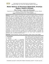
International Journal of Earth Sciences and EngineeringISSN 0974-5904, Vol. 04, No 01 - Spl issue, January 2011, pp. 17-2317Flood Inundation Mapping using IRS P6 LISS IVData - A Case Study for Vaigai River Basin withinMadurai City, TamilnaduG. KARTHIKEYAN, N. VARADHARAJAN, T. KARTHIKA and S. SURESH BABUDept of Civil Engg, Adhiyamaan College of Engineering, Hosur - 635109, Tamilnadu, IndiaEmail: gkarthick.edu@gmail.com, vrdhrajan@gmail.com, sunisurp@gmail.comAbstract: Flood Inundation Maps show the extent of flooding expected spatially over agiven area. This will indicate where roadways, streets, buildings, airports, etc., are likely tobe impacted by floodwaters. Combined with river observations inundation maps providedecision-makers, additional information needed better to mitigate the impacts of flood andbuild more resilient communities. Finally all the data has been integrated and analyzed toidentify the rehabilitation places in the study area. This Paper briefs on an attempt to mapinundated areas in a part of Vaigai river basin within Madurai city by using remote sensingdata. The focus of this paper is to find out the flood inundated area, the rehabilitation placesand to find the distance between the flood affected area and rehabilitation placesKeywords: Flood Mapping, Rehabilitation Place, Remote Sensing, Geographical informationsystem, Ops GIS 5.0Introduction:Flooding is a very common phenomenon inIndia Particularly in Tamilnadu. Thegeographic location of the country is suchthat natural river floods occur almost duringthe monsoon season Every year, onequarterto one-third of the country isinundated by overflowing rivers during themonsoon season. The floods disrupt thelives of people. In the urban areas, floodsdamage property, infrastructure and roadnetworks while floods in rural areasfrequently also cause damage to crops andloss of livestock. In Places of floods peoplelive at risk both directly through drowningand also by disrupting communications. Onthe other hand, floods have a positiveimpact on the environment. For example,floodwaters supply nutrients that enrich thesoil and recharge groundwater. Severefloods even have a positive effect on riceproduction in Tamilnadu [1] .Flood mappingduring the flooding and flood plain mappingafter the flood Recedes is essential. One ofthe important information required is thenature and extent of the damage caused byfloods in the flood prone areas. Satelliteremote sensing provides synoptic view ofthe flood-affected areas at frequent intervalsfor assessing the progression and recessionof the flood inundation in short span of timewhich can be used for planning andorganizing the relief operations effectively.Remote sensing can effectively be used formapping the flood-damaged areas. Formapping purposes, a pre-flood scene and apeak flood image would be compared todelineate the inundated area [2] .Floods notonly affects human beings but also affectvarious components of the Ecosystemconcerned. Therefore, the start date and theduration of floods play a vital role in theeconomy of the country. Remote-sensingimages can be an effective and efficient toolfor the determination of flood inundationareas and the focus of this paper is to findout the flood inundated area, therehabilitation places and to find the distancebetween the flood affected area andrehabilitation places.Study Area:Madurai, a temple town and bustling City isthe birthplace of “Tamil”, one of the oldestdravidian languages in India. PandiyanEmpire ruled Madurai during the 14 thCentury, when the world famous MeenakshiAmman Temple was built. The South Bankof Vaigai River comprises the “Old Town”where Madurai was nestled and laterexpanded around the Meenakshi Amman#<strong>02040003</strong> Copyright © 2011 CAFET-INNOVA TECHNICAL SOCIETY. All rights reserved.
20G. KARTHIKEYAN, N. VARADHARAJAN, T. KARTHIKAand S. SURESH BABUFigure 3: Vaigai River ChannelsFigure 4: Flood Affected Map in Study AreaInternational Journal of Earth Sciences and EngineeringISSN 0974-5904, Vol. 04, No 01 - Spl issue, January 2011, pp. 17-23
Flood Inundation Mapping using IRS P6 LISS IV Data- A Case Study for Vaigai River Basin within Madurai City, Tamilnadu21International Journal of Earth Sciences and EngineeringISSN 0974-5904, Vol. 04, No 01 - Spl issue, January 2011, pp. 17-23
Flood Inundation Mapping using IRS P6 LISS IV Data- A Case Study for Vaigai River Basin within Madurai City, Tamilnadu23References:[1] Anil kumar & r.p.s chhonkar- journal ofthe Indian society of remote sensing vol 17.no:1, 1989.[2] Islam m. M. And sadu k. (2001): flooddamage and modeling using satellite remotesensing data with GIS: case study ofBangladesh: in jerry Ritchie et al. (eds.),remote sensing and hydrology 2000, iahspublication, oxford, pp. 455-458.[3] City Development Plan, MaduraiCorporation, Madurai, Tamilnadu, India.[4] Second Vaigai River Plan, MaduraiCorporation, Madurai, Tamilnadu, India.[5] Islam Md. Monirul and Sado Kimiteru(2002): development priority map for floodcountermeasures by remote sensing datawith geographic information system, journalof hydrologic engineering/ September/October 2002, pp. 346-355[6] Khanna.R.K,agrawal.c.k, and pravinkumar- central water commission NewDelhi.[7] International archives of thephotogrammetry, remote sensing andspatial information science, volume xxxviii,part 8, Kyoto, Japan 2010International Journal of Earth Sciences and EngineeringISSN 0974-5904, Vol. 04, No 01 - Spl issue, January 2011, pp. 17-23