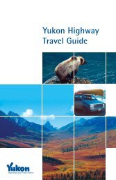
Highway Log - Highways and Public Works - Government of Yukon
Highway Log - Highways and Public Works - Government of Yukon
Highway Log - Highways and Public Works - Government of Yukon

Create successful ePaper yourself
Turn your PDF publications into a flip-book with our unique Google optimized e-Paper software.
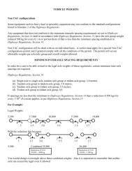
<strong>Yukon</strong> <strong>Highway</strong>s <strong>Log</strong> BookAlaska <strong>Highway</strong> (1)10/8/2008Kilometre Description Kilometre Description1136.2 50 km/h Ahead, 70 km/h Behind1244.2 George Johnston Museum1136.2 Seagull Creek1244.6 Teslin Airport Subdivision Road #1671136.7 Swift River Maintenance Camp #55001244.6 Teslin Flight Strip1137.3 YT/BC Boundary #61244.6 Teslin Maintenance Camp #58001137.4 70 km/h Ahead, 50 km/h Behind1246.0 Renewable Resources - DIAND1137.8 100 km/h Ahead, 70 km/h Behind1246.1 100 km/h Ahead, 70 km/h Behind1140.9 Partridge Creek1246.8 Rest Area1150.1 Screw Creek1247.1 Teslin Correctional Centre1152.1 Swan Lake1248.2 Teslin Tlingit Heritage Centre1158.8 Swan Lake Outfitters1248.7 Fox Creek1164.9 <strong>Log</strong>jam Creek1249.6 Fox Point Subdivision1167.9 <strong>Log</strong> Jam Creek Road1253.6 Teslin Cottage Lots - Teslin Lake Subdivision Road #1501177.3 Smart River1256.5 Mukluk Annie's Motel1186.7 Northwestel Tower - Smart1258.0 Rest Area1191.0 Hazel Creek (Upper)1258.0 Teslin Lake Campground1192.9 Hazel Creek (Lower)1258.1 Ten Mile Creek1194.0 Rest Area1264.1 Lone Tree Creek1194.0 Teslin Section Ahead, Swift River Section Behind1273.1 Deadman Creek1199.1 Andrew Creek1277.9 Timber Point1202.2 Morley Lake1283.6 Historic Mile 830 - Brook's Brook1202.6 BC/YT Boundary #71284.6 Brooks Brook1204.0 Morley River Recreation Site1284.8 Brooks Brook Road #1541204.3 Morley River1292.2 Pullout (LHS)1205.4 Historic Mile 7771294.9 70 km/h Ahead, 100 km/h Behind1205.4 Morley River Lodge1295.0 Junction Canol Rd, Hwy #6 (Km 0)1218.2 Strawberry Creek1295.5 Teslin River (South Abutment)1223.2 Hays Creek1296.0 Teslin River (North Abutment)1228.0 Historic Mile 7941296.2 Johnsons Crossing1232.2 Dawson Peaks Lodge1296.5 Johnsons Crossing West Road #1831232.3 Hett/Hase Drive #1621297.4 100 km/h Ahead, 70 km/h Behind1237.7 Forestry Demonstration Road1298.3 Pullout (LHS & RHS)1237.7 Historic Mile 8001300.4 Inn on the River Resort1240.9 Teslin Garbage Dump1303.2 Northwestel Tower - Squanga Creek1242.0 Rest Area1305.3 Squanga Lake (Airstrip-F/S #6)1242.4 50 km/h Ahead, 100 km/h Behind1313.5 Salmo Lake (South Access)1242.7 Nisutlin Bay (South Abutment)1314.3 Salmo Lake (North Access)1243.3 Nisutlin Bay (North Abutment)1314.7 Seaforth Creek1243.5 Historic Mile 8041315.9 Squanga Lake1243.9 70 km/h Ahead, 50 km/h Behind1320.7 Northwestel Tower - SquangaReportHwy<strong>Log</strong>Alaska #1 Km 1136.2 - 1320.7