Highway Log - Highways and Public Works - Government of Yukon
Highway Log - Highways and Public Works - Government of Yukon
Highway Log - Highways and Public Works - Government of Yukon

You also want an ePaper? Increase the reach of your titles
YUMPU automatically turns print PDFs into web optimized ePapers that Google loves.
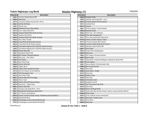
<strong>Yukon</strong> <strong>Highway</strong>s <strong>Log</strong> BookAlaska <strong>Highway</strong> (1)10/8/2008Kilometre Description Kilometre Description1436.3 Cousins Airstrip Road #1891534.8 Cracker Creek1436.4 Rest Area1546.0 Aishihik Lake Road #301 - Km 01437.0 Junction Klondike Hwy #2 (Km 191.8)1547.2 70 km/h ahead, 90 km/h behind1438.1 Old Ski Hill Road1547.5 Aishihik River1438.7 Parent Lane1547.5 Canyon1440.8 Whitehorse City Limits (North)1548.1 90 km/h ahead, 70 km/h behind1441.5 Echo Valley Road #1911562.5 Marshall Creek1441.8 Jackson Road #193 (South Access)1566.2 Rest Area - Mt. Hubbbard1442.0 Gardner Road #1611572.2 Pine Lake Campground1442.5 Jackson Road #193 (North Access)1573.1 Pine Lake Subdivision Road #1441442.8 Ibex Valley Firehall1575.0 Haines Junction Airport (1.6km)1442.9 Creek Road #190 (South Access)1577.9 Pavement ahead, BST behind1443.5 Creek Road #190 (North Access)1578.5 Junction Haines Road #3 (Km 246.1)1443.8 Old Alaska <strong>Highway</strong> #107 929-934 (South Access)1578.5 Marshall Creek Road #1381448.2 Old Alaska <strong>Highway</strong> #107 929-934 (North Access)1583.1 Pine Creek1452.5 Historic Mile 9361583.2 Kluane Park Headquarters1452.7 Woodl<strong>and</strong> Road #1801584.0 Rest Area1453.5 BST Ahead, Pavement Behind1584.2 BST ahead, Pavement behind1454.0 Rest Area - Old Takhini1589.1 Bear Creek1454.1 Old Takhini1589.1 Mackintosh Trading Post/Nygren Subdivision Road #1431468.3 Ibex River Road1594.7 Pump Station1468.8 Historic Mile 9461596.7 Spruce Beetle Trail Recreation Site1468.9 Takhini River1598.6 Bear Creek Summit1470.2 Takhini River Subdivsion Road1599.0 Rest Area1473.9 90 km/h Ahead, 50 km/h Behind1608.5 Jarvis River - Pull<strong>of</strong>f1476.7 Old Champagne Trail1610.0 Rest Area1481.0 Annie Ned Creek1614.2 Sulphur Lake1484.1 Historic Mile 956 (First Sign)1628.0 Rest Area1484.8 Stony Creek1630.4 Christmas Creek1485.0 Historic Mile 956 (Second Sign)1633.0 Bootillier Summit1487.0 Rest Area - Takhini Burn1633.6 CNT Microwave Site #1381489.1 Historic Mile 9601635.5 Rest Area1489.1 Kusawa Lake Road #314 - Km 01635.8 Silver City Road #1461495.7 Mendenhall Subdivision Road #1401636.6 Destruction Bay Section Ahead, Haines Junction Section Behind1502.1 911 Service Area Behind1636.6 Silver Creek1503.6 Haines Junction Section Ahead, Whitehorse Section Behind1638.5 Arctic Institute Access Intersection1503.6 Mendenhall River1642.1 Rest Area - Kluane Lake1504.5 Champagne Access Road #199 (South)1647.4 Slims River1518.4 Champagne Access Road #199 (North)1648.9 Rest AreaReportHwy<strong>Log</strong>Alaska #1 Km 1436.3 - 1648.9