Guiding principles for reserve management - NCC Environmental ...
Guiding principles for reserve management - NCC Environmental ...
Guiding principles for reserve management - NCC Environmental ...
- No tags were found...

Create successful ePaper yourself
Turn your PDF publications into a flip-book with our unique Google optimized e-Paper software.
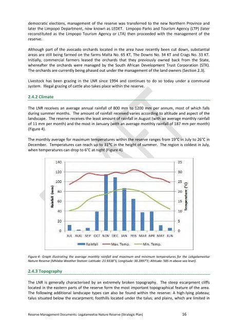
democratic elections, <strong>management</strong> of the <strong>reserve</strong> was transferred to the new Northern Province andlater the Limpopo Department, now known as LEDET. Limpopo Parks and Tourism Agency (LTP) (laterreconstituted as the Limpopo Tourism Agency or LTA) then proceeded with the <strong>management</strong> of the<strong>reserve</strong>.Although part of the avocado orchards located in the area have recently been cut down, substantialareas are still being farmed on the farms Malta No. 65 KT, The Downs No. 34 KT and Crags No. 33 KT.Initially, commercial farmers leased the orchards that they previously owned back from the State,whereafter the orchards were managed by the South African Development Trust Corporation (STK).The orchards are currently being phased out under the <strong>management</strong> of the land owners (Section 2.3).Livestock has been grazing in the LNR since 1994 and continues to do so today under a communalsystem. Illegal grazing of cattle also takes place within the <strong>reserve</strong>.2.4.2 ClimateThe LNR receives an average annual rainfall of 800 mm to 1200 mm per annum, most of which fallsduring summer months. The amount of rainfall received varies according to altitude and aspect of thelandscape. The <strong>reserve</strong> receives the least amount of rainfall in August (with an average monthly rainfallof 11 mm per month) and the most in January (with an average monthly rainfall of 187 mm per month)(Figure 4).The monthly average <strong>for</strong> maximum temperatures within the <strong>reserve</strong> ranges from 19°C in July to 26°C inDecember. Temperatures can reach up to 31⁰C in the height of summer. The region is coldest in July,when temperatures can drop to 6°C at night (Figure 4).Figure 4: Graph illustrating the average monthly rainfall and maximum and minimum temperatures <strong>for</strong> the LekgalameetseNature Reserve (Mhlaba Weather Station: Latitude: 23.9338°S; Longitude: 30.2897°E; Altitude: 585 m above sea level).2.4.3 TopographyThe LNR is generally characterised by an extremely broken topography. The steep escarpment cliffslocated in the eastern parts of the <strong>reserve</strong> <strong>for</strong>m the most important topographical feature of the area.The following additional landscape types can also be found within the <strong>reserve</strong>: A high-lying plateau;talus situated below the escarpment; foothills located under the talus; and plains, which are limited inReserve Management Documents: Legalameetse Nature Reserve (Strategic Plan) 16