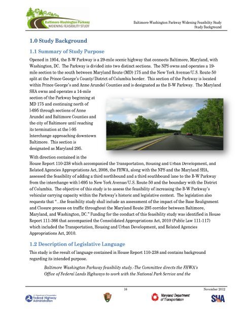
<strong>Baltimore</strong>-<strong>Washington</strong> <strong>Parkway</strong> <strong>Widening</strong> <strong>Feasibility</strong> <strong>Study</strong><strong>Study</strong> Background1.0<strong>Study</strong>Background1.1Summaryof<strong>Study</strong>PurposeOpened in 1954, the B-W <strong>Parkway</strong> is a 29-mile scenic highway that connects <strong>Baltimore</strong>, Maryland, with<strong>Washington</strong>, DC. The <strong>Parkway</strong> is divided into two distinct sections. The NPS owns and operates a 19-mile section to the south between Maryland Route (MD) 175 and the New York Avenue/U.S. Route 50split at the Prince George’s County/District of Columbia border. This section of the <strong>Parkway</strong> is locatedwithin Prince George’s and Anne Arundel Counties and is designated as the B-W <strong>Parkway</strong>. The MarylandSHA owns and operates a 14-milesection of the <strong>Parkway</strong> beginning atMD 175 and continuing north ofI-695 through sections of AnneArundel and <strong>Baltimore</strong> Counties andthe city of <strong>Baltimore</strong> until reachingits termination at the I-95Interchange approaching downtown<strong>Baltimore</strong>. This section isdesignated as Maryland 295.With direction contained in theHouse Report 110-238 which accompanied the Transportation, Housing and Urban Development, andRelated Agencies Appropriations Act, 2008, the FHWA, along with the NPS and the Maryland SHA,assessed the feasibility of adding a third northbound and a third southbound lane to the B-W <strong>Parkway</strong>from the interchange with I-695 to New York Avenue/U.S. Route 50 and the boundary with the Districtof Columbia. The objective of this study is to assess the feasibility of increasing the B-W <strong>Parkway</strong>’svehicular carrying capacity within the <strong>Parkway</strong>’s historic and legislative context. The legislation alsorequests that “…the feasibility study shall include an assessment of the impact of the Base Realignmentand Closure process on traffic throughout the Maryland Route 295 corridor between <strong>Baltimore</strong>,Maryland, and <strong>Washington</strong>, DC.” Funding for the conduct of this feasibility study was identified in HouseReport 111-366 that accompanied the Consolidated Appropriations Act, 2010 (Public Law 111-117)which included the Transportation, Housing and Urban Development, and Related AgenciesAppropriations Act, 2010.1.2DescriptionofLegislativeLanguageThis study is the result of language contained in House Report 110-238 and contains backgroundregarding its intended purpose.<strong>Baltimore</strong> <strong>Washington</strong> <strong>Parkway</strong> feasibility study.-The Committee directs the FHWA’sOffice of Federal Lands Highways to work with the National Park Service and the16 November 2012
<strong>Baltimore</strong>-<strong>Washington</strong> <strong>Parkway</strong> <strong>Widening</strong> <strong>Feasibility</strong> <strong>Study</strong><strong>Study</strong> BackgroundMaryland State Highway Administration to determine the feasibility of adding a thirdnorthbound and a third southbound lane for Maryland Route 295/<strong>Baltimore</strong> <strong>Washington</strong><strong>Parkway</strong> from the intersection with Interstate 695 to New York Avenue in the District ofColumbia. The FHWA shall prepare a report which must be submitted to the House andSenate Committees on Appropriations, not later than one year after the date ofenactment of this Act, on the feasibility of such a widening. The feasibility study shallinclude an assessment of the impact of the Base Realignment and Closure process ontraffic throughout the Maryland Route 295 corridor between <strong>Baltimore</strong>, MD and<strong>Washington</strong>, DC.1.3LegislativePurposesandSignificanceofthe<strong>Parkway</strong>The B-W <strong>Parkway</strong> is part of a system of four parkways that welcomes visitors and integrates a contextsensitivedesign to convey to citizens the importance of <strong>Washington</strong>, DC. There is the George<strong>Washington</strong> Memorial <strong>Parkway</strong> (GWMP) in Virginia running along the Potomac River shoreline from theCapital Beltway into Alexandria to George <strong>Washington</strong>’s home at Mount Vernon. There is the GWMP’sparallel companion <strong>Parkway</strong>, the Clara Barton <strong>Parkway</strong>, which runs along the Potomac River in Marylandfrom the MacArthur Boulevard to Chain Bridge. There is also the Suitland <strong>Parkway</strong>, extending from theeastern boundary of the District of Columbia to Andrews Air Force Base. Lastly, there is the Rock Creekand Potomac <strong>Parkway</strong> in the District of Columbia itself that runs from the Lincoln Memorial to just southof the National Zoo.The concept of the B-W <strong>Parkway</strong> was first proposed as an element of a planned regional system ofparkways providing access to the core of the National Capital Region in 1935, when the NPS issued theRegulations and Procedures to Govern the Acquisition of Rights-of-way for <strong>Parkway</strong>s on February 8,1935, by the Secretary of the Interior 1 . This was the first document to define a parkway characterizedby the type of roadway as one that limits access only to non-commercial and recreational traffic.Unfortunately, due to various reasons, including economic and political, the plans for the B-W <strong>Parkway</strong>stalled until the early 1940s. Over the previous decades, travel on U.S. Route 1 between <strong>Baltimore</strong>,Maryland, and <strong>Washington</strong>, DC, grew dramatically resulting in a very crowded, unsafe, and undesirabletravel experience. Pressures to relieve the traffic conditions on U.S. Route 1 pushed the Maryland StateRoad Commission to release an initial plan in 1941 for a toll road between <strong>Baltimore</strong>, and <strong>Washington</strong>,DC, which conflicted with the proposed parkway plans 2 . However, the plans for a State toll road lostsupport with time, mainly due to Federal restrictions on tolling roads that go through federally ownedlands, but the renewed interest in the B-W <strong>Parkway</strong> stressed the importance of planning a facility with avehicular as well as aesthetic and recreational value.1 United States Department of the Interior, National Park Service, National Register of Historic Places Multiple PropertyDocumentation Form, Section E - Statement of Historic Context, p22 Historic American Engineering Record, <strong>Baltimore</strong>-<strong>Washington</strong> <strong>Parkway</strong>, HAER No. MD-129, p 5017 November 2012