EMIS - UN-Habitat
EMIS - UN-Habitat
EMIS - UN-Habitat

You also want an ePaper? Increase the reach of your titles
YUMPU automatically turns print PDFs into web optimized ePapers that Google loves.
Building an Environmental Management Information System<br />
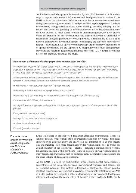
Some short definitions of a Geographic Information System (GIS)<br />
An Information System (IS) stores collected data. This data can be up-dated and manipulated and finally be<br />
displayed. In general, an IS stores data about one thematic area. A Bank Information System, for example,<br />
stores data about the bank’s customers, accounts and transactions.<br />
A Geographical Information Systems (GIS) works with spatial data. It is therefore a specific information<br />
system. A GIS has four components: Hardware, Software, Spatial data and Personnel.<br />
Hardware (i.e. Computer, GPS, Scanner, Digitizer, Printer)<br />
Software (i.e. ESRI’s ArcView, Integraph’s GeoMedia, MapInfo)<br />
Spatial data (i.e. satellite images, routes, rivers, land use data, position of landfill sites)<br />
Personnel (i.e. GIS Officer, GIS Assistant)<br />
As any Information System, a Geographical Information System consists of four phases, the EMAP<br />
phases:<br />
Entry (record, prepare, capture)<br />
Manage (store, maintain, update, integrate)<br />
Analyze (manipulate, model)<br />
Present (visualize, display)<br />
For more background<br />
information<br />
about GIS please<br />
use Reference<br />
Material A –<br />
Further Readings<br />
An Environmental Management Information System (<strong>EMIS</strong>) consists of formalised<br />
steps to capture environmental information, and fixed procedures to retrieve it. An<br />
<strong>EMIS</strong> includes the collection of information about the various environmental issues<br />
facing a particular city, supports the Issue-Specific Working Group process, continues<br />
by supporting strategy formulation and action planning, including mapping, and last<br />
but not least covers the gathering of information necessary for institutionalisation of<br />
the EPM process. To reach sound solutions in urban management, the EPM process<br />
offers an approach for inter-departmental and inter-institutional co-ordination of<br />
information through a participatory working method. Therefore, the <strong>EMIS</strong> is by its<br />
nature a participatory information system for managing the collective know-how of<br />
relevant stakeholders. Issue-specific Working Groups are the main providers and users<br />
of spatial information, and are supported by mapping professionals, cartographers,<br />
surveyors and experts in geographical information systems (GIS). <strong>EMIS</strong> information<br />
is stored in archives, databases and maps.<br />
<strong>EMIS</strong> is designed to link dispersed data about urban and environmental issues to a<br />
series of different types of maps about a particular area or even city-wide. This linkage<br />
allows users to combine, query and analyse all this information in an area-specific<br />
way and therefore to get more precise answers for routine questions. The proper setup<br />
and operation of the system will – ideally – generate a comprehensive response<br />
for a routine question within few hours. Using an <strong>EMIS</strong> to answer routine questions,<br />
many traditional drawbacks, such as dispersed data, incompatible data formats and<br />
the sheer volume of data can be overcome.<br />
As the <strong>EMIS</strong> is a tool for participatory urban environmental management, it<br />
concentrates on the interaction between environmental resources and hazards, and<br />
development activities. The system is designed to illustrate the various possible<br />
results of environment-development interactions. For example, establishing an <strong>EMIS</strong><br />
in a SCP partner city supports a better understanding of environment-development<br />
interaction throughout the various steps of the SCP process cycle. An <strong>EMIS</strong> can be<br />
12