November 2004 (PDF 11.6 MB) - Barrick Gold Corporation
November 2004 (PDF 11.6 MB) - Barrick Gold Corporation
November 2004 (PDF 11.6 MB) - Barrick Gold Corporation
- No tags were found...

You also want an ePaper? Increase the reach of your titles
YUMPU automatically turns print PDFs into web optimized ePapers that Google loves.
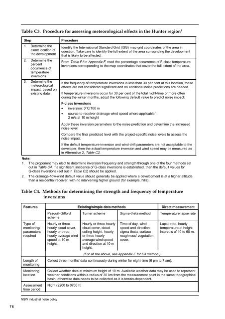
Table C3. Procedure for assessing meteorological effects in the Hunter region 1Step1. Determine theexact location ofthe development2. Determine thepercentoccurrence oftemperatureinversions3. Determine themeteorologicalimpact, based onexisting dataProcedureIdentify the International Standard Grid (ISG) map grid coordinates of the area inquestion. Take care to identify the full extent of the area surrounding the developmentthat is likely to be affected.From Table F1 in Appendix F, read the percentage occurrence of F-class temperatureinversions corresponding to the map coordinates that cover the full extent of the area.If the frequency of temperature inversions is less than 30 per cent at this location, theseeffects are not considered significant and no additional noise predictions are needed.If temperature inversions occur for 30 per cent of the total night-time or more oftenduring the winter months, adopt the following default value to predict noise impact:F-class inversions• inversion: 3°C/100 m• source-to-receiver drainage-wind speed where applicable 2 :2 m/s at 10 m heightApply these inversion parameters to the noise prediction and determine the increasednoise level.Compare the final predicted level with the project-specific noise levels to assess thenoise impact.If the default temperature-inversion and wind-drift parameters are not acceptable to thedeveloper, then the actual temperature inversion and wind speed may be measured asin Alternative 2, Table C2.Note:1. The proponent may elect to determine inversion frequency and strength through one of the four methods setout in Table C4. If a significant incidence of G-class inversions is established, then the default values forG-class inversions (set out in Table C2) should be applied.2. The drainage-flow-wind default value should generally be applied where a development is at a higher altitudethan a residential receiver, with no intervening higher ground (for example, hills).Table C4. Methods for determining the strength and frequency of temperatureinversionsFeaturesExisting/simple data methodsDirect measurementPasquill-GiffordschemeTurner scheme Sigma-theta method Temperature lapse rateType ofmonitoring/parametersrequiredHourly or threehourlycloud cover,hourly or threehourlyaverage windspeed at 10 mheight.Hourly or three-hourlycloud cover, cloudceilingheight, hourlyor three-hourlyaverage wind speedand direction at 10 mheight.Time of day, windspeed and direction,sigma-theta, surfaceroughness/ vegetationcover.Lapse rate, hourlytemperature at heightintervals of 10 to 60 m.(For all the above, see Appendix E for full method.)Length ofmonitoringMonitoringlocationAssessmenttime periodCollect three months' data continuously during winter for night-time (6 pm to 7 am).Collect weather data at minimum height of 10 m. Available weather data may be used to representweather conditions within a radius of 30 km from the measurement point in the same topographicalbasin; otherwise data needs to be collected as it is terrain-dependent.Night (2200 to 0700 h)NSW industrial noise policy76