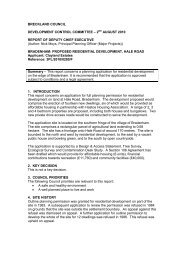
Adopted Site Specific Policies and Proposals Development Plan ...
Adopted Site Specific Policies and Proposals Development Plan ...
Adopted Site Specific Policies and Proposals Development Plan ...

Create successful ePaper yourself
Turn your PDF publications into a flip-book with our unique Google optimized e-Paper software.
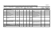
2168525106144447194354423521Water11132383113138CHALK LANE20282EASTFIELDS3953186152127415179<strong>Adopted</strong> <strong>Site</strong> <strong>Specific</strong> <strong>Policies</strong> <strong>and</strong> <strong>Proposals</strong> <strong>Development</strong> <strong>Plan</strong> DocumentNarborough AllocationOld Spruce <strong>Plan</strong>tationThis map is reproduced from Ordnance Survey material with the permission of Ordnance Survey on behalf of the Controller of Her Majesty's Stationery Office © Crown copyright.Unauthorised reproduction infringes Crown copyright <strong>and</strong> may lead to prosecution or civil proceedings. Breckl<strong>and</strong> District Council licence no.100019535. Published 2005.DrainDrainTk DCo Const, CP & ED BdyChestnutWaterWaterDrainWaterFish FarmWater10.5mAllotGdnsWaterDrainSpruce<strong>Plan</strong>tation10.4mThe PotteryPondLBThe ShipInnSlSlBelgraveBankLodgeTudno LodgeGarageWatersideWaterDrainDrainWaterWaterWaterWaterDrainFBFBDrainUndFBThe MaltingsThe GrangeFBWaterFish House<strong>Plan</strong>tationRiver NarFBSurgeryDairyFBSluiceBlanche's<strong>Plan</strong>tationMAIN10.4mMillFBWaterROADFBBoat HouseLittle NarsideNarsidePathPath (um)PalisaPark CottageNarborough HallWillowRIVER CLOSEThe LodgeCamphill <strong>Plan</strong>tationWaysideFortPondChapel CottageTrackMeal HouseStack Yard4Church Farm BarnsClestrain1Church Farm12.7mAll Saint's ChurchNarford Lane <strong>Plan</strong>tationPath (um)PondNarborough14.0mDismantled RailwayThe VicaragePavilion28Cricket FieldFour Seasons17.1m2235El Sub871681367710096OLD92PARK5743PagetHamlynMAIN ROADForgeEdgeTurangiShelterIcehouse16.4mSchoolHouse11El Sub Sta1017671676650Wagtails4BLACKSMITHS WAYElThe Sorrels14.0m15.4mMacs Shelter2Narborough105Church of Engl<strong>and</strong>Voluntary ControlledPrimary SchoolBO OTH CLOSE1413AllotmentGardens28DENNY'S WALK118TCB315.3m110913PO11Br<strong>and</strong>ymelSwaffham Lane <strong>Plan</strong>tationBrock House30Gate363031Tel Ex45SWAFFHAM RO ADThe GrangeClaremarlyn443544403932MEADOW CLOSE291CHALK LANE55107MITCHELLS WAY8281Pp HoChalk HouseSub136470861419ElSta9297101898587610111314WESTFIELDS7576816060493515.0m31El Sub Sta7868Portl<strong>and</strong>7139109117S<strong>and</strong>toft70Drain43104103Capel CottagePond232430Playing Field1412a127Butler's BarnNAR.1CentrePondButler'sCarrMap 2.4 Summary of Narborough Allocations39