Soils of the European Union - European Soil Portal - Europa
Soils of the European Union - European Soil Portal - Europa
Soils of the European Union - European Soil Portal - Europa

You also want an ePaper? Increase the reach of your titles
YUMPU automatically turns print PDFs into web optimized ePapers that Google loves.
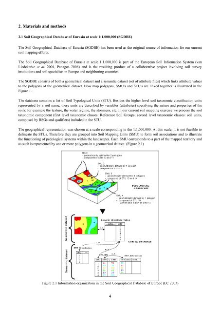
2. Materials and methods2.1 <strong>Soil</strong> Geographical Database <strong>of</strong> Eurasia at scale 1:1,000,000 (SGDBE)The <strong>Soil</strong> Geographical Database <strong>of</strong> Eurasia (SGDBE) has been used as <strong>the</strong> original source <strong>of</strong> information for our currentsoil mapping efforts.The <strong>Soil</strong> Geographical Database <strong>of</strong> Eurasia at scale 1:1,000,000 is part <strong>of</strong> <strong>the</strong> <strong>European</strong> <strong>Soil</strong> Information System (vanLiedekerke et al. 2004, Panagos 2006) and is <strong>the</strong> resulting product <strong>of</strong> a collaborative project involving soil surveyinstitutions and soil specialists in Europe and neighboring countries.The SGDBE consists <strong>of</strong> both a geometrical dataset and a semantic dataset (set <strong>of</strong> attribute files) which links attribute valuesto <strong>the</strong> polygons <strong>of</strong> <strong>the</strong> geometrical dataset. How map polygons, SMU's and STU's are linked toge<strong>the</strong>r is illustrated in <strong>the</strong>Figure 1.The database contains a list <strong>of</strong> <strong>Soil</strong> Typological Units (STU). Besides <strong>the</strong> higher level soil taxonomic classification unitsrepresented by a soil name, <strong>the</strong>se units are described by variables (attributes) specifying <strong>the</strong> nature and properties <strong>of</strong> <strong>the</strong>soils: for example <strong>the</strong> texture, <strong>the</strong> water regime, <strong>the</strong> stoniness, etc. In our current soil mapping exercise we process <strong>the</strong> soiltaxonomic component (first level taxonomic classes: Reference <strong>Soil</strong> Groups; second level taxonomic classes: soil units,composed by RSGs and qualifiers) included in <strong>the</strong> STU.The geographical representation was chosen at a scale corresponding to <strong>the</strong> 1:1,000,000. At this scale, it is not feasible todelineate <strong>the</strong> STUs. Therefore <strong>the</strong>y are grouped into <strong>Soil</strong> Mapping Units (SMU) to form soil associations and to illustrate<strong>the</strong> functioning <strong>of</strong> pedological systems within <strong>the</strong> landscapes. Each SMU corresponds to a part <strong>of</strong> <strong>the</strong> mapped territory andas such is represented by one or more polygons in a geometrical dataset. (Figure 2.1)Figure 2.1 Information organization in <strong>the</strong> <strong>Soil</strong> Geographical Database <strong>of</strong> Europe (EC 2003)4