Soils of the European Union - European Soil Portal - Europa
Soils of the European Union - European Soil Portal - Europa
Soils of the European Union - European Soil Portal - Europa

You also want an ePaper? Increase the reach of your titles
YUMPU automatically turns print PDFs into web optimized ePapers that Google loves.
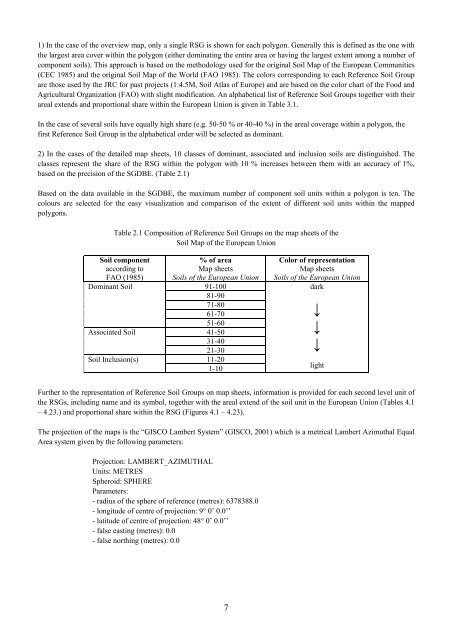
1) In <strong>the</strong> case <strong>of</strong> <strong>the</strong> overview map, only a single RSG is shown for each polygon. Generally this is defined as <strong>the</strong> one with<strong>the</strong> largest area cover within <strong>the</strong> polygon (ei<strong>the</strong>r dominating <strong>the</strong> entire area or having <strong>the</strong> largest extent among a number <strong>of</strong>component soils). This approach is based on <strong>the</strong> methodology used for <strong>the</strong> original <strong>Soil</strong> Map <strong>of</strong> <strong>the</strong> <strong>European</strong> Communities(CEC 1985) and <strong>the</strong> original <strong>Soil</strong> Map <strong>of</strong> <strong>the</strong> World (FAO 1985). The colors corresponding to each Reference <strong>Soil</strong> Groupare those used by <strong>the</strong> JRC for past projects (1:4.5M, <strong>Soil</strong> Atlas <strong>of</strong> Europe) and are based on <strong>the</strong> color chart <strong>of</strong> <strong>the</strong> Food andAgricultural Organization (FAO) with slight modification. An alphabetical list <strong>of</strong> Reference <strong>Soil</strong> Groups toge<strong>the</strong>r with <strong>the</strong>irareal extends and proportional share within <strong>the</strong> <strong>European</strong> <strong>Union</strong> is given in Table 3.1.In <strong>the</strong> case <strong>of</strong> several soils have equally high share (e.g. 50-50 % or 40-40 %) in <strong>the</strong> areal coverage within a polygon, <strong>the</strong>first Reference <strong>Soil</strong> Group in <strong>the</strong> alphabetical order will be selected as dominant.2) In <strong>the</strong> cases <strong>of</strong> <strong>the</strong> detailed map sheets, 10 classes <strong>of</strong> dominant, associated and inclusion soils are distinguished. Theclasses represent <strong>the</strong> share <strong>of</strong> <strong>the</strong> RSG within <strong>the</strong> polygon with 10 % increases between <strong>the</strong>m with an accuracy <strong>of</strong> 1%,based on <strong>the</strong> precision <strong>of</strong> <strong>the</strong> SGDBE. (Table 2.1)Based on <strong>the</strong> data available in <strong>the</strong> SGDBE, <strong>the</strong> maximum number <strong>of</strong> component soil units within a polygon is ten. Thecolours are selected for <strong>the</strong> easy visualization and comparison <strong>of</strong> <strong>the</strong> extent <strong>of</strong> different soil units within <strong>the</strong> mappedpolygons.Table 2.1 Composition <strong>of</strong> Reference <strong>Soil</strong> Groups on <strong>the</strong> map sheets <strong>of</strong> <strong>the</strong><strong>Soil</strong> Map <strong>of</strong> <strong>the</strong> <strong>European</strong> <strong>Union</strong><strong>Soil</strong> componentaccording toFAO (1985)Dominant <strong>Soil</strong>Associated <strong>Soil</strong><strong>Soil</strong> Inclusion(s)% <strong>of</strong> areaMap sheets<strong><strong>Soil</strong>s</strong> <strong>of</strong> <strong>the</strong> <strong>European</strong> <strong>Union</strong>91-10081-9071-8061-7051-6041-5031-4021-3011-201-10Color <strong>of</strong> representationMap sheets<strong><strong>Soil</strong>s</strong> <strong>of</strong> <strong>the</strong> <strong>European</strong> <strong>Union</strong>dark↓↓↓lightFur<strong>the</strong>r to <strong>the</strong> representation <strong>of</strong> Reference <strong>Soil</strong> Groups on map sheets, information is provided for each second level unit <strong>of</strong><strong>the</strong> RSGs, including name and its symbol, toge<strong>the</strong>r with <strong>the</strong> areal extend <strong>of</strong> <strong>the</strong> soil unit in <strong>the</strong> <strong>European</strong> <strong>Union</strong> (Tables 4.1– 4.23.) and proportional share within <strong>the</strong> RSG (Figures 4.1 – 4.23).The projection <strong>of</strong> <strong>the</strong> maps is <strong>the</strong> “GISCO Lambert System” (GISCO, 2001) which is a metrical Lambert Azimuthal EqualArea system given by <strong>the</strong> following parameters:Projection: LAMBERT_AZIMUTHALUnits: METRESSpheroid: SPHEREParameters:- radius <strong>of</strong> <strong>the</strong> sphere <strong>of</strong> reference (metres): 6378388.0- longitude <strong>of</strong> centre <strong>of</strong> projection: 9° 0’ 0.0’’- latitude <strong>of</strong> centre <strong>of</strong> projection: 48° 0’ 0.0’’- false easting (metres): 0.0- false northing (metres): 0.07