Soils of the European Union - European Soil Portal - Europa
Soils of the European Union - European Soil Portal - Europa
Soils of the European Union - European Soil Portal - Europa

You also want an ePaper? Increase the reach of your titles
YUMPU automatically turns print PDFs into web optimized ePapers that Google loves.
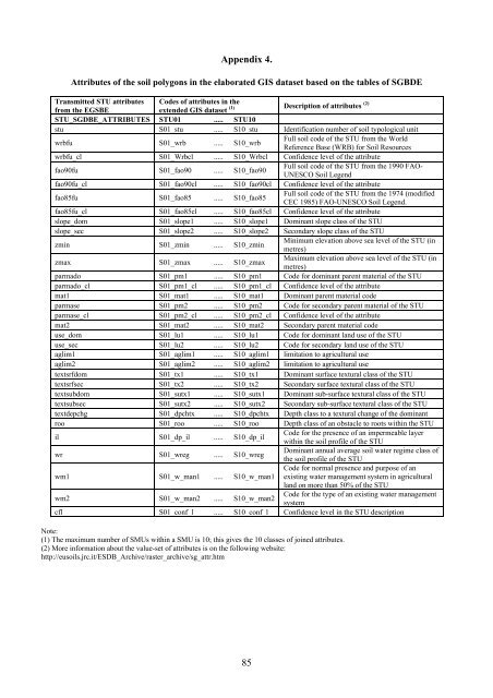
Appendix 4.Attributes <strong>of</strong> <strong>the</strong> soil polygons in <strong>the</strong> elaborated GIS dataset based on <strong>the</strong> tables <strong>of</strong> SGBDETransmitted STU attributes Codes <strong>of</strong> attributes in <strong>the</strong>from <strong>the</strong> EGSBEextended GIS dataset (1) Description <strong>of</strong> attributes (2)STU_SGDBE_ATTRIBUTES STU01 ..... STU10stu S01_stu ..... S10_stu Identification number <strong>of</strong> soil typological unitwrbfu S01_wrb ..... S10_wrbFull soil code <strong>of</strong> <strong>the</strong> STU from <strong>the</strong> WorldReference Base (WRB) for <strong>Soil</strong> Resourceswrbfu_cl S01_Wrbcl ..... S10_Wrbcl Confidence level <strong>of</strong> <strong>the</strong> attributefao90fu S01_fao90 ..... S10_fao90Full soil code <strong>of</strong> <strong>the</strong> STU from <strong>the</strong> 1990 FAO-UNESCO <strong>Soil</strong> Legendfao90fu_cl S01_fao90cl ..... S10_fao90cl Confidence level <strong>of</strong> <strong>the</strong> attributefao85fu S01_fao85 ..... S10_fao85Full soil code <strong>of</strong> <strong>the</strong> STU from <strong>the</strong> 1974 (modifiedCEC 1985) FAO-UNESCO <strong>Soil</strong> Legend.fao85fu_cl S01_fao85cl ..... S10_fao85cl Confidence level <strong>of</strong> <strong>the</strong> attributeslope_dom S01_slope1 ..... S10_slope1 Dominant slope class <strong>of</strong> <strong>the</strong> STUslope_sec S01_slope2 ..... S10_slope2 Secondary slope class <strong>of</strong> <strong>the</strong> STUzmin S01_zmin ..... S10_zminMinimum elevation above sea level <strong>of</strong> <strong>the</strong> STU (inmetres)zmax S01_zmax ..... S10_zmaxMaximum elevation above sea level <strong>of</strong> <strong>the</strong> STU (inmetres)parmado S01_pm1 ..... S10_pm1 Code for dominant parent material <strong>of</strong> <strong>the</strong> STUparmado_cl S01_pm1_cl ..... S10_pm1_cl Confidence level <strong>of</strong> <strong>the</strong> attributemat1 S01_mat1 ..... S10_mat1 Dominant parent material codeparmase S01_pm2 ..... S10_pm2 Code for secondary parent material <strong>of</strong> <strong>the</strong> STUparmase_cl S01_pm2_cl ..... S10_pm2_cl Confidence level <strong>of</strong> <strong>the</strong> attributemat2 S01_mat2 ..... S10_mat2 Secondary parent material codeuse_dom S01_lu1 ..... S10_lu1 Code for dominant land use <strong>of</strong> <strong>the</strong> STUuse_sec S01_lu2 ..... S10_lu2 Code for secondary land use <strong>of</strong> <strong>the</strong> STUaglim1 S01_aglim1 ..... S10_aglim1 limitation to agricultural useaglim2 S01_aglim2 ..... S10_aglim2 limitation to agricultural usetextsrfdom S01_tx1 ..... S10_tx1 Dominant surface textural class <strong>of</strong> <strong>the</strong> STUtextsrfsec S01_tx2 ..... S10_tx2 Secondary surface textural class <strong>of</strong> <strong>the</strong> STUtextsubdom S01_sutx1 ..... S10_sutx1 Dominant sub-surface textural class <strong>of</strong> <strong>the</strong> STUtextsubsec S01_sutx2 ..... S10_sutx2 Secondary sub-surface textural class <strong>of</strong> <strong>the</strong> STUtextdepchg S01_dpchtx ..... S10_dpchtx Depth class to a textural change <strong>of</strong> <strong>the</strong> dominantroo S01_roo ..... S10_roo Depth class <strong>of</strong> an obstacle to roots within <strong>the</strong> STUil S01_dp_il ..... S10_dp_ilCode for <strong>the</strong> presence <strong>of</strong> an impermeable layerwithin <strong>the</strong> soil pr<strong>of</strong>ile <strong>of</strong> <strong>the</strong> STUwr S01_wreg ..... S10_wregDominant annual average soil water regime class <strong>of</strong><strong>the</strong> soil pr<strong>of</strong>ile <strong>of</strong> <strong>the</strong> STUwm1 S01_w_man1 ..... S10_w_man1Code for normal presence and purpose <strong>of</strong> anexisting water management system in agriculturalland on more than 50% <strong>of</strong> <strong>the</strong> STUwm2 S01_w_man2 ..... S10_w_man2Code for <strong>the</strong> type <strong>of</strong> an existing water managementsystemcfl S01_conf_l ..... S10_conf_l Confidence level in <strong>the</strong> STU descriptionNote:(1) The maximum number <strong>of</strong> SMUs within a SMU is 10; this gives <strong>the</strong> 10 classes <strong>of</strong> joined attributes.(2) More information about <strong>the</strong> value-set <strong>of</strong> attributes is on <strong>the</strong> following website:http://eusoils.jrc.it/ESDB_Archive/raster_archive/sg_attr.htm85