Wolf Bay Plan Final - Mobile Bay National Estuary Program
Wolf Bay Plan Final - Mobile Bay National Estuary Program
Wolf Bay Plan Final - Mobile Bay National Estuary Program
- No tags were found...

Create successful ePaper yourself
Turn your PDF publications into a flip-book with our unique Google optimized e-Paper software.
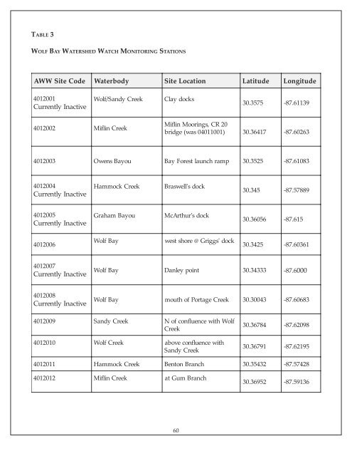
TABLE 3WOLF BAY WATERSHED WATCH MONITORING STATIONSAWW SiteCodeWaterbodySiteLocationLatitudeLongitude4012001Currently Inactive<strong>Wolf</strong>/SandyCreekClay docks30.3575-87.611394012002Miflin CreekMiflin Moorings, CR 20bridge(was 04011001) 30.36417-87.602634012003Owens<strong>Bay</strong>ou<strong>Bay</strong>Forest launch ramp30.3525-87.610834012004Currently InactiveHammockCreekBraswell's dock30.345-87.578894012005Currently InactiveGraham <strong>Bay</strong>ouMcArthur's dock30.36056-87.6154012006<strong>Wolf</strong><strong>Bay</strong>west shore @ Griggs' dock30.3425-87.603614012007Currently Inactive<strong>Wolf</strong><strong>Bay</strong>Danleypoint30.34333-87.60004012008Currently Inactive<strong>Wolf</strong><strong>Bay</strong>mouth of Portage Creek30.30043-87.606834012009SandyCreek4012010<strong>Wolf</strong>CreekN of confluenceCreekabove confluenceSandy Creekwith <strong>Wolf</strong>with30.36784-87.6209830.36791-87.621954012011HammockCreekBenton Branch30.35432-87.574284012012Miflin Creekat Gum Branch30.36952-87.5913660