Wolf Bay Plan Final - Mobile Bay National Estuary Program
Wolf Bay Plan Final - Mobile Bay National Estuary Program
Wolf Bay Plan Final - Mobile Bay National Estuary Program
- No tags were found...

Create successful ePaper yourself
Turn your PDF publications into a flip-book with our unique Google optimized e-Paper software.
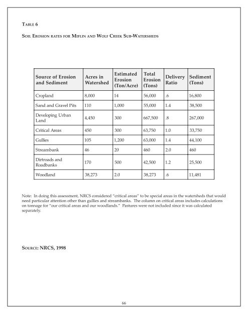
TABLE 6SOIL EROSION RATES FOR MIFLIN AND WOLF CREEK SUB-WATERSHEDSSource of Erosionand SedimentAcres inWatershedEstimatedErosion(Ton/Acre)TotalErosion(Tons)DeliveryRatioSediment(Tons)Cropland8,0001456,000. 6 16,800Sand and Gravel Pits 1101,00055,0001.4 38,500DevelopingLandUrban4,450300667,500. 8 267,000CriticalAreas45030063,7501.0 33,750Gullies1051,20063,0001.4 44,100Streambank46204602.0 460Dirtroads andRoadbanks17050042,5001.2 25,500Woodland38,2732.038,273. 6 11,481Note: In doing this assessment, NRCS considered “critical areas” to be special areas in the watersheds that wouldneed particular attention other than gullies and streambanks. The column on critical areas includes calculationson tonnage for “our critical areas and our woodlands.” Pastures were not included since it was calculatedseparately.SOURCE: NRCS, 199866