Master Plan - City of Troy
Master Plan - City of Troy
Master Plan - City of Troy

You also want an ePaper? Increase the reach of your titles
YUMPU automatically turns print PDFs into web optimized ePapers that Google loves.
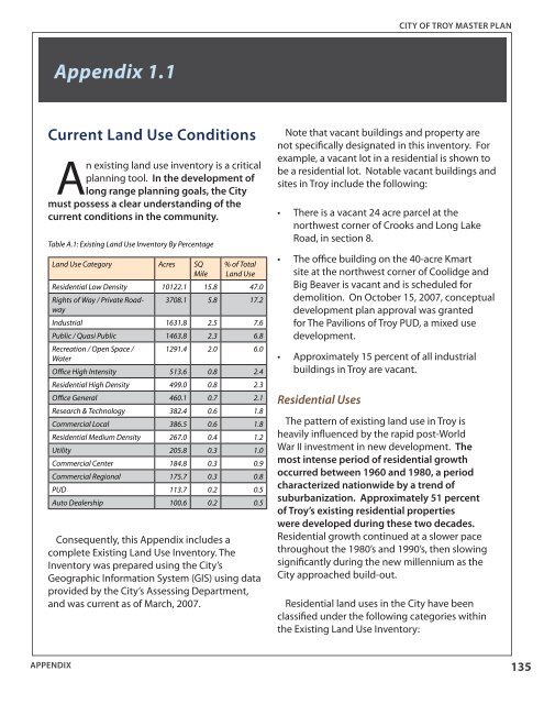
CITY OF TROY MASTER PLANAppendix 1.1Current Land Use ConditionsAn existing land use inventory is a criticalplanning tool. In the development <strong>of</strong>long range planning goals, the <strong>City</strong>must possess a clear understanding <strong>of</strong> thecurrent conditions in the community.Table A.1: Existing Land Use Inventory By PercentageLand Use Category Acres SQMile% <strong>of</strong> TotalLand UseResidential Low Density 10122.1 15.8 47.0Rights <strong>of</strong> Way / Private Roadway3708.1 5.8 17.2Industrial 1631.8 2.5 7.6Public / Quasi Public 1463.8 2.3 6.8Recreation / Open Space /1291.4 2.0 6.0WaterOffice High Intensity 513.6 0.8 2.4Residential High Density 499.0 0.8 2.3Office General 460.1 0.7 2.1Research & Technology 382.4 0.6 1.8Commercial Local 386.5 0.6 1.8Residential Medium Density 267.0 0.4 1.2Utility 205.8 0.3 1.0Commercial Center 184.8 0.3 0.9Commercial Regional 175.7 0.3 0.8PUD 113.7 0.2 0.5Auto Dealership 100.6 0.2 0.5Consequently, this Appendix includes acomplete Existing Land Use Inventory. TheInventory was prepared using the <strong>City</strong>’sGeographic Information System (GIS) using dataprovided by the <strong>City</strong>’s Assessing Department,and was current as <strong>of</strong> March, 2007.Note that vacant buildings and property arenot specifically designated in this inventory. Forexample, a vacant lot in a residential is shown tobe a residential lot. Notable vacant buildings andsites in <strong>Troy</strong> include the following:• There is a vacant 24 acre parcel at thenorthwest corner <strong>of</strong> Crooks and Long LakeRoad, in section 8.• The <strong>of</strong>fice building on the 40-acre Kmartsite at the northwest corner <strong>of</strong> Coolidge andBig Beaver is vacant and is scheduled fordemolition. On October 15, 2007, conceptualdevelopment plan approval was grantedfor The Pavilions <strong>of</strong> <strong>Troy</strong> PUD, a mixed usedevelopment.• Approximately 15 percent <strong>of</strong> all industrialbuildings in <strong>Troy</strong> are vacant.Residential UsesThe pattern <strong>of</strong> existing land use in <strong>Troy</strong> isheavily influenced by the rapid post-WorldWar II investment in new development. Themost intense period <strong>of</strong> residential growthoccurred between 1960 and 1980, a periodcharacterized nationwide by a trend <strong>of</strong>suburbanization. Approximately 51 percent<strong>of</strong> <strong>Troy</strong>’s existing residential propertieswere developed during these two decades.Residential growth continued at a slower pacethroughout the 1980’s and 1990’s, then slowingsignificantly during the new millennium as the<strong>City</strong> approached build-out.Residential land uses in the <strong>City</strong> have beenclassified under the following categories withinthe Existing Land Use Inventory:APPENDIX135