ICS Forms - West Virginia Division of Homeland Security
ICS Forms - West Virginia Division of Homeland Security
ICS Forms - West Virginia Division of Homeland Security
- No tags were found...

Create successful ePaper yourself
Turn your PDF publications into a flip-book with our unique Google optimized e-Paper software.
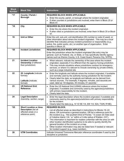
BlockNumberBlock Title*17 County / Parish /BoroughInstructionsREQUIRED BLOCK WHEN APPLICABLE.Enter the county, parish, or borough where the incident originated.If other counties or jurisdictions are involved, enter them in Block 25 orBlock 47.*18 City REQUIRED BLOCK WHEN APPLICABLE.Enter the city where the incident originated.If other cities or jurisdictions are involved, enter them in Block 25 or Block47.19 Unit or Other Enter the unit, sub-unit, unit identification (ID) number or code (if used), orother information about where the incident originated. This may be a localidentifier that indicates primary incident jurisdiction or responsibility (e.g.,police, fire, public works, etc.) or another type <strong>of</strong> organization. Enterspecifics in Block 25.*20 Incident Jurisdiction REQUIRED BLOCK WHEN APPLICABLE.Enter the jurisdiction where the incident originated (the entry may begeneral, such as Federal, city, or State, or may specifically identify agencynames such as Warren County, U.S. Coast Guard, Panama City, NYPD).21 Incident LocationOwnership (if differentthan jurisdiction)22 22. Longitude (indicateformat):Latitude (indicateformat):23 US National GridReference24 Legal Description(township, section, range)*25 Short Location or AreaDescription (list allaffected areas or areference point)When relevant, indicate the ownership <strong>of</strong> the area where the incidentoriginated, especially if it is different than the agency having jurisdiction.This may include situations where jurisdictions contract for emergencyservices, or where it is relevant to include ownership by private entities,such as a large industrial site.Enter the longitude and latitude where the incident originated, if availableand normally used by the authority having jurisdiction for the incident.Clearly label the data, as longitude and latitude can be derived fromvarious sources. For example, if degrees, minutes, and seconds areused, label as “33 degrees, 45 minutes, 01 seconds.”Enter the US National Grid (USNG) reference where the incidentoriginated, if available and commonly used by the agencies/jurisdictionswith primary responsibility for the incident.Clearly label the data.Enter the legal description where the incident originated, if available andcommonly used by the agencies/jurisdictions with primary responsibilityfor the incident.Clearly label the data (e.g., N 1/2 SE 1/4, SW 1/4, S24, T32N, R18E).REQUIRED BLOCK.List all affected areas as described in instructions for Blocks 16–24above, OR summarize a general location, OR list a reference point forthe incident (e.g., “the southern third <strong>of</strong> Florida,” “in ocean 20 miles west<strong>of</strong> Catalina Island, CA,” or “within a 5 mile radius <strong>of</strong> Walden, CO”).This information is important for readers unfamiliar with the area (or withother location identification systems) to be able to quickly identify thegeneral location <strong>of</strong> the incident on a map.Other location information may also be listed here if needed or relevantfor incident support (e.g., base meridian).26 UTM Coordinates Indicate Universal Transverse Mercator reference coordinates if used by thediscipline or jurisdiction.